TopoQuest Logo
Do you find TopoQuest useful?
Help keep TopoQuest running and adding new maps/features by donating!
Bitcoin:  19c7KJd3qBynnjoSw5npx9KScwjBe4ifkT
Litecoin:  LXs6TkuXGGXo1vDsWCkWVdjQX94eUKd6ui
Home View Maps Find Maps Find Places Resources & Links


Gilboa, New York Topographic Map

USGS Map Title: Gilboa, NY
USGS Map MRC: 42074D4
DRG (GeoTIFF) Download: o42074d4.tif


Neighboring USGS Topographic Map Quads:


  Summit, NY  
42074E5
 

  Breakabeen, NY  
42074E4
 

  Middleburgh, NY  
42074E3
 

  Stamford, NY  
42074D5
 

  Gilboa, NY  
42074D4
 

  Livingstonville, NY  
42074D3
 

  Roxbury, NY  
42074C5
 

  Prattsville, NY  
42074C4
 

  Ashland, NY  
42074C3


Map MRC Location:

N43°
W75°
N43°
W74°
H8 H7 H6 H5 H4 H3 H2 H1
G8 G7 G6 G5 G4 G3 G2 G1
F8 F7 F6 F5 F4 F3 F2 F1
E8 E7 E6 E5 E4 E3 E2 E1
D8 D7 D6 D5 D4 D3 D2 D1
C8 C7 C6 C5 C4 C3 C2 C1
B8 B7 B6 B5 B4 B3 B2 B1
A8 A7 A6 A5 A4 A3 A2 A1
N42°
W75°
N42°
W74°

Gilboa, NY USGS 1:24K Topographic Map Preview:
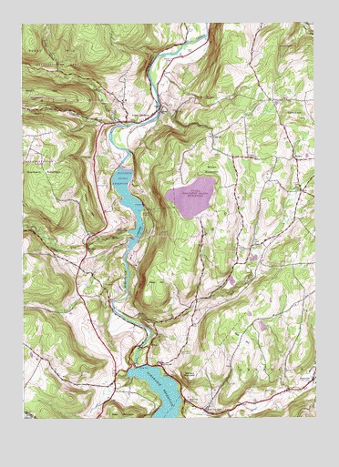
Gilboa, NY USGS Topographic Map
Click on map above to begin viewing in our Map Viewer.

This topographic map contains these locations and features:
Feature Name Type Latitude Longitude GNIS ID View Map
B/G HeliportAirportN42.4247°W74.4508°975791View Map
Bear KillStreamN42.3845°W74.3768°943276View Map
Blenheim Covered BridgeBridgeN42.4717°W74.4414°2097330View Map
Blenheim Gilboa ReservoirReservoirN42.4429°W74.4543°2554813View Map
Blenheim Hose CompanyBuildingN42.4686°W74.4554°2735228View Map
Blenheim MountainSummitN42.4551°W74.4924°944238View Map
Bornt HillSummitN42.4195°W74.4643°944462View Map
Bridge SchoolSchoolN42.4720°W74.4413°944724View Map
Brown MountainSummitN42.4551°W74.4193°944921View Map
Bull HillSummitN42.3987°W74.4038°945127View Map
Burnt HillSummitN42.4976°W74.4963°969934View Map
Central SchoolSchoolN42.3920°W74.4410°946291View Map
Clapper CemeteryCemeteryN42.4579°W74.4032°946728View Map
ConesvillePopulated PlaceN42.3873°W74.3763°947266View Map
Conesville Town HallBuildingN42.3857°W74.3776°2617600View Map
Country Road CampgroundLocaleN42.4319°W74.4266°2615197View Map
Doney HollowValleyN42.4844°W74.4834°948568View Map
Five CornersLocaleN42.4467°W74.3804°950194View Map
Flat CreekPopulated PlaceN42.4301°W74.4015°972481View Map
Flat Creek CemeteryCemeteryN42.4285°W74.4050°949533View Map
GilboaPopulated PlaceN42.3973°W74.4460°951100View Map
Gilboa DamDamN42.3917°W74.4496°951101View Map
Gilboa Rural CemeteryCemeteryN42.3956°W74.4320°963079View Map
Hager CemeteryCemeteryN42.4911°W74.4267°951987View Map
Kniskern CemeteryCemeteryN42.4883°W74.4363°954781View Map
MackeyPopulated PlaceN42.4573°W74.3835°956236View Map
Manor KillStreamN42.3804°W74.4326°956373View Map
Manorkill FallsFallsN42.3806°W74.4307°956380View Map
Mill CreekStreamN42.4692°W74.4601°957225View Map
Mine KillStreamN42.4379°W74.4493°957385View Map
Mine Kill FallsFallsN42.4290°W74.4721°957386View Map
Mine Kill State ParkParkN42.4330°W74.4631°2504749View Map
Moore CemeteryCemeteryN42.4489°W74.3820°957593View Map
Nickerson Park CampgroundLocaleN42.4157°W74.4594°2615224View Map
North BlenheimPopulated PlaceN42.4709°W74.4454°958689View Map
North Blenheim Post OfficePost OfficeN42.4686°W74.4556°2618042View Map
OwlsvillePopulated PlaceN42.4645°W74.4190°972904View Map
Patrie CemeteryCemeteryN42.3800°W74.4001°959985View Map
Platter KillStreamN42.4054°W74.4507°960697View Map
Quiery HillSummitN42.4395°W74.4707°962099View Map
Reed HillSummitN42.4167°W74.4415°962347View Map
Richtmyer Case CemeteryCemeteryN42.3833°W74.3924°962484View Map
Safford CemeteryCemeteryN42.4755°W74.3910°963213View Map
Safford HillSummitN42.4709°W74.3821°963214View Map
Shafer CemeteryCemeteryN42.4977°W74.4285°964911View Map
Shew HollowValleyN42.4337°W74.4524°965104View Map
Stevens MountainSummitN42.3881°W74.4290°966384View Map
Town of BlenheimCivilN42.4834°W74.4893°978738View Map
Town of GilboaCivilN42.4303°W74.4551°979001View Map
United Methodist ChurchChurchN42.4713°W74.4438°2617126View Map
Upper Blenheim Gilboa ReservoirReservoirN42.4397°W74.4242°2554814View Map
Welch HillSummitN42.4784°W74.4976°969022View Map
West ConesvillePopulated PlaceN42.3779°W74.4224°969183View Map
West Conesville CemeteryCemeteryN42.3791°W74.4199°2554571View Map
West KillStreamN42.4679°W74.4560°977475View Map

Note: Coordinates in the location and feature list above are referenced to NAD83 datum.


Copyright (C) 2008-2024 Ryan Niemi / Sunset Dynamics ... All Rights Reserved