TopoQuest Logo
Do you find TopoQuest useful?
Help keep TopoQuest running and adding new maps/features by donating!
Bitcoin:  19c7KJd3qBynnjoSw5npx9KScwjBe4ifkT
Litecoin:  LXs6TkuXGGXo1vDsWCkWVdjQX94eUKd6ui
Home View Maps Find Maps Find Places Resources & Links


Pritchardville, South Carolina Topographic Map

USGS Map Title: Pritchardville, SC
USGS Map MRC: 32080B8
DRG (GeoTIFF) Download: o32080b8.tif


Neighboring USGS Topographic Map Quads:


  Hardeeville, SC  
32081C1
 

  Jasper, SC  
32080C8
 

  Spring Island, SC  
32080C7


  Pritchardville, SC  
32080B8
 

  Bluffton, SC  
32080B7


Map MRC Location:

N33°
W81°
N33°
W80°
H8 H7 H6 H5 H4 H3 H2 H1
G8 G7 G6 G5 G4 G3 G2 G1
F8 F7 F6 F5 F4 F3 F2 F1
E8 E7 E6 E5 E4 E3 E2 E1
D8 D7 D6 D5 D4 D3 D2 D1
C8 C7 C6 C5 C4 C3 C2 C1
B8 B7 B6 B5 B4 B3 B2 B1
A8 A7 A6 A5 A4 A3 A2 A1
N32°
W81°
N32°
W80°

Pritchardville, SC USGS 1:24K Topographic Map Preview:
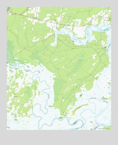
Pritchardville, SC USGS Topographic Map
Click on map above to begin viewing in our Map Viewer.

This topographic map contains these locations and features:
Feature Name Type Latitude Longitude GNIS ID View Map
Bellinger Hill School (historical)SchoolN32.1705°W80.9826°1241327View Map
Bluff IslandIslandN32.1599°W80.9107°1220827View Map
Bluffton CemeteryCemeteryN32.2371°W80.8765°1220834View Map
Bluffton Elementary SchoolSchoolN32.2473°W80.8983°2486537View Map
Bluffton Township Fire District Station 31BuildingN32.2380°W80.9669°2368374View Map
Coleman IslandIslandN32.1491°W80.9490°1221678View Map
Cook Landing CemeteryCemeteryN32.1944°W80.9998°1221724View Map
Cooper RiverChannelN32.1419°W80.8882°1221741View Map
Crane IslandIslandN32.2277°W80.8965°1228038View Map
Cummingsville CemeteryCemeteryN32.1422°W80.9892°2083205View Map
Cummingsville CemeteryCemeteryN32.1422°W80.9892°2083229View Map
Doughboy IslandIslandN32.1377°W80.9351°1222077View Map
Glasgow LandingPopulated PlaceN32.1355°W80.9909°1231319View Map
Good Hope LandingPopulated PlaceN32.1880°W80.9907°1231331View Map
H E McCracken Middle SchoolSchoolN32.2470°W80.9006°1237229View Map
Jack Crow IslandIslandN32.1572°W80.8846°1223478View Map
Long IslandIslandN32.1477°W80.9143°1224168View Map
May River NeckCapeN32.2013°W80.9387°1237278View Map
Maye River Baptist ChurchChurchN32.2466°W80.9759°1246569View Map
Mile SwampSwampN32.2121°W80.9971°1237283View Map
Moreland CemeteryCemeteryN32.1774°W80.8912°1224645View Map
Mount Zion ChurchChurchN32.1591°W80.9915°1249699View Map
Page IslandIslandN32.1322°W80.8982°1225273View Map
Palmetto BluffPopulated PlaceN32.2080°W80.8843°1225279View Map
Pilgrim ChurchChurchN32.1410°W80.9898°1250085View Map
PritchardvillePopulated PlaceN32.2380°W80.9643°1225679View Map
Rose Dew CreekStreamN32.2252°W80.9246°1250466View Map
Saint Matthews ChurchChurchN32.2430°W80.9893°1226211View Map
Shad CemeteryCemeteryN32.1474°W80.9982°1226511View Map
Shoe Quarter SwampSwampN32.2085°W80.9540°1237388View Map
Stoney School (historical)SchoolN32.2344°W80.9434°1237400View Map
Stony CreekStreamN32.2244°W80.9393°1226915View Map
Town of BlufftonCivilN32.2131°W80.9316°2405288View Map
Union Camp Pond Dam D-2939DamN32.2152°W80.9215°1239561View Map

Note: Coordinates in the location and feature list above are referenced to NAD83 datum.


Copyright (C) 2008-2025 Ryan Niemi / Sunset Dynamics ... All Rights Reserved