TopoQuest Logo
Do you find TopoQuest useful?
Help keep TopoQuest running and adding new maps/features by donating!
Bitcoin:  19c7KJd3qBynnjoSw5npx9KScwjBe4ifkT
Litecoin:  LXs6TkuXGGXo1vDsWCkWVdjQX94eUKd6ui
Home View Maps Find Maps Find Places Resources & Links


Jasper, South Carolina Topographic Map

USGS Map Title: Jasper, SC
USGS Map MRC: 32080C8
DRG (GeoTIFF) Download: o32080c8.tif


Neighboring USGS Topographic Map Quads:


  Tillman, SC  
32081D1
 

  Ridgeland, SC  
32080D8
 

  Laurel Bay, SC  
32080D7
 

  Hardeeville, SC  
32081C1
 

  Jasper, SC  
32080C8
 

  Spring Island, SC  
32080C7


  Pritchardville, SC  
32080B8
 

  Bluffton, SC  
32080B7


Map MRC Location:

N33°
W81°
N33°
W80°
H8 H7 H6 H5 H4 H3 H2 H1
G8 G7 G6 G5 G4 G3 G2 G1
F8 F7 F6 F5 F4 F3 F2 F1
E8 E7 E6 E5 E4 E3 E2 E1
D8 D7 D6 D5 D4 D3 D2 D1
C8 C7 C6 C5 C4 C3 C2 C1
B8 B7 B6 B5 B4 B3 B2 B1
A8 A7 A6 A5 A4 A3 A2 A1
N32°
W81°
N32°
W80°

Jasper, SC USGS 1:24K Topographic Map Preview:
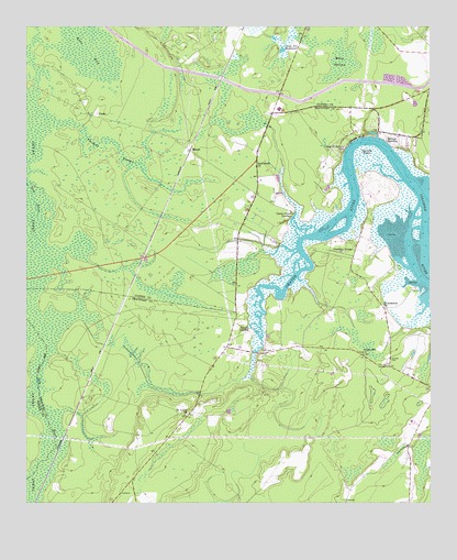
Jasper, SC USGS Topographic Map
Click on map above to begin viewing in our Map Viewer.

This topographic map contains these locations and features:
Feature Name Type Latitude Longitude GNIS ID View Map
Baileys LandingPopulated PlaceN32.3460°W80.8873°1231022View Map
Barrell LandingPopulated PlaceN32.2952°W80.9307°1253464View Map
Beaufort - Jasper Academy for Career ExcellenceSchoolN32.3537°W80.9216°2486545View Map
Bethlehem Baptist ChurchChurchN32.3385°W80.9287°1246819View Map
Bluffton - Okatie Outpatient CenterHospitalN32.2931°W80.9403°2640124View Map
Bluffton Fire Department Station 34BuildingN32.2971°W80.9488°2368424View Map
Bluffton Fire Department Station 35BuildingN32.2913°W80.9003°2368423View Map
Bluffton High SchoolSchoolN32.2515°W80.8988°2486536View Map
Bluffton Police DepartmentBuildingN32.2736°W80.9192°2334849View Map
Buckwalter Commons Industrial ParkLocaleN32.2837°W80.9119°2489475View Map
Camp Saint Marys ChurchChurchN32.3435°W80.9018°1247125View Map
ChelseaPopulated PlaceN32.3544°W80.8882°1237161View Map
Cherry Point LandingPopulated PlaceN32.3263°W80.9171°1231163View Map
Cross Episcopal SchoolSchoolN32.2640°W80.9070°2486539View Map
Garrets PointCapeN32.3419°W80.8948°1222653View Map
Golf Club At Rose HillLocaleN32.2769°W80.8869°2490018View Map
Great SwampSwampN32.2983°W80.9959°1222855View Map
Indian Hill ChurchChurchN32.2891°W80.8957°1223443View Map
Island West Golf CourseLocaleN32.2824°W80.9210°2490024View Map
JasperPopulated PlaceN32.3430°W80.9493°1227923View Map
Jasper County Fire Department Cherry PointBuildingN32.3282°W80.9443°2578800View Map
Jaxville CemeteryCemeteryN32.2877°W80.8873°1223518View Map
Kato BaySwampN32.3685°W80.9807°1223694View Map
Middleton Swamp (historical)SwampN32.2646°W80.9268°1237281View Map
New River Center for CommerceLocaleN32.3098°W80.9714°2489501View Map
Okatee BluffCliffN32.3458°W80.8979°1249944View Map
Okatee RiverStreamN32.3349°W80.8809°1249946View Map
OkatiePopulated PlaceN32.3521°W80.9782°1231612View Map
Okatie Elementary SchoolSchoolN32.3235°W80.9267°2486538View Map
Okatie Monkey FarmLocaleN32.3169°W80.9118°1237297View Map
Okatie School (historical)SchoolN32.2885°W80.8951°1237298View Map
Pinckney ColonyPopulated PlaceN32.3174°W80.8979°1231653View Map
Rose Hill Country ClubLocaleN32.2766°W80.8874°2490053View Map
Rose Hill PlantationLocaleN32.2835°W80.8821°1237351View Map
Saint Andrews ChurchChurchN32.3021°W80.8898°1226091View Map
Saint Lukes ChurchChurchN32.2735°W80.9501°1250569View Map
Sandy Hill BackwaterLakeN32.3691°W80.9206°1226364View Map
South Carolina Noname 07004 D-2932 DamDamN32.3452°W80.8932°1238817View Map
South Carolina Noname 27008 D-2589 DamDamN32.3719°W80.9248°1238748View Map
Sport Bridge School (historical)SchoolN32.3146°W80.9343°1237395View Map
Thomas SwampSwampN32.3449°W80.9748°1227098View Map
WBEU-AM (Hardeeville)TowerN32.3310°W80.9382°1252366View Map
Whig SwampSwampN32.3677°W80.9026°1227522View Map
WYKZ-FM (Beaufort)TowerN32.3308°W80.9384°1252447View Map

Note: Coordinates in the location and feature list above are referenced to NAD83 datum.


Copyright (C) 2008-2025 Ryan Niemi / Sunset Dynamics ... All Rights Reserved