TopoQuest Logo
Do you find TopoQuest useful?
Help keep TopoQuest running and adding new maps/features by donating!
Bitcoin:  19c7KJd3qBynnjoSw5npx9KScwjBe4ifkT
Litecoin:  LXs6TkuXGGXo1vDsWCkWVdjQX94eUKd6ui
Home View Maps Find Maps Find Places Resources & Links


Spring Island, South Carolina Topographic Map

USGS Map Title: Spring Island, SC
USGS Map MRC: 32080C7
DRG (GeoTIFF) Download: o32080c7.tif


Neighboring USGS Topographic Map Quads:


  Ridgeland, SC  
32080D8
 

  Laurel Bay, SC  
32080D7
 

  Beaufort, SC  
32080D6
 

  Jasper, SC  
32080C8
 

  Spring Island, SC  
32080C7
 

  Parris Island, SC  
32080C6
 

  Pritchardville, SC  
32080B8
 

  Bluffton, SC  
32080B7
 

  Hilton Head, SC  
32080B6


Map MRC Location:

N33°
W81°
N33°
W80°
H8 H7 H6 H5 H4 H3 H2 H1
G8 G7 G6 G5 G4 G3 G2 G1
F8 F7 F6 F5 F4 F3 F2 F1
E8 E7 E6 E5 E4 E3 E2 E1
D8 D7 D6 D5 D4 D3 D2 D1
C8 C7 C6 C5 C4 C3 C2 C1
B8 B7 B6 B5 B4 B3 B2 B1
A8 A7 A6 A5 A4 A3 A2 A1
N32°
W81°
N32°
W80°

Spring Island, SC USGS 1:24K Topographic Map Preview:
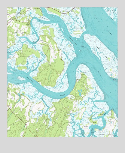
Spring Island, SC USGS Topographic Map
Click on map above to begin viewing in our Map Viewer.

This topographic map contains these locations and features:
Feature Name Type Latitude Longitude GNIS ID View Map
Belfair School (historical)SchoolN32.2616°W80.8529°1237138View Map
Bellinger NeckCapeN32.3705°W80.8504°1220484View Map
Big Harry IslandIslandN32.2583°W80.7865°1220701View Map
Bluffton DivisionCivilN32.2566°W80.8632°1938204View Map
Bluffton Fire Department ChelseaBuildingN32.3509°W80.8588°2368162View Map
Callawassie CreekStreamN32.3113°W80.8515°1221207View Map
Callawassie IslandIslandN32.3266°W80.8557°1247094View Map
Callawassie Island Club HouseLocaleN32.3292°W80.8551°2489829View Map
Carolina House of BlufftonBuildingN32.2724°W80.8684°2489920View Map
Chechessee CreekStreamN32.3616°W80.8237°1221530View Map
Chechessee PointCapeN32.3641°W80.8315°1221529View Map
Cherry Point Wastewater Treatment PlantLocaleN32.3660°W80.8686°2490495View Map
Colleton NeckCapeN32.3077°W80.7882°1221684View Map
Colleton RiverStreamN32.3252°W80.7909°1247344View Map
Copp LandingPopulated PlaceN32.3063°W80.8443°1231195View Map
Corn IslandIslandN32.2721°W80.7684°1221761View Map
Crane IslandIslandN32.3069°W80.8596°1221819View Map
Daws IslandIslandN32.3280°W80.7634°1221944View Map
EdwardsLocaleN32.3327°W80.8187°1244050View Map
Foot PointCapeN32.3088°W80.7882°1228039View Map
Foot Point PlantationLocaleN32.2741°W80.8037°1237196View Map
Foot Point School (historical)SchoolN32.2758°W80.8134°1237197View Map
Fripp LandingPopulated PlaceN32.3594°W80.8498°1244057View Map
G G Dowling BridgeBridgeN32.3746°W80.8346°1237203View Map
Hardeeville Church Road PlantLocaleN32.3662°W80.8685°2490496View Map
Hog Bluff PlantationLocaleN32.2535°W80.8009°1237244View Map
Little Harry IslandIslandN32.2658°W80.7798°1223997View Map
Low Country Plaza Shopping CenterLocaleN32.2591°W80.8526°1237269View Map
Manigault NeckCapeN32.3574°W80.8682°1246521View Map
Marine Railway Pond Dam D-2942DamN32.2885°W80.8598°1239559View Map
Pinckney Island National Wildlife RefugeParkN32.2541°W80.7698°2765451View Map
Pinckney Island School (historical)SchoolN32.2508°W80.7612°1237316View Map
Pinckney LandingPopulated PlaceN32.3424°W80.8393°1231654View Map
Pinckney NeckCapeN32.2705°W80.7576°1225427View Map
Rose IslandIslandN32.3533°W80.7973°1226026View Map
Saint Lukes ChurchChurchN32.3638°W80.8693°1226171View Map
Sawmill CreekStreamN32.2913°W80.8329°1226424View Map
Shell Point Census Designated PlaceCensusN32.3744°W80.7524°2402847View Map
South Carolina Noname 07001 Dam Number One D-2940DamN32.2919°W80.8615°1242497View Map
South Carolina Noname 07001 Dam Number Two D-2941DamN32.2919°W80.8615°1242499View Map
Spring IslandIslandN32.3305°W80.8251°1226826View Map
Spring Island School (historical)SchoolN32.3277°W80.8268°1237396View Map
Victoria BluffCliffN32.2880°W80.8109°1237410View Map
Victoria BluffCliffN32.2974°W80.7993°1244049View Map
Young Zion ChurchChurchN32.2630°W80.8687°1227733View Map

Note: Coordinates in the location and feature list above are referenced to NAD83 datum.


Copyright (C) 2008-2024 Ryan Niemi / Sunset Dynamics ... All Rights Reserved