TopoQuest Logo
Do you find TopoQuest useful?
Help keep TopoQuest running and adding new maps/features by donating!
Bitcoin:  19c7KJd3qBynnjoSw5npx9KScwjBe4ifkT
Litecoin:  LXs6TkuXGGXo1vDsWCkWVdjQX94eUKd6ui
Home View Maps Find Maps Find Places Resources & Links


Protem SW, Missouri Topographic Map

USGS Map Title: Protem SW, MO
USGS Map MRC: 36092E8
DRG (GeoTIFF) Download: o36092e8.tif


Neighboring USGS Topographic Map Quads:


  Forsyth, MO  
36093F1
 

  Hilda, MO  
36092F8
 

  Protem NE, MO  
36092F7
 

  Mincy, MO  
36093E1
 

  Protem SW, MO  
36092E8
 

  Protem, MO  
36092E7
 

  Omaha NE, AR  
36093D1
 

  Diamond City, AR  
36092D8
 

  Peel, AR  
36092D7


Map MRC Location:

N37°
W93°
N37°
W92°
H8 H7 H6 H5 H4 H3 H2 H1
G8 G7 G6 G5 G4 G3 G2 G1
F8 F7 F6 F5 F4 F3 F2 F1
E8 E7 E6 E5 E4 E3 E2 E1
D8 D7 D6 D5 D4 D3 D2 D1
C8 C7 C6 C5 C4 C3 C2 C1
B8 B7 B6 B5 B4 B3 B2 B1
A8 A7 A6 A5 A4 A3 A2 A1
N36°
W93°
N36°
W92°

Protem SW, MO USGS 1:24K Topographic Map Preview:
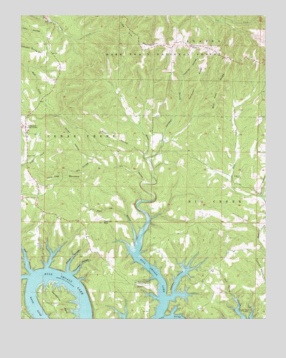
Protem SW, MO USGS Topographic Map
Click on map above to begin viewing in our Map Viewer.

This topographic map contains these locations and features:
Feature Name Type Latitude Longitude GNIS ID View Map
Bright Elbow Ranch Landing Field (historical)AirportN36.5140°W92.9385°753937View Map
Buck HollowValleyN36.5678°W92.9366°749084View Map
Cardwell HollowValleyN36.5665°W92.9355°749213View Map
Cardwell RidgeRidgeN36.5981°W92.9093°749214View Map
Cedar Creek CemeteryCemeteryN36.5670°W92.9971°749290View Map
Cedar Creek Volunteer Fire Department Station 1BuildingN36.5745°W92.9969°2620292View Map
CedarcreekPopulated PlaceN36.5790°W92.9977°749282View Map
Cedarcreek Post OfficePost OfficeN36.5805°W92.9973°2782927View Map
Clemens HollowValleyN36.5103°W92.9218°749382View Map
Dabbs CreekStreamN36.6240°W92.9896°749560View Map
Dry HollowValleyN36.5565°W92.9363°749725View Map
Elbow CreekStreamN36.5009°W92.9299°749809View Map
Elm HollowValleyN36.5192°W92.9946°749830View Map
Girten HollowValleyN36.5656°W92.9635°750045View Map
GroomLocaleN36.5578°W92.9938°733650View Map
Hankins CemeteryCemeteryN36.5584°W92.8885°750215View Map
Hankins HollowValleyN36.5998°W92.9168°750216View Map
Hoosier BranchStreamN36.5490°W92.8757°750383View Map
Horsehoe BendBendN36.5065°W92.9818°750398View Map
Lone Tree MountainSummitN36.5603°W92.9796°750842View Map
Mill Trail RidgeRidgeN36.5940°W92.8982°751088View Map
Poor Joe BaldSummitN36.5395°W92.9585°751710View Map
Poor Joe HollowValleyN36.5290°W92.9407°751711View Map
Ray CemeteryCemeteryN36.5028°W92.9346°751812View Map
Rhodes School (historical)SchoolN36.5801°W92.9374°733652View Map
Sunny Side School (historical)SchoolN36.5215°W92.9530°733651View Map
Thornton HollowValleyN36.5187°W92.9746°752538View Map
White Oak HollowValleyN36.5173°W92.9963°752858View Map
Woods HollowValleyN36.5192°W92.9763°752974View Map
Wyman ChurchChurchN36.6117°W92.9124°752987View Map

Note: Coordinates in the location and feature list above are referenced to NAD83 datum.


Copyright (C) 2008-2024 Ryan Niemi / Sunset Dynamics ... All Rights Reserved