TopoQuest Logo
Do you find TopoQuest useful?
Help keep TopoQuest running and adding new maps/features by donating!
Bitcoin:  19c7KJd3qBynnjoSw5npx9KScwjBe4ifkT
Litecoin:  LXs6TkuXGGXo1vDsWCkWVdjQX94eUKd6ui
Home View Maps Find Maps Find Places Resources & Links


Pryor Mountain, Texas Topographic Map

USGS Map Title: Pryor Mountain, TX
USGS Map MRC: 31095F2
DRG (GeoTIFF) Download: o31095f2.tif


Neighboring USGS Topographic Map Quads:


  Maydelle, TX  
31095G3
 

  Rusk, TX  
31095G2
 

  Atoy, TX  
31095G1
 

  Denson Springs, TX  
31095F3
 

  Pryor Mountain, TX  
31095F2
 

  Alto, TX  
31095F1
 

  Augusta, TX  
31095E3
 

  Weches, TX  
31095E2
 

  Forest, TX  
31095E1


Map MRC Location:

N32°
W96°
N32°
W95°
H8 H7 H6 H5 H4 H3 H2 H1
G8 G7 G6 G5 G4 G3 G2 G1
F8 F7 F6 F5 F4 F3 F2 F1
E8 E7 E6 E5 E4 E3 E2 E1
D8 D7 D6 D5 D4 D3 D2 D1
C8 C7 C6 C5 C4 C3 C2 C1
B8 B7 B6 B5 B4 B3 B2 B1
A8 A7 A6 A5 A4 A3 A2 A1
N31°
W96°
N31°
W95°

Pryor Mountain, TX USGS 1:24K Topographic Map Preview:
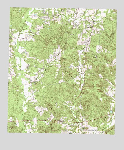
Pryor Mountain, TX USGS Topographic Map
Click on map above to begin viewing in our Map Viewer.

This topographic map contains these locations and features:
Feature Name Type Latitude Longitude GNIS ID View Map
Adams ChapelChurchN31.6746°W95.2252°1350871View Map
Berry CemeteryCemeteryN31.7188°W95.2486°1351917View Map
Big HillSummitN31.6299°W95.2466°1352080View Map
Bird HollowValleyN31.6349°W95.1352°1352222View Map
Black BranchStreamN31.7382°W95.1816°1372596View Map
Box CemeteryCemeteryN31.6788°W95.2183°1352765View Map
BulahPopulated PlaceN31.6855°W95.2169°1379473View Map
Campground ChurchChurchN31.6374°W95.1886°1353708View Map
Collins BranchStreamN31.6591°W95.2291°1354798View Map
Collins MountainSummitN31.6527°W95.2019°1354801View Map
Decker LakeReservoirN31.6479°W95.1297°1355797View Map
Decker Lake DamDamN31.6485°W95.1286°1855380View Map
Fain BranchStreamN31.7052°W95.1666°1357160View Map
Fowler HillSummitN31.6282°W95.2063°1357656View Map
Gibson MountainSummitN31.7002°W95.1583°1358000View Map
Hall BranchStreamN31.6388°W95.2147°1358661View Map
Hendon BranchStreamN31.7068°W95.1658°1359031View Map
Hendrick CemeteryCemeteryN31.6627°W95.2186°1359032View Map
Henry White MountainSummitN31.6824°W95.1422°1359047View Map
Holcomb CemeteryCemeteryN31.6602°W95.2438°1359392View Map
Holliday BranchStreamN31.6502°W95.1763°1359421View Map
Hudson ChapelPopulated PlaceN31.7316°W95.1530°1359779View Map
Jones BranchStreamN31.6955°W95.1677°1360375View Map
Jones MountainSummitN31.6960°W95.1861°1360405View Map
Lewis BranchStreamN31.6682°W95.1674°1361117View Map
Lone OakPopulated PlaceN31.7396°W95.1986°1380106View Map
Lynchs ChapelChurchN31.6335°W95.1774°1362000View Map
Manson BranchStreamN31.7118°W95.1252°1374793View Map
McCann CreekStreamN31.7391°W95.1719°1374834View Map
McCann SpringSpringN31.7387°W95.1533°1362374View Map
Merideth CreekStreamN31.6688°W95.2330°1362630View Map
Miller BranchStreamN31.6260°W95.1408°1362889View Map
Moseley CemeteryCemeteryN31.7474°W95.1788°1363189View Map
Nelson CemeteryCemeteryN31.7332°W95.1738°1363665View Map
Newton BranchStreamN31.6680°W95.2138°1363860View Map
Parks CemeteryCemeteryN31.7227°W95.2306°1364844View Map
Parks LakeReservoirN31.7345°W95.1743°1364846View Map
Pryor LakeReservoirN31.7297°W95.2047°1365832View Map
Pryor MountainSummitN31.7210°W95.1886°1365833View Map
Reagan MountainSummitN31.7257°W95.1813°1366084View Map
Round MountainSummitN31.7002°W95.1877°1366953View Map
Russell CemeteryCemeteryN31.7241°W95.1766°1367030View Map
Russell CemeteryCemeteryN31.7460°W95.1897°1367031View Map
Sand BranchStreamN31.6391°W95.2133°1367562View Map
Smith CemeteryCemeteryN31.6816°W95.1747°1368471View Map
Smith MountainSummitN31.6824°W95.1783°1368497View Map
Stevens BranchStreamN31.6796°W95.2166°1369178View Map
Sunshine MountainSummitN31.6760°W95.1519°1369424View Map
Thompson BranchStreamN31.6855°W95.1647°1369848View Map
Walnut BranchStreamN31.7249°W95.2380°1370800View Map
William Wise Oil FieldOilfieldN31.6913°W95.2036°1371557View Map
Woodall BranchStreamN31.7382°W95.1747°1371899View Map

Note: Coordinates in the location and feature list above are referenced to NAD83 datum.


Copyright (C) 2008-2024 Ryan Niemi / Sunset Dynamics ... All Rights Reserved