TopoQuest Logo
Do you find TopoQuest useful?
Help keep TopoQuest running and adding new maps/features by donating!
Bitcoin:  19c7KJd3qBynnjoSw5npx9KScwjBe4ifkT
Litecoin:  LXs6TkuXGGXo1vDsWCkWVdjQX94eUKd6ui
Home View Maps Find Maps Find Places Resources & Links


Weches, Texas Topographic Map

USGS Map Title: Weches, TX
USGS Map MRC: 31095E2
DRG (GeoTIFF) Download: o31095e2.tif


Neighboring USGS Topographic Map Quads:


  Denson Springs, TX  
31095F3
 

  Pryor Mountain, TX  
31095F2
 

  Alto, TX  
31095F1
 

  Augusta, TX  
31095E3
 

  Weches, TX  
31095E2
 

  Forest, TX  
31095E1
 

  Crockett NE, TX  
31095D3
 

  Ratcliff, TX  
31095D2
 

  Kennard NE, TX  
31095D1


Map MRC Location:

N32°
W96°
N32°
W95°
H8 H7 H6 H5 H4 H3 H2 H1
G8 G7 G6 G5 G4 G3 G2 G1
F8 F7 F6 F5 F4 F3 F2 F1
E8 E7 E6 E5 E4 E3 E2 E1
D8 D7 D6 D5 D4 D3 D2 D1
C8 C7 C6 C5 C4 C3 C2 C1
B8 B7 B6 B5 B4 B3 B2 B1
A8 A7 A6 A5 A4 A3 A2 A1
N31°
W96°
N31°
W95°

Weches, TX USGS 1:24K Topographic Map Preview:
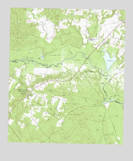
Weches, TX USGS Topographic Map
Click on map above to begin viewing in our Map Viewer.

This topographic map contains these locations and features:
Feature Name Type Latitude Longitude GNIS ID View Map
Allen BranchStreamN31.5835°W95.1627°1350993View Map
Bluff City (historical)Populated PlaceN31.5407°W95.1444°1377450View Map
Bluff CreekStreamN31.5377°W95.1480°1383387View Map
Bluff CreekStreamN31.5402°W95.1438°1352508View Map
Bodenhamer BranchStreamN31.5252°W95.1974°1383379View Map
Bodenhamer BranchStreamN31.5249°W95.1972°1352554View Map
Bog LakeLakeN31.5418°W95.1330°1383590View Map
Bog LakeLakeN31.5418°W95.1331°1352560View Map
Boggy Glade BranchStreamN31.5346°W95.1791°1383381View Map
Boggy Glade BranchStreamN31.5346°W95.1786°1352593View Map
Bowles CreekStreamN31.5799°W95.1672°1372693View Map
Bowles CreekStreamN31.5799°W95.1677°1383545View Map
Box CreekStreamN31.5813°W95.1786°1372698View Map
Brushy LakeLakeN31.5564°W95.1474°1353078View Map
Brushy LakeLakeN31.5782°W95.2197°1353079View Map
Butler BranchStreamN31.6105°W95.2116°1353419View Map
Caddoan Mounds State Historical ParkParkN31.5963°W95.1519°2028643View Map
Camp Creek School (historical)SchoolN31.5216°W95.1902°1377425View Map
Cedar CreekStreamN31.5646°W95.1424°1373009View Map
Chain of LakesLakeN31.5776°W95.2353°1354250View Map
Chain of LakesLakeN31.5780°W95.2349°1383596View Map
Collard LakeLakeN31.5419°W95.1379°1354784View Map
Collard LakeLakeN31.5421°W95.1374°1383589View Map
Coon PondLakeN31.5818°W95.2164°1354936View Map
Dan and Hannah McLean GravesCemeteryN31.5310°W95.2497°1377413View Map
Diboll Camp School (historical)SchoolN31.5407°W95.1374°1377414View Map
Duren LakeReservoirN31.5702°W95.1502°1862595View Map
Duren LakeLakeN31.5785°W95.1419°1383579View Map
Duren LakeLakeN31.5789°W95.1427°1356476View Map
Duren Lake DamDamN31.5702°W95.1502°1862594View Map
Easley CemeteryCemeteryN31.5613°W95.1772°1356563View Map
Easley CemeteryCemeteryN31.5613°W95.1774°1383585View Map
Easley ChapelPopulated PlaceN31.5532°W95.1805°1377449View Map
Ferrell Shingle Mill (historical)LocaleN31.5282°W95.1799°1377412View Map
First Weches School (historical)SchoolN31.5455°W95.2291°1377421View Map
Forman BranchStreamN31.5846°W95.1361°1357575View Map
Forman LakeLakeN31.5857°W95.1501°1357576View Map
Forman LakeLakeN31.5868°W95.1497°1383581View Map
Franklin CemeteryCemeteryN31.5410°W95.2305°1377422View Map
Franklin Church (historical)ChurchN31.5366°W95.2349°1377424View Map
Franklin School (historical)SchoolN31.5363°W95.2347°1377423View Map
Friendswood Public LibraryBuildingN31.5932°W95.2013°2014954View Map
George C Davis Archeological Site and MuseumLocaleN31.5935°W95.1552°1383578View Map
Hargrove LakeLakeN31.5611°W95.1429°1358793View Map
Hargrove LakeLakeN31.5610°W95.1430°1383587View Map
Horseshoe LakeLakeN31.5746°W95.2258°1359657View Map
Horseshoe LakeLakeN31.5741°W95.2248°1383598View Map
Indian Mound NurseryLocaleN31.5938°W95.1463°1384579View Map
Indian Mound NurseryLocaleN31.5941°W95.1463°1383576View Map
Kennedy Cemetery (historical)CemeteryN31.5621°W95.1780°1377418View Map
Kennedy CrossingCrossingN31.5818°W95.1722°1377416View Map
Krem LakeLakeN31.5749°W95.1644°1360767View Map
Krem LakeLakeN31.5752°W95.1644°1383582View Map
Mission LakeLakeN31.5485°W95.2355°1362971View Map
Mission LakeLakeN31.5485°W95.2357°1383591View Map
Mission Tejas State ParkParkN31.5466°W95.2341°1362976View Map
Mission Tejas State ParkParkN31.5463°W95.2349°1383592View Map
Mission Tejas State Park TrailTrailN31.5463°W95.2349°2033347View Map
Morning Star School (historical)SchoolN31.5505°W95.2236°1377420View Map
Musek BranchStreamN31.6221°W95.2269°1363513View Map
Neches Bluff CampgroundLocaleN31.5668°W95.1644°1383580View Map
Neches Bluff OverlookLocaleN31.5674°W95.1630°1363630View Map
Neches Bluff TrailTrailN31.5666°W95.1624°2032978View Map
Pearman LakeLakeN31.5788°W95.2297°1383595View Map
Pearman LakeLakeN31.5788°W95.2294°1364940View Map
Pepper TreeLocaleN31.5635°W95.1777°1377415View Map
Pole BranchStreamN31.5305°W95.1747°1365515View Map
Pole BranchStreamN31.5302°W95.1749°1383380View Map
Saint Thomas ChapelChurchN31.6149°W95.1277°1367325View Map
Saint Thomas ChapelChurchN31.6149°W95.1280°1383378View Map
San Pedro CreekStreamN31.5735°W95.2319°1383750View Map
San Pedro CreekStreamN31.5735°W95.2316°1375978View Map
Sawmill LakeLakeN31.5777°W95.1788°1367802View Map
Sawmill LakeLakeN31.5780°W95.1786°1383583View Map
Schoechler LakeLakeN31.5767°W95.2459°1367839View Map
Schoechler LakeLakeN31.5766°W95.2461°1383597View Map
Second Weches School (historical)SchoolN31.5416°W95.2316°1377417View Map
SH 21 BridgeBridgeN31.5813°W95.1722°1377411View Map
Sulphur CreekStreamN31.5382°W95.1274°1369360View Map
Texas A&M Experiment StationBuildingN31.5968°W95.1469°1383377View Map
WechesPopulated PlaceN31.5441°W95.2277°1385453View Map
Weches CemeteryCemeteryN31.5468°W95.2297°1377419View Map
Weches Volunteer Fire DepartmentBuildingN31.5437°W95.2281°2655404View Map
Weeping MaryPopulated PlaceN31.5968°W95.1597°1370986View Map
White Oak CreekStreamN31.6102°W95.1541°1383544View Map
White Oak CreekStreamN31.6107°W95.1536°1371394View Map

Note: Coordinates in the location and feature list above are referenced to NAD83 datum.


Copyright (C) 2008-2025 Ryan Niemi / Sunset Dynamics ... All Rights Reserved