TopoQuest Logo
Do you find TopoQuest useful?
Help keep TopoQuest running and adding new maps/features by donating!
Bitcoin:  19c7KJd3qBynnjoSw5npx9KScwjBe4ifkT
Litecoin:  LXs6TkuXGGXo1vDsWCkWVdjQX94eUKd6ui
Home View Maps Find Maps Find Places Resources & Links


Maydelle, Texas Topographic Map

USGS Map Title: Maydelle, TX
USGS Map MRC: 31095G3
DRG (GeoTIFF) Download: o31095g3.tif


Neighboring USGS Topographic Map Quads:


  Todd City, TX  
31095H4
 

  Jacksonville West, TX  
31095H3
 

  Jacksonville East, TX  
31095H2
 

  Neches, TX  
31095G4
 

  Maydelle, TX  
31095G3
 

  Rusk, TX  
31095G2
 

  Slocum, TX  
31095F4
 

  Denson Springs, TX  
31095F3
 

  Pryor Mountain, TX  
31095F2


Map MRC Location:

N32°
W96°
N32°
W95°
H8 H7 H6 H5 H4 H3 H2 H1
G8 G7 G6 G5 G4 G3 G2 G1
F8 F7 F6 F5 F4 F3 F2 F1
E8 E7 E6 E5 E4 E3 E2 E1
D8 D7 D6 D5 D4 D3 D2 D1
C8 C7 C6 C5 C4 C3 C2 C1
B8 B7 B6 B5 B4 B3 B2 B1
A8 A7 A6 A5 A4 A3 A2 A1
N31°
W96°
N31°
W95°

Maydelle, TX USGS 1:24K Topographic Map Preview:
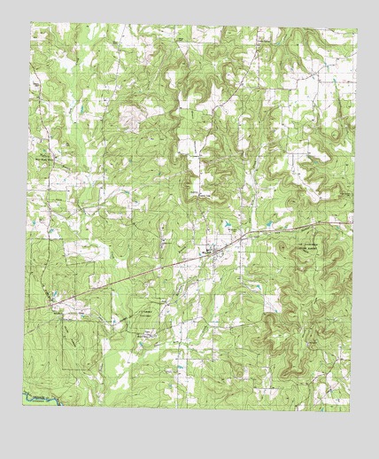
Maydelle, TX USGS Topographic Map
Click on map above to begin viewing in our Map Viewer.

This topographic map contains these locations and features:
Feature Name Type Latitude Longitude GNIS ID View Map
Berge CemeteryCemeteryN31.8704°W95.3188°1889927View Map
Brigman BranchStreamN31.7721°W95.3188°1352894View Map
Fairchild State ForestForestN31.7866°W95.3538°1373693View Map
Ghent MountainSummitN31.8427°W95.3147°1357983View Map
Gum CreekStreamN31.7877°W95.3413°1373947View Map
Holleman ChapelChurchN31.7624°W95.3158°1359418View Map
Holly Springs CemeteryCemeteryN31.8210°W95.2516°1359450View Map
JavaPopulated PlaceN31.7843°W95.3202°1379999View Map
MaydellePopulated PlaceN31.8007°W95.3024°1362318View Map
Maydelle Post OfficePost OfficeN31.8030°W95.3018°2732145View Map
Maydelle Volunteer Fire DepartmentBuildingN31.8021°W95.3024°2655285View Map
MewshawPopulated PlaceN31.7804°W95.3594°1380183View Map
Mount Comfort CemeteryCemeteryN31.8091°W95.2933°1363239View Map
Mount HopeSummitN31.7818°W95.2694°1363251View Map
Mount Hope CemeteryCemeteryN31.7721°W95.2672°1363254View Map
Mount Hope SchoolLocaleN31.7652°W95.2563°1363259View Map
Mount Hope Tract TrailTrailN31.8049°W95.2666°2033358View Map
Nature TrailTrailN31.7668°W95.3558°2033365View Map
One Arm CreekStreamN31.7585°W95.3399°1364548View Map
Pine Grove SchoolSchoolN31.8685°W95.3405°1365283View Map
Pleasant Grove ChurchChurchN31.8038°W95.3222°1365416View Map
Tillman CemeteryCemeteryN31.8552°W95.3691°1369943View Map
Union Grove ChurchChurchN31.8691°W95.2883°1370456View Map
Wallace BranchStreamN31.8243°W95.3499°1370783View Map
West Shady Grove CemeteryCemeteryN31.8366°W95.3686°1371218View Map
West Shady Grove ChurchChurchN31.8243°W95.3644°1371219View Map
Wilson ChapelChurchN31.8685°W95.3416°1889926View Map

Note: Coordinates in the location and feature list above are referenced to NAD83 datum.


Copyright (C) 2008-2025 Ryan Niemi / Sunset Dynamics ... All Rights Reserved