TopoQuest Logo
Do you find TopoQuest useful?
Help keep TopoQuest running and adding new maps/features by donating!
Bitcoin:  19c7KJd3qBynnjoSw5npx9KScwjBe4ifkT
Litecoin:  LXs6TkuXGGXo1vDsWCkWVdjQX94eUKd6ui
Home View Maps Find Maps Find Places Resources & Links


Big Canyon, Oregon Topographic Map

USGS Map Title: Big Canyon, OR
USGS Map MRC: 44118B7
DRG (GeoTIFF) Download: o44118b7.tif


Neighboring USGS Topographic Map Quads:


  Canyon Mountain, OR  
44118C8
 

  Pine Creek Mountain, OR  
44118C7
 

  Strawberry Mountain, OR  
44118C6
 

  Seneca, OR  
44118B8
 

  Big Canyon, OR  
44118B7
 

  Logan Valley West, OR  
44118B6
 

  Silvies, OR  
44118A8
 

  Jump-off Joe Mountain, OR  
44118A7
 

  Magpie Table, OR  
44118A6


Map MRC Location:

N45°
W119°
N45°
W118°
H8 H7 H6 H5 H4 H3 H2 H1
G8 G7 G6 G5 G4 G3 G2 G1
F8 F7 F6 F5 F4 F3 F2 F1
E8 E7 E6 E5 E4 E3 E2 E1
D8 D7 D6 D5 D4 D3 D2 D1
C8 C7 C6 C5 C4 C3 C2 C1
B8 B7 B6 B5 B4 B3 B2 B1
A8 A7 A6 A5 A4 A3 A2 A1
N44°
W119°
N44°
W118°

Big Canyon, OR USGS 1:24K Topographic Map Preview:
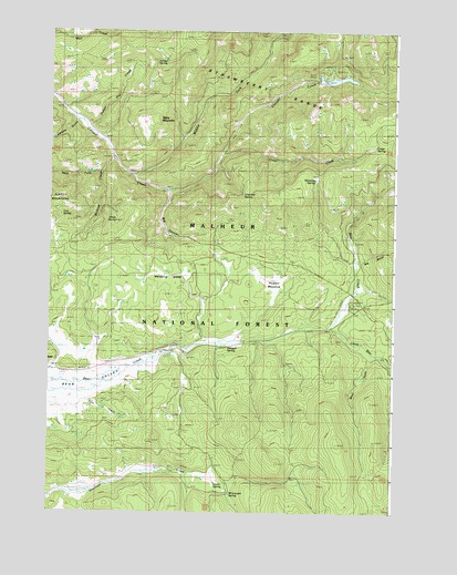
Big Canyon, OR USGS Topographic Map
Click on map above to begin viewing in our Map Viewer.

This topographic map contains these locations and features:
Feature Name Type Latitude Longitude GNIS ID View Map
Betum SpringSpringN44.2179°W118.8539°1132063View Map
Big BendValleyN44.1902°W118.7624°1137972View Map
Big CanyonValleyN44.2079°W118.8319°1117592View Map
Butterfly SpringSpringN44.2124°W118.7788°1118401View Map
Byron DitchCanalN44.1568°W118.8594°1129509View Map
Canyon Creek MeadowFlatN44.2374°W118.7724°1118581View Map
Canyon Creek Meadows DamDamN44.2370°W118.7787°1133481View Map
Canyon MeadowsLocaleN44.2402°W118.7758°1167262View Map
Canyon Meadows LakeLakeN44.2375°W118.7721°1132086View Map
Canyon Meadows Recreation SiteLocaleN44.2407°W118.7761°1926229View Map
Chamber SpringSpringN44.2075°W118.8054°1118807View Map
Crawford GulchValleyN44.2265°W118.8636°1140413View Map
Crazy CreekStreamN44.2179°W118.8122°1119524View Map
Crazy SpringSpringN44.2200°W118.7575°1119528View Map
Foster SpringSpringN44.1320°W118.8146°1120910View Map
Horse SpringSpringN44.2008°W118.8513°1122020View Map
Juniper SpringSpringN44.2415°W118.8374°1122615View Map
Little Bear CreekStreamN44.1735°W118.7722°1145089View Map
Little Rock SpringSpringN44.1785°W118.8677°1133912View Map
Lower Gap CreekStreamN44.2257°W118.8633°1125089View Map
Malheur National ForestForestN44.2494°W118.8577°1155108View Map
Middle Fork Canyon CreekStreamN44.2124°W118.8452°1146139View Map
Parish Cabin Recreation SiteLocaleN44.1799°W118.7655°1158415View Map
Pole CreekStreamN44.1538°W118.8613°1125520View Map
Powell MeadowFlatN44.1849°W118.7961°1125637View Map
Rock SpringSpringN44.1829°W118.8606°1126207View Map
Steagall SpringSpringN44.1678°W118.8105°1127554View Map
Table MountainSummitN44.2257°W118.8355°1127862View Map
Trail SpringSpringN44.2022°W118.8709°1128201View Map
Wendling GladeFlatN44.1863°W118.8261°1128801View Map
West Fork Little Bear CreekStreamN44.1668°W118.7580°1128857View Map
West Fork Wickiup CreekStreamN44.2132°W118.8555°1152124View Map
Whitewater SpringSpringN44.1298°W118.8089°1129016View Map
Wickiup CreekStreamN44.2168°W118.8508°1129030View Map
Wickiup Recreation SiteLocaleN44.2165°W118.8524°1167263View Map

Note: Coordinates in the location and feature list above are referenced to NAD83 datum.


Copyright (C) 2008-2025 Ryan Niemi / Sunset Dynamics ... All Rights Reserved