TopoQuest Logo
Do you find TopoQuest useful?
Help keep TopoQuest running and adding new maps/features by donating!
Bitcoin:  19c7KJd3qBynnjoSw5npx9KScwjBe4ifkT
Litecoin:  LXs6TkuXGGXo1vDsWCkWVdjQX94eUKd6ui
Home View Maps Find Maps Find Places Resources & Links


Purcell Mountain, Washington Topographic Map

USGS Map Title: Purcell Mountain, WA
USGS Map MRC: 46121E7
DRG (GeoTIFF) Download: o46121e7.tif


Neighboring USGS Topographic Map Quads:


  Sawtooth Ridge, WA  
46121F8
 

  Wahpenayo Peak, WA  
46121F7
 

  Tatoosh Lakes, WA  
46121F6
 

  Randle, WA  
46121E8
 

  Purcell Mountain, WA  
46121E7
 

  Packwood, WA  
46121E6
 

  Greenhorn Buttes, WA  
46121D8
 

  Tower Rock, WA  
46121D7
 

  Blue Lake, WA  
46121D6


Map MRC Location:

N47°
W122°
N47°
W121°
H8 H7 H6 H5 H4 H3 H2 H1
G8 G7 G6 G5 G4 G3 G2 G1
F8 F7 F6 F5 F4 F3 F2 F1
E8 E7 E6 E5 E4 E3 E2 E1
D8 D7 D6 D5 D4 D3 D2 D1
C8 C7 C6 C5 C4 C3 C2 C1
B8 B7 B6 B5 B4 B3 B2 B1
A8 A7 A6 A5 A4 A3 A2 A1
N46°
W122°
N46°
W121°

Purcell Mountain, WA USGS 1:24K Topographic Map Preview:
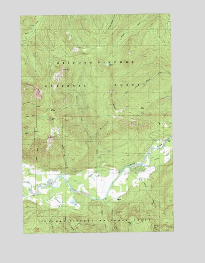
Purcell Mountain, WA USGS Topographic Map
Click on map above to begin viewing in our Map Viewer.

This topographic map contains these locations and features:
Feature Name Type Latitude Longitude GNIS ID View Map
Burton CreekStreamN46.5383°W121.7779°1517139View Map
Cockscomb MountainSummitN46.5548°W121.8537°1517908View Map
CoraPopulated PlaceN46.5359°W121.7901°1530583View Map
Cora BridgeBridgeN46.5348°W121.7943°1518100View Map
Cougar CreekStreamN46.5179°W121.8115°1518159View Map
Cunningham CreekStreamN46.5171°W121.8445°1518413View Map
Davis CreekStreamN46.5259°W121.8254°1518501View Map
Davis MountainSummitN46.5737°W121.8018°1531433View Map
Davis Mountain TrailTrailN46.5634°W121.8093°1531434View Map
Garrett CreekStreamN46.5373°W121.7879°1519907View Map
Hopkin CreekStreamN46.5321°W121.8415°1520911View Map
Karr CreekStreamN46.5512°W121.7659°1528580View Map
Kilborn CreekStreamN46.5187°W121.8101°1521659View Map
Kilborn SpringSpringN46.5059°W121.7834°1521660View Map
Left Fork Owens CreekStreamN46.5015°W121.8345°1521997View Map
Little ParadiseFlatN46.5704°W121.8520°1522281View Map
Maple Leaf CampgroundLocaleN46.5351°W121.8245°1522695View Map
Mullins CreekStreamN46.5207°W121.8143°1528478View Map
Owens CreekStreamN46.5168°W121.8395°1524112View Map
Pompey PeakSummitN46.5012°W121.7670°1524563View Map
Pompey Peak LookoutLocaleN46.5012°W121.7670°1530209View Map
Prairie MountainSummitN46.5651°W121.8526°1524617View Map
Purcell MountainSummitN46.5934°W121.8426°1524696View Map
Purcell Mountain TrailTrailN46.5548°W121.8384°1524697View Map
Purcell SloughGutN46.5287°W121.8537°1524698View Map
Right Fork Owens CreekStreamN46.5168°W121.8395°1525048View Map
The PotholeBasinN46.5698°W121.7856°1527064View Map
Whalehead RidgeRidgeN46.5846°W121.8734°1528016View Map
Willame LakeLakeN46.5962°W121.8047°1528162View Map
Willame TrailTrailN46.6046°W121.7781°1528163View Map

Note: Coordinates in the location and feature list above are referenced to NAD83 datum.


Copyright (C) 2008-2025 Ryan Niemi / Sunset Dynamics ... All Rights Reserved