TopoQuest Logo
Do you find TopoQuest useful?
Help keep TopoQuest running and adding new maps/features by donating!
Bitcoin:  19c7KJd3qBynnjoSw5npx9KScwjBe4ifkT
Litecoin:  LXs6TkuXGGXo1vDsWCkWVdjQX94eUKd6ui
Home View Maps Find Maps Find Places Resources & Links


Tatoosh Lakes, Washington Topographic Map

USGS Map Title: Tatoosh Lakes, WA
USGS Map MRC: 46121F6
DRG (GeoTIFF) Download: o46121f6.tif


Neighboring USGS Topographic Map Quads:


  Mount Rainier West, WA  
46121G7
 

  Mount Rainier East, WA  
46121G6
 

  Chinook Pass, WA  
46121G5
 

  Wahpenayo Peak, WA  
46121F7
 

  Tatoosh Lakes, WA  
46121F6
 

  Ohanapecosh Hot Springs, WA  
46121F5
 

  Purcell Mountain, WA  
46121E7
 

  Packwood, WA  
46121E6
 

  Packwood Lake, WA  
46121E5


Map MRC Location:

N47°
W122°
N47°
W121°
H8 H7 H6 H5 H4 H3 H2 H1
G8 G7 G6 G5 G4 G3 G2 G1
F8 F7 F6 F5 F4 F3 F2 F1
E8 E7 E6 E5 E4 E3 E2 E1
D8 D7 D6 D5 D4 D3 D2 D1
C8 C7 C6 C5 C4 C3 C2 C1
B8 B7 B6 B5 B4 B3 B2 B1
A8 A7 A6 A5 A4 A3 A2 A1
N46°
W122°
N46°
W121°

Tatoosh Lakes, WA USGS 1:24K Topographic Map Preview:
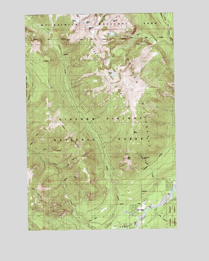
Tatoosh Lakes, WA USGS Topographic Map
Click on map above to begin viewing in our Map Viewer.

This topographic map contains these locations and features:
Feature Name Type Latitude Longitude GNIS ID View Map
Blue LakeLakeN46.7381°W121.6780°1516692View Map
Boulder CreekStreamN46.6523°W121.7209°1516822View Map
Boundary PeakSummitN46.7412°W121.6976°1516873View Map
Bum SpringsSpringN46.6810°W121.6616°1517089View Map
Butter CreekStreamN46.6263°W121.6590°1534054View Map
Butter Creek Research Natural AreaAreaN46.7298°W121.7281°1529165View Map
Butter PeakSummitN46.6657°W121.6669°1529909View Map
Dixon CreekStreamN46.6284°W121.7006°1518818View Map
Dixon MountainSummitN46.6678°W121.7066°1518819View Map
Evergreen CemeteryCemeteryN46.6281°W121.6758°1529166View Map
Hinkle Tinkle CreekStreamN46.6473°W121.6306°1520816View Map
Hinkle Tinkle TrailTrailN46.6654°W121.6531°1529644View Map
Lake CreekStreamN46.6373°W121.6434°1521840View Map
Lewis County Fire District 10 Station 2BuildingN46.6322°W121.6661°2643827View Map
Maggie CreekStreamN46.6729°W121.7487°1522632View Map
Rock CreekStreamN46.6693°W121.7406°1525112View Map
Stevens CreekStreamN46.7459°W121.6354°1533622View Map
Stevens PeakSummitN46.7460°W121.6769°1526554View Map
Taos CreekStreamN46.7309°W121.6270°1526935View Map
Tatoosh LakesLakeN46.7145°W121.6770°1526950View Map
Tatoosh LookoutLocaleN46.7059°W121.6645°1526951View Map
Tatoosh RangeRangeN46.7216°W121.6863°1533630View Map
Tatoosh RidgeRidgeN46.7223°W121.6618°1534088View Map
Tatoosh Ridge LookoutLocaleN46.7062°W121.6645°1530263View Map
Tatoosh TrailTrailN46.6729°W121.6651°1526952View Map
Tatoosh TrailheadLocaleN46.6687°W121.6345°1529645View Map
Tatoosh WildernessReserveN46.7040°W121.6672°1528731View Map
Teardrop CreekStreamN46.6601°W121.7231°1526968View Map
The BurnAreaN46.7457°W121.6306°1529177View Map
Unicorn GlacierGlacierN46.7454°W121.7073°1527605View Map
Unicorn PeakSummitN46.7449°W121.7011°1527606View Map

Note: Coordinates in the location and feature list above are referenced to NAD83 datum.


Copyright (C) 2008-2024 Ryan Niemi / Sunset Dynamics ... All Rights Reserved