TopoQuest Logo
Do you find TopoQuest useful?
Help keep TopoQuest running and adding new maps/features by donating!
Bitcoin:  19c7KJd3qBynnjoSw5npx9KScwjBe4ifkT
Litecoin:  LXs6TkuXGGXo1vDsWCkWVdjQX94eUKd6ui
Home View Maps Find Maps Find Places Resources & Links


Queens Hill Lake, Mississippi Topographic Map

USGS Map Title: Queens Hill Lake, MS
USGS Map MRC: 32090D5
DRG (GeoTIFF) Download: o32090d5.tif


Neighboring USGS Topographic Map Quads:


  Eldorado, MS  
32090E6
 

  Phoenix, MS  
32090E5
 

  Coxs Ferry, MS  
32090E4
 

  Oak Ridge, MS  
32090D6
 

  Queens Hill Lake, MS  
32090D5
 

  Brownsville, MS  
32090D4
 

  Bovina, MS  
32090C6
 

  Edwards, MS  
32090C5
 

  Raymond, MS  
32090C4


Map MRC Location:

N33°
W91°
N33°
W90°
H8 H7 H6 H5 H4 H3 H2 H1
G8 G7 G6 G5 G4 G3 G2 G1
F8 F7 F6 F5 F4 F3 F2 F1
E8 E7 E6 E5 E4 E3 E2 E1
D8 D7 D6 D5 D4 D3 D2 D1
C8 C7 C6 C5 C4 C3 C2 C1
B8 B7 B6 B5 B4 B3 B2 B1
A8 A7 A6 A5 A4 A3 A2 A1
N32°
W91°
N32°
W90°

Queens Hill Lake, MS USGS 1:24K Topographic Map Preview:
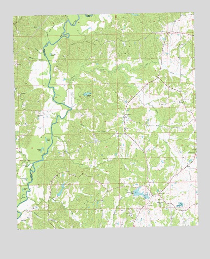
Queens Hill Lake, MS USGS Topographic Map
Click on map above to begin viewing in our Map Viewer.

This topographic map contains these locations and features:
Feature Name Type Latitude Longitude GNIS ID View Map
Adams BayouStreamN32.4743°W90.6015°666148View Map
Anderson School (historical)SchoolN32.4149°W90.5926°688193View Map
Birdsong CemeteryCemeteryN32.4351°W90.5348°667182View Map
Birdsong Ferry (historical)CrossingN32.4440°W90.5884°686303View Map
Buck CreekStreamN32.4888°W90.6015°667728View Map
Bushs Ferry (historical)CrossingN32.4810°W90.6043°707644View Map
Butts CreekStreamN32.4974°W90.5868°667869View Map
Cameron LakeLakeN32.4046°W90.6179°667961View Map
Cashmans Lake DamDamN32.3785°W90.5818°681270View Map
Club LakeReservoirN32.3876°W90.5124°668618View Map
Cox CreekStreamN32.4679°W90.5540°668916View Map
Crossed Arrow Lakes DamDamN32.3951°W90.5968°681303View Map
Gaddis Farms Lake DamDamN32.3918°W90.5084°681295View Map
Gillespie LakeLakeN32.4771°W90.5997°670386View Map
Good Hope ChurchChurchN32.4329°W90.5493°670477View Map
Greers Lake DamDamN32.4485°W90.5668°681378View Map
Halls CreekStreamN32.4299°W90.5993°670845View Map
Harris CemeteryCemeteryN32.4574°W90.6243°670970View Map
Henry-Grant CemeteryCemeteryN32.4418°W90.6095°671116View Map
Horseshoe LakeLakeN32.4128°W90.6162°671492View Map
Ingraham (historical)LocaleN32.4335°W90.5820°688408View Map
J B White Pond DamDamN32.4618°W90.5001°681401View Map
James Plantation (historical)LocaleN32.4390°W90.6015°707657View Map
Jones FordCrossingN32.4157°W90.6065°707659View Map
Little Kingdom Come Church (historical)ChurchN32.4121°W90.5920°688439View Map
Little LakeLakeN32.4272°W90.6038°672636View Map
LynchburgPopulated PlaceN32.4401°W90.5490°692027View Map
McHann Lake DamDamN32.4185°W90.5834°681341View Map
McHann Lake DamDamN32.3918°W90.5984°681297View Map
Messenger CreekStreamN32.3851°W90.6218°673504View Map
Mill CreekStreamN32.4846°W90.5993°673607View Map
Mosal LakeReservoirN32.4537°W90.5750°673860View Map
Mosal Lake DamDamN32.4535°W90.5751°681389View Map
Mount Pleasant ChurchChurchN32.3865°W90.5673°674228View Map
Mount Pleasant Church (historical)ChurchN32.4254°W90.5534°688476View Map
Old Marley LandingLocaleN32.4954°W90.5893°686363View Map
Pond CreekStreamN32.4396°W90.5918°676195View Map
Porter CreekStreamN32.4479°W90.5907°676256View Map
Queens HillPopulated PlaceN32.3943°W90.5273°688555View Map
Queens Hill Club Lake DamDamN32.3868°W90.5134°681283View Map
Queens Hill LakeReservoirN32.3953°W90.5412°676431View Map
R L Taylor Lake DamDamN32.3918°W90.5351°681296View Map
R L Taylor Lake DamDamN32.3951°W90.5451°681302View Map
Ratliff Chapel (historical)ChurchN32.3849°W90.5679°688561View Map
Robinson School (historical)SchoolN32.4521°W90.5073°688573View Map
Rocky CreekStreamN32.4788°W90.6040°676783View Map
Rocky CreekStreamN32.3938°W90.6173°676789View Map
Rose Hill ChurchChurchN32.4196°W90.5004°676860View Map
Sand Hill School (historical)SchoolN32.3940°W90.5257°688602View Map
Shiloh CreekStreamN32.3801°W90.6234°677709View Map
Tucker LakeLakeN32.3984°W90.6208°678919View Map
Tye Walter ChurchChurchN32.4482°W90.5112°679016View Map
Underhill CemeteryCemeteryN32.4179°W90.5015°679026View Map
Wangborn School (historical)SchoolN32.4849°W90.5559°688659View Map
West Harper ChurchChurchN32.4546°W90.6207°679498View Map
Youngs LakeLakeN32.4214°W90.6073°679975View Map
YoungtonPopulated PlaceN32.4476°W90.6204°692335View Map

Note: Coordinates in the location and feature list above are referenced to NAD83 datum.


Copyright (C) 2008-2025 Ryan Niemi / Sunset Dynamics ... All Rights Reserved