TopoQuest Logo
Do you find TopoQuest useful?
Help keep TopoQuest running and adding new maps/features by donating!
Bitcoin:  19c7KJd3qBynnjoSw5npx9KScwjBe4ifkT
Litecoin:  LXs6TkuXGGXo1vDsWCkWVdjQX94eUKd6ui
Home View Maps Find Maps Find Places Resources & Links


Rattlesnake Springs, New Mexico Topographic Map

USGS Map Title: Rattlesnake Springs, NM
USGS Map MRC: 32104A4
DRG (GeoTIFF) Download: o32104a4.tif


Neighboring USGS Topographic Map Quads:


  Serpentine Bends, NM  
32104B5
 

  Carlsbad Caverns, NM  
32104B4
 

  Black River Village, NM  
32104B3
 

  Grapevine Draw, NM  
32104A5
 

  Rattlesnake Springs, NM  
32104A4
 

  Jumping Spring, NM  
32104A3
 

  South Rector Canyon, TX  
31104H5
 

  Alligator Draw, TX  
31104H4
 

  Outlaw Spring, TX  
31104H3


Map MRC Location:

N33°
W105°
N33°
W104°
H8 H7 H6 H5 H4 H3 H2 H1
G8 G7 G6 G5 G4 G3 G2 G1
F8 F7 F6 F5 F4 F3 F2 F1
E8 E7 E6 E5 E4 E3 E2 E1
D8 D7 D6 D5 D4 D3 D2 D1
C8 C7 C6 C5 C4 C3 C2 C1
B8 B7 B6 B5 B4 B3 B2 B1
A8 A7 A6 A5 A4 A3 A2 A1
N32°
W105°
N32°
W104°

Rattlesnake Springs, NM USGS 1:24K Topographic Map Preview:
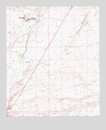
Rattlesnake Springs, NM USGS Topographic Map
Click on map above to begin viewing in our Map Viewer.

This topographic map contains these locations and features:
Feature Name Type Latitude Longitude GNIS ID View Map
Ballard RanchLocaleN32.0937°W104.4899°900824View Map
Bottomless Lake SpringSpringN32.0612°W104.4699°902606View Map
Bottomless LakesLakeN32.0624°W104.4715°886658View Map
Butcher WellLocaleN32.0023°W104.4558°886980View Map
C P HillSummitN32.0707°W104.4181°887016View Map
Circle K Ranch (historical)LocaleN32.1164°W104.4559°900897View Map
Hoffman TankReservoirN32.0637°W104.4901°890046View Map
Mayes RanchLocaleN32.0554°W104.4969°900704View Map
Nuevo CanyonValleyN32.1202°W104.4887°909217View Map
Old C P RanchLocaleN32.0460°W104.4119°900896View Map
Old Wallace SmithMineN32.0368°W104.4505°917594View Map
Rattlesnake CanyonValleyN32.1202°W104.4486°910021View Map
Rattlesnake SpringsSpringN32.1093°W104.4716°893691View Map
Rattlesnake Springs Picnic AreaAreaN32.1112°W104.4655°893693View Map
Slaughter Canyon DrawValleyN32.0860°W104.4724°898438View Map
Whites City Volunteer Fire Department Station 2BuildingN32.1071°W104.4602°2657795View Map
Yeso HillsRangeN32.0151°W104.4526°896821View Map

Note: Coordinates in the location and feature list above are referenced to NAD83 datum.


Copyright (C) 2008-2025 Ryan Niemi / Sunset Dynamics ... All Rights Reserved