TopoQuest Logo
Do you find TopoQuest useful?
Help keep TopoQuest running and adding new maps/features by donating!
Bitcoin:  19c7KJd3qBynnjoSw5npx9KScwjBe4ifkT
Litecoin:  LXs6TkuXGGXo1vDsWCkWVdjQX94eUKd6ui
Home View Maps Find Maps Find Places Resources & Links


Ravenden, Arkansas Topographic Map

USGS Map Title: Ravenden, AR
USGS Map MRC: 36091B3
DRG (GeoTIFF) Download: o36091b3.tif


Neighboring USGS Topographic Map Quads:


  Hardy, AR  
36091C4
 

  Williford, AR  
36091C3
 

  Ravenden Springs, AR  
36091C2
 

  Sitka, AR  
36091B4
 

  Ravenden, AR  
36091B3
 

  Imboden, AR  
36091B2
 

  Poughkeepsie, AR  
36091A4
 

  Smithville, AR  
36091A3
 

  Eaton, AR  
36091A2


Map MRC Location:

N37°
W92°
N37°
W91°
H8 H7 H6 H5 H4 H3 H2 H1
G8 G7 G6 G5 G4 G3 G2 G1
F8 F7 F6 F5 F4 F3 F2 F1
E8 E7 E6 E5 E4 E3 E2 E1
D8 D7 D6 D5 D4 D3 D2 D1
C8 C7 C6 C5 C4 C3 C2 C1
B8 B7 B6 B5 B4 B3 B2 B1
A8 A7 A6 A5 A4 A3 A2 A1
N36°
W92°
N36°
W91°

Ravenden, AR USGS 1:24K Topographic Map Preview:
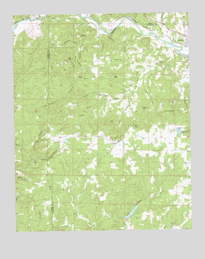
Ravenden, AR USGS Topographic Map
Click on map above to begin viewing in our Map Viewer.

This topographic map contains these locations and features:
Feature Name Type Latitude Longitude GNIS ID View Map
Amos HollowValleyN36.2367°W91.3140°45858View Map
Bald KnobSummitN36.2137°W91.3035°57314View Map
Ball HollowValleyN36.2451°W91.3729°46058View Map
Bates CreekStreamN36.2487°W91.3193°46149View Map
Big Lick HillSummitN36.1848°W91.2899°57374View Map
Browns CreekStreamN36.2320°W91.2610°47023View Map
Buzzard HollowValleyN36.2317°W91.3246°47248View Map
Buzzard Roost CanyonValleyN36.2028°W91.2557°47249View Map
Camp BranchStreamN36.2034°W91.3115°47308View Map
Captain Sanders HollowValleyN36.1651°W91.3604°47463View Map
Carl Phillips Lake DamDamN36.1817°W91.2568°79910View Map
Cave HillSummitN36.1876°W91.3071°57529View Map
Coffman CemeteryCemeteryN36.1278°W91.3423°47892View Map
Cooper Creek Site Two DamDamN36.1351°W91.2968°79889View Map
Cooper Creek Site Two ReservoirReservoirN36.1351°W91.2968°79890View Map
East Prong Wells CreekStreamN36.2037°W91.2912°48774View Map
Field MountainSummitN36.2242°W91.3362°57750View Map
Friendship ChurchChurchN36.1753°W91.3018°49269View Map
Frisbee (historical)Populated PlaceN36.1792°W91.3251°61554View Map
Gattis CreekStreamN36.2145°W91.2818°49360View Map
Goat Shed MountainSummitN36.2373°W91.3279°57826View Map
Graveyard RidgeRidgeN36.2165°W91.3460°49603View Map
Homestead HollowValleyN36.2312°W91.3271°50274View Map
Jeff CreekStreamN36.2390°W91.3071°50601View Map
Little Joe LakeReservoirN36.1816°W91.2588°79911View Map
Lone Oak ChurchChurchN36.1501°W91.3507°51399View Map
Mill HollowValleyN36.2478°W91.2915°52044View Map
Mount OliveSummitN36.2134°W91.3254°58306View Map
Oliver CreekStreamN36.2492°W91.3282°53044View Map
Opossum HollowValleyN36.2378°W91.3076°53061View Map
Opposition (historical)Populated PlaceN36.2287°W91.2960°61555View Map
Opposition CemeteryCemeteryN36.2220°W91.2712°53065View Map
Opposition CreekStreamN36.2187°W91.2732°53066View Map
Panther HillSummitN36.1953°W91.2835°58321View Map
Park CemeteryCemeteryN36.1256°W91.2626°53183View Map
RavendenPopulated PlaceN36.2334°W91.2518°58465View Map
Ravenden Police DepartmentBuildingN36.2368°W91.2563°2118575View Map
Ravenden Post OfficePost OfficeN36.2385°W91.2598°2781950View Map
Ravenden Volunteer Fire DepartmentBuildingN36.2339°W91.2520°2117016View Map
Town of RavendenCivilN36.2417°W91.2512°2407176View Map
Township of Spring RiverCivilN36.1935°W91.3033°66801View Map
Township of ThackerCivilN36.2410°W91.2558°66803View Map
Upton CreekStreamN36.2401°W91.3737°55862View Map
Van Wagoner RidgeRidgeN36.2017°W91.3401°55882View Map
Watts BluffCliffN36.2406°W91.3029°56115View Map
Wautauga SpringSpringN36.1934°W91.2618°56119View Map
Wells CreekStreamN36.2278°W91.2596°56150View Map
Wild Hog HollowValleyN36.1673°W91.3612°56354View Map
Williford Post OfficePost OfficeN36.2499°W91.3595°84695View Map
Young RidgeRidgeN36.2217°W91.3310°56614View Map

Note: Coordinates in the location and feature list above are referenced to NAD83 datum.


Copyright (C) 2008-2025 Ryan Niemi / Sunset Dynamics ... All Rights Reserved