TopoQuest Logo
Do you find TopoQuest useful?
Help keep TopoQuest running and adding new maps/features by donating!
Bitcoin:  19c7KJd3qBynnjoSw5npx9KScwjBe4ifkT
Litecoin:  LXs6TkuXGGXo1vDsWCkWVdjQX94eUKd6ui
Home View Maps Find Maps Find Places Resources & Links


Smithville, Arkansas Topographic Map

USGS Map Title: Smithville, AR
USGS Map MRC: 36091A3
DRG (GeoTIFF) Download: o36091a3.tif


Neighboring USGS Topographic Map Quads:


  Sitka, AR  
36091B4
 

  Ravenden, AR  
36091B3
 

  Imboden, AR  
36091B2
 

  Poughkeepsie, AR  
36091A4
 

  Smithville, AR  
36091A3
 

  Eaton, AR  
36091A2
 

  Grange, AR  
35091H4
 

  Strawberry, AR  
35091H3
 

  Strangers Home, AR  
35091H2


Map MRC Location:

N37°
W92°
N37°
W91°
H8 H7 H6 H5 H4 H3 H2 H1
G8 G7 G6 G5 G4 G3 G2 G1
F8 F7 F6 F5 F4 F3 F2 F1
E8 E7 E6 E5 E4 E3 E2 E1
D8 D7 D6 D5 D4 D3 D2 D1
C8 C7 C6 C5 C4 C3 C2 C1
B8 B7 B6 B5 B4 B3 B2 B1
A8 A7 A6 A5 A4 A3 A2 A1
N36°
W92°
N36°
W91°

Smithville, AR USGS 1:24K Topographic Map Preview:
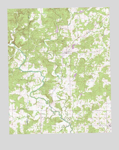
Smithville, AR USGS Topographic Map
Click on map above to begin viewing in our Map Viewer.

This topographic map contains these locations and features:
Feature Name Type Latitude Longitude GNIS ID View Map
Bratcher CemeteryCemeteryN36.0915°W91.3101°46920View Map
Clayton CreekStreamN36.0806°W91.3574°47820View Map
Cooper CreekStreamN36.0076°W91.2999°76668View Map
Cooper Creek Site Five DamDamN36.0551°W91.2901°79895View Map
Cooper Creek Site Five ReservoirReservoirN36.0551°W91.2901°79896View Map
Cooper Creek Site Four DamDamN36.0867°W91.3001°79893View Map
Cooper Creek Site Four ReservoirReservoirN36.0867°W91.3001°79894View Map
Cooper Creek Site One DamDamN36.1067°W91.3035°79887View Map
Cooper Creek Site One ReservoirReservoirN36.1067°W91.3035°79888View Map
Cooper Creek Site Six DamDamN36.0401°W91.2885°79897View Map
Cooper Creek Site Six ReservoirReservoirN36.0389°W91.2865°79898View Map
Cooper Creek Site Three DamDamN36.1234°W91.2918°79891View Map
Cooper Creek Site Three ReservoirReservoirN36.1234°W91.2918°79892View Map
Dogwood BranchStreamN36.1173°W91.2951°48556View Map
East Cooper CreekStreamN36.0953°W91.3143°48755View Map
Hillcrest Junior High SchoolSchoolN36.0103°W91.2529°2092997View Map
Hillhouse CemeteryCemeteryN36.0565°W91.3098°50126View Map
JesupPopulated PlaceN36.0170°W91.3362°57992View Map
Little CreekStreamN36.0417°W91.3093°51236View Map
LynnPopulated PlaceN36.0073°W91.2524°51525View Map
Lynn Elementary SchoolSchoolN36.0096°W91.2524°61561View Map
Lynn High SchoolSchoolN36.0103°W91.2529°61562View Map
Lynn Volunteer Fire DepartmentBuildingN36.0077°W91.2572°2116748View Map
Machine CreekStreamN36.0528°W91.3096°51586View Map
Mars BranchStreamN36.1006°W91.3682°51685View Map
Massey CemeteryCemeteryN36.0148°W91.3243°51736View Map
Mill CreekStreamN36.0153°W91.3687°52026View Map
Pine CreekStreamN36.0909°W91.3707°53415View Map
Reeds CreekStreamN36.0078°W91.3001°53973View Map
SmithvillePopulated PlaceN36.0803°W91.3037°58647View Map
Smithville Volunteer Fire DepartmentBuildingN36.0800°W91.3059°2117131View Map
South Big CreekStreamN36.0209°W91.3210°45762View Map
Town of LynnCivilN36.0044°W91.2517°2406066View Map
Town of SmithvilleCivilN36.0804°W91.3026°2407353View Map
Townsend CemeteryCemeteryN36.0912°W91.3329°55624View Map
Township of JesupCivilN36.0277°W91.3214°66794View Map
Township of StrawberryCivilN36.0946°W91.3004°66802View Map
Union Missionary ChurchChurchN36.0248°W91.3568°55827View Map
West Cooper CreekStreamN36.0953°W91.3143°56173View Map

Note: Coordinates in the location and feature list above are referenced to NAD83 datum.


Copyright (C) 2008-2024 Ryan Niemi / Sunset Dynamics ... All Rights Reserved