TopoQuest Logo
Do you find TopoQuest useful?
Help keep TopoQuest running and adding new maps/features by donating!
Bitcoin:  19c7KJd3qBynnjoSw5npx9KScwjBe4ifkT
Litecoin:  LXs6TkuXGGXo1vDsWCkWVdjQX94eUKd6ui
Home View Maps Find Maps Find Places Resources & Links


Sitka, Arkansas Topographic Map

USGS Map Title: Sitka, AR
USGS Map MRC: 36091B4
DRG (GeoTIFF) Download: o36091b4.tif


Neighboring USGS Topographic Map Quads:


  Stuart, AR  
36091C5
 

  Hardy, AR  
36091C4
 

  Williford, AR  
36091C3
 

  Ash Flat, AR  
36091B5
 

  Sitka, AR  
36091B4
 

  Ravenden, AR  
36091B3
 

  Evening Shade, AR  
36091A5
 

  Poughkeepsie, AR  
36091A4
 

  Smithville, AR  
36091A3


Map MRC Location:

N37°
W92°
N37°
W91°
H8 H7 H6 H5 H4 H3 H2 H1
G8 G7 G6 G5 G4 G3 G2 G1
F8 F7 F6 F5 F4 F3 F2 F1
E8 E7 E6 E5 E4 E3 E2 E1
D8 D7 D6 D5 D4 D3 D2 D1
C8 C7 C6 C5 C4 C3 C2 C1
B8 B7 B6 B5 B4 B3 B2 B1
A8 A7 A6 A5 A4 A3 A2 A1
N36°
W92°
N36°
W91°

Sitka, AR USGS 1:24K Topographic Map Preview:
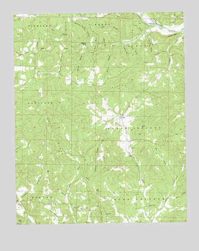
Sitka, AR USGS Topographic Map
Click on map above to begin viewing in our Map Viewer.

This topographic map contains these locations and features:
Feature Name Type Latitude Longitude GNIS ID View Map
Bettis ChurchChurchN36.1340°W91.4515°46489View Map
Bubbling SpringSpringN36.2323°W91.4468°47109View Map
Bubbling Spring HollowValleyN36.2281°W91.4440°47110View Map
Buchannan CemeteryCemeteryN36.1303°W91.4349°47114View Map
Buck RidgeRidgeN36.1792°W91.4735°47137View Map
Burrow HollowValleyN36.2270°W91.4410°47218View Map
Cat BranchStreamN36.1406°W91.4618°47520View Map
Dark HollowValleyN36.1392°W91.3882°48361View Map
Denim HillSummitN36.1820°W91.4076°57640View Map
Divide HillSummitN36.2034°W91.4118°57659View Map
Gann HillSummitN36.1776°W91.4096°57792View Map
Goff HollowValleyN36.2292°W91.4582°49471View Map
Hickory RidgeRidgeN36.1576°W91.4279°50075View Map
Hinkle HollowValleyN36.2370°W91.4049°50146View Map
Hopewell CemeteryCemeteryN36.1692°W91.4162°50306View Map
Howard BranchStreamN36.2290°W91.4279°50359View Map
Hurricane BluffCliffN36.2365°W91.3829°50428View Map
Kitchen HollowValleyN36.1359°W91.4946°50889View Map
Lawrence HollowValleyN36.2373°W91.4612°51006View Map
Long BranchStreamN36.2326°W91.4174°51412View Map
Low GapGapN36.1565°W91.4771°51492View Map
Markum HollowValleyN36.2312°W91.4193°51678View Map
Muncie HollowValleyN36.2298°W91.4321°52546View Map
Norton HollowValleyN36.2281°W91.4446°52847View Map
Osburn CreekStreamN36.1262°W91.4010°77930View Map
Phillips HollowValleyN36.2376°W91.4029°53340View Map
Pleasant Ridge ChurchChurchN36.1348°W91.4026°53598View Map
Rock CreekStreamN36.2420°W91.3951°54095View Map
Saffell HollowValleyN36.2326°W91.4146°54303View Map
Schales CemeteryCemeteryN36.1742°W91.4374°54617View Map
Sharp CountyCivilN36.1612°W91.4799°69183View Map
SitkaPopulated PlaceN36.1884°W91.4215°58630View Map
Spring HollowValleyN36.1548°W91.3790°55116View Map
Spurlock HollowValleyN36.2290°W91.4624°55139View Map
Swafford HollowValleyN36.2290°W91.4799°55363View Map
Tater HillSummitN36.1448°W91.4393°58735View Map
Timbered HollowValleyN36.1492°W91.4449°55579View Map
Township of DavidsonCivilN36.1966°W91.4978°69137View Map
Township of JacksonCivilN36.2379°W91.3973°69141View Map
Township of Lebanon (historical)CivilN36.1584°W91.4001°70213View Map
Township of North LebanonCivilN36.1808°W91.4051°69147View Map
Township of South LebanonCivilN36.1273°W91.3969°69154View Map
Tyner HillSummitN36.1692°W91.4051°58777View Map
Vaughn HollowValleyN36.2276°W91.4871°55894View Map
West Prong Osburn CreekStreamN36.1495°W91.3837°56198View Map

Note: Coordinates in the location and feature list above are referenced to NAD83 datum.


Copyright (C) 2008-2025 Ryan Niemi / Sunset Dynamics ... All Rights Reserved