TopoQuest Logo
Do you find TopoQuest useful?
Help keep TopoQuest running and adding new maps/features by donating!
Bitcoin:  19c7KJd3qBynnjoSw5npx9KScwjBe4ifkT
Litecoin:  LXs6TkuXGGXo1vDsWCkWVdjQX94eUKd6ui
Home View Maps Find Maps Find Places Resources & Links


Reagan, Oklahoma Topographic Map

USGS Map Title: Reagan, OK
USGS Map MRC: 34096C6
DRG (GeoTIFF) Download: o34096c6.tif


Neighboring USGS Topographic Map Quads:


  Mill Creek, OK  
34096D7
 

  Connerville, OK  
34096D6
 

  Connerville NE, OK  
34096D5
 

  Troy, OK  
34096C7
 

  Reagan, OK  
34096C6
 

  Connerville SE, OK  
34096C5
 

  Ravia, OK  
34096B7
 

  Tishomingo, OK  
34096B6
 

  Milburn, OK  
34096B5


Map MRC Location:

N35°
W97°
N35°
W96°
H8 H7 H6 H5 H4 H3 H2 H1
G8 G7 G6 G5 G4 G3 G2 G1
F8 F7 F6 F5 F4 F3 F2 F1
E8 E7 E6 E5 E4 E3 E2 E1
D8 D7 D6 D5 D4 D3 D2 D1
C8 C7 C6 C5 C4 C3 C2 C1
B8 B7 B6 B5 B4 B3 B2 B1
A8 A7 A6 A5 A4 A3 A2 A1
N34°
W97°
N34°
W96°

Reagan, OK USGS 1:24K Topographic Map Preview:
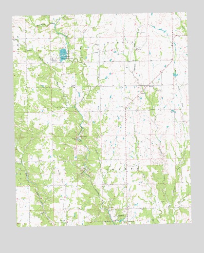
Reagan, OK USGS Topographic Map
Click on map above to begin viewing in our Map Viewer.

This topographic map contains these locations and features:
Feature Name Type Latitude Longitude GNIS ID View Map
Anvil Rock CemeteryCemeteryN34.3228°W96.7326°2709404View Map
Bullet PrairieFlatN34.2795°W96.7181°1090689View Map
Bullet Prairie CemeteryCemeteryN34.2660°W96.7147°1090690View Map
Buzzard CreekStreamN34.2618°W96.6397°1090762View Map
Devils DenGapN34.2815°W96.7014°1092059View Map
Duncan CemeteryCemeteryN34.2633°W96.6470°1092292View Map
Greenwood CemeteryCemeteryN34.3606°W96.7483°1093399View Map
Johnston CountyCivilN34.3165°W96.6607°1101822View Map
Keel CreekStreamN34.3468°W96.7003°1094304View Map
Oknoname 069001 DamDamN34.2901°W96.6986°1756090View Map
Oknoname 069001 ReservoirReservoirN34.2901°W96.6986°1756091View Map
Oknoname 069003 DamDamN34.2801°W96.6286°1756094View Map
Oknoname 069003 ReservoirReservoirN34.2801°W96.6286°1756095View Map
Pennington ChurchChurchN34.3543°W96.7406°1096541View Map
ReaganPopulated PlaceN34.3490°W96.7217°1097071View Map
Reagan BranchStreamN34.3201°W96.7069°1097072View Map
Reagan Volunteer Fire DepartmentBuildingN34.3502°W96.7228°2657376View Map
Slippery FallsFallsN34.3029°W96.7044°1098123View Map
Spring CreekStreamN34.3687°W96.7192°1098415View Map
Spring Creek Ranch AirportAirportN34.3566°W96.7360°2770430View Map
Three SpringsSpringN34.3632°W96.6610°1098876View Map
Tishomingo DivisionCivilN34.3630°W96.6691°1937888View Map
Tishomingo National Fish HatcheryLocaleN34.3504°W96.7142°1098927View Map
Township of GarrettCivilN34.2584°W96.6308°1824983View Map
Webb LakeReservoirN34.2518°W96.6786°1751747View Map
Webb Lake DamDamN34.2518°W96.6786°1751746View Map
Wolf SpringSpringN34.3545°W96.6630°1099974View Map

Note: Coordinates in the location and feature list above are referenced to NAD83 datum.


Copyright (C) 2008-2024 Ryan Niemi / Sunset Dynamics ... All Rights Reserved