TopoQuest Logo
Do you find TopoQuest useful?
Help keep TopoQuest running and adding new maps/features by donating!
Bitcoin:  19c7KJd3qBynnjoSw5npx9KScwjBe4ifkT
Litecoin:  LXs6TkuXGGXo1vDsWCkWVdjQX94eUKd6ui
Home View Maps Find Maps Find Places Resources & Links


Reagan Wells, Texas Topographic Map

USGS Map Title: Reagan Wells, TX
USGS Map MRC: 29099E7
DRG (GeoTIFF) Download: o29099e7.tif


Neighboring USGS Topographic Map Quads:


  Crown Mountain, TX  
29099F8
 

  Leakey, TX  
29099F7
 

  Rio Frio, TX  
29099F6
 

  Lake Creek, TX  
29099E8
 

  Reagan Wells, TX  
29099E7
 

  Magers Crossing, TX  
29099E6
 

  Sycamore Mountain, TX  
29099D8
 

  Deep Creek, TX  
29099D7
 

  Concan, TX  
29099D6


Map MRC Location:

N30°
W100°
N30°
W99°
H8 H7 H6 H5 H4 H3 H2 H1
G8 G7 G6 G5 G4 G3 G2 G1
F8 F7 F6 F5 F4 F3 F2 F1
E8 E7 E6 E5 E4 E3 E2 E1
D8 D7 D6 D5 D4 D3 D2 D1
C8 C7 C6 C5 C4 C3 C2 C1
B8 B7 B6 B5 B4 B3 B2 B1
A8 A7 A6 A5 A4 A3 A2 A1
N29°
W100°
N29°
W99°

Reagan Wells, TX USGS 1:24K Topographic Map Preview:
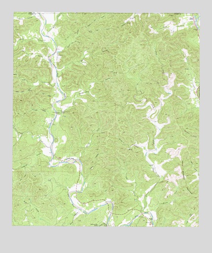
Reagan Wells, TX USGS Topographic Map
Click on map above to begin viewing in our Map Viewer.

This topographic map contains these locations and features:
Feature Name Type Latitude Longitude GNIS ID View Map
Bailey HollowValleyN29.5438°W99.7854°1329927View Map
Brushy CreekStreamN29.5388°W99.8328°1331418View Map
Buck HollowValleyN29.5102°W99.8303°1372790View Map
Burn HollowValleyN29.5873°W99.8458°1331690View Map
Calf HollowValleyN29.5750°W99.8480°1331880View Map
Cedar Lick HollowValleyN29.5819°W99.8602°1332461View Map
Cherry HollowValleyN29.5277°W99.8267°1332713View Map
Cox HollowValleyN29.5958°W99.8505°1333581View Map
Cummins - Heard CemeteryCemeteryN29.5663°W99.8434°1333812View Map
Devils Backbone MountainSummitN29.5300°W99.7592°1334291View Map
Flying J Ranch AirportAirportN29.5974°W99.8468°1387064View Map
Fulghum HollowValleyN29.5378°W99.8504°1336289View Map
Fush CreekStreamN29.5083°W99.7870°1336313View Map
Gaines HollowValleyN29.6230°W99.8577°1336339View Map
Happy HollowPopulated PlaceN29.6219°W99.7537°1337320View Map
Heard Community CenterLocaleN29.5666°W99.8426°1337535View Map
Honey CreekStreamN29.5458°W99.8501°1338015View Map
Lick CreekStreamN29.5819°W99.8453°1339899View Map
Lightning Bug HollowValleyN29.5012°W99.8117°1374530View Map
Lightning Bug SpringSpringN29.5009°W99.8180°1339916View Map
Little York HollowValleyN29.6068°W99.8374°1340223View Map
Long HollowValleyN29.5646°W99.8468°1340460View Map
Mare CreekStreamN29.6113°W99.8526°1340940View Map
Mine HollowValleyN29.5670°W99.8458°1341706View Map
Mouser CreekStreamN29.5083°W99.7828°1342176View Map
North York HollowValleyN29.6172°W99.8255°1342852View Map
Pecan CreekStreamN29.6199°W99.7531°1343759View Map
Pine HollowValleyN29.5097°W99.7875°1344057View Map
Reagan WellsPopulated PlaceN29.5388°W99.8370°1344871View Map
South York HollowValleyN29.6169°W99.8255°1347576View Map
Water HollowValleyN29.6064°W99.8533°1349537View Map
West Prong Flush CreekStreamN29.5580°W99.7778°1349787View Map
York HollowValleyN29.6039°W99.8464°2785045View Map

Note: Coordinates in the location and feature list above are referenced to NAD83 datum.


Copyright (C) 2008-2024 Ryan Niemi / Sunset Dynamics ... All Rights Reserved