TopoQuest Logo
Do you find TopoQuest useful?
Help keep TopoQuest running and adding new maps/features by donating!
Bitcoin:  19c7KJd3qBynnjoSw5npx9KScwjBe4ifkT
Litecoin:  LXs6TkuXGGXo1vDsWCkWVdjQX94eUKd6ui
Home View Maps Find Maps Find Places Resources & Links


Rio Frio, Texas Topographic Map

USGS Map Title: Rio Frio, TX
USGS Map MRC: 29099F6
DRG (GeoTIFF) Download: o29099f6.tif


Neighboring USGS Topographic Map Quads:


  Owl Hollow, TX  
29099G7
 

  Circle Bluff, TX  
29099G6
 

  Sabinal Canyon, TX  
29099G5
 

  Leakey, TX  
29099F7
 

  Rio Frio, TX  
29099F6
 

  Vanderpool, TX  
29099F5
 

  Reagan Wells, TX  
29099E7
 

  Magers Crossing, TX  
29099E6
 

  Utopia, TX  
29099E5


Map MRC Location:

N30°
W100°
N30°
W99°
H8 H7 H6 H5 H4 H3 H2 H1
G8 G7 G6 G5 G4 G3 G2 G1
F8 F7 F6 F5 F4 F3 F2 F1
E8 E7 E6 E5 E4 E3 E2 E1
D8 D7 D6 D5 D4 D3 D2 D1
C8 C7 C6 C5 C4 C3 C2 C1
B8 B7 B6 B5 B4 B3 B2 B1
A8 A7 A6 A5 A4 A3 A2 A1
N29°
W100°
N29°
W99°

Rio Frio, TX USGS 1:24K Topographic Map Preview:
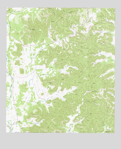
Rio Frio, TX USGS Topographic Map
Click on map above to begin viewing in our Map Viewer.

This topographic map contains these locations and features:
Feature Name Type Latitude Longitude GNIS ID View Map
Bailey HollowValleyN29.6266°W99.6774°1329928View Map
Beard HollowValleyN29.6565°W99.6618°1330256View Map
Casey Three Ranch Airport (historical)AirportN29.6333°W99.7289°1387397View Map
Deep CreekStreamN29.6822°W99.7195°1334188View Map
Deer CreekStreamN29.6552°W99.7256°1334207View Map
Dry BranchStreamN29.6836°W99.7048°1334639View Map
East Frio RiverStreamN29.7408°W99.7498°1373548View Map
Flat CreekStreamN29.6819°W99.7456°1335895View Map
Franklin HollowValleyN29.6288°W99.6354°1336155View Map
Friday HollowValleyN29.6563°W99.7071°1336213View Map
Harrison LakeReservoirN29.6736°W99.7237°1862087View Map
Harrison Lake DamDamN29.6736°W99.7237°1862086View Map
Little Dry Frio CreekStreamN29.6324°W99.7462°1374577View Map
Long HollowValleyN29.7133°W99.7020°1340463View Map
Massey HollowValleyN29.7214°W99.6255°1341058View Map
Meridian MountainSummitN29.7280°W99.7209°1341381View Map
Moore HollowValleyN29.6627°W99.6903°1341868View Map
Morris HollowValleyN29.6341°W99.6723°1341939View Map
Mud SpringSpringN29.6758°W99.6678°1342212View Map
Panther SpringsSpringN29.6666°W99.6512°1343559View Map
Pole HollowValleyN29.6349°W99.7308°1344309View Map
Ringhorn HollowValleyN29.6689°W99.7067°1345239View Map
Rio FrioPopulated PlaceN29.6361°W99.7367°1345243View Map
Rio Frio Post OfficePost OfficeN29.6414°W99.7369°2731184View Map
West Frio RiverStreamN29.7411°W99.7498°1376707View Map

Note: Coordinates in the location and feature list above are referenced to NAD83 datum.


Copyright (C) 2008-2025 Ryan Niemi / Sunset Dynamics ... All Rights Reserved