TopoQuest Logo
Do you find TopoQuest useful?
Help keep TopoQuest running and adding new maps/features by donating!
Bitcoin:  19c7KJd3qBynnjoSw5npx9KScwjBe4ifkT
Litecoin:  LXs6TkuXGGXo1vDsWCkWVdjQX94eUKd6ui
Home View Maps Find Maps Find Places Resources & Links


Redbank, Texas Topographic Map

USGS Map Title: Redbank, TX
USGS Map MRC: 33094E3
DRG (GeoTIFF) Download: o33094e3.tif


Neighboring USGS Topographic Map Quads:


  Foreman, AR  
33094F4
 

  Arden, AR  
33094F3
 

  Ashdown West, AR  
33094F2
 

  Daniels Chapel, TX  
33094E4
 

  Redbank, TX  
33094E3
 

  Barkman, TX  
33094E2
 

  New Boston, TX  
33094D4
 

  Hooks, TX  
33094D3
 

  Leary, TX  
33094D2


Map MRC Location:

N34°
W95°
N34°
W94°
H8 H7 H6 H5 H4 H3 H2 H1
G8 G7 G6 G5 G4 G3 G2 G1
F8 F7 F6 F5 F4 F3 F2 F1
E8 E7 E6 E5 E4 E3 E2 E1
D8 D7 D6 D5 D4 D3 D2 D1
C8 C7 C6 C5 C4 C3 C2 C1
B8 B7 B6 B5 B4 B3 B2 B1
A8 A7 A6 A5 A4 A3 A2 A1
N33°
W95°
N33°
W94°

Redbank, TX USGS 1:24K Topographic Map Preview:
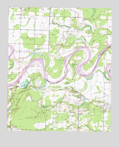
Redbank, TX USGS Topographic Map
Click on map above to begin viewing in our Map Viewer.

This topographic map contains these locations and features:
Feature Name Type Latitude Longitude GNIS ID View Map
Applewhite Cut-off LakeLakeN33.5442°W94.3546°75630View Map
Black BottomValleyN33.5309°W94.2763°1352283View Map
BurnsPopulated PlaceN33.5182°W94.2891°1353352View Map
Cattail LakeSwampN33.6232°W94.2713°47532View Map
Cedar Springs ChurchChurchN33.5193°W94.2994°1354151View Map
Cranfell LakeReservoirN33.5357°W94.2869°1355313View Map
Cranfill Airfield (historical)AirportN33.5311°W94.2908°2120335View Map
Crooked SloughStreamN33.5973°W94.2963°48182View Map
Dunn LakeLakeN33.6069°W94.2805°48716View Map
Ector LakeLakeN33.5676°W94.2963°1356808View Map
Elizabeth Baptist ChurchChurchN33.5876°W94.3094°76866View Map
Friendship ChurchChurchN33.6173°W94.3605°49258View Map
Friendship School (historical)SchoolN33.6176°W94.3608°60110View Map
Hubbard SloughLakeN33.5422°W94.3076°1359759View Map
Hudson BowBendN33.5621°W94.3430°1359776View Map
Hudson LakeLakeN33.5626°W94.3732°75745View Map
Hughes CemeteryCemeteryN33.5043°W94.3749°1359799View Map
Jack CreekStreamN33.5262°W94.3160°1360081View Map
LaVoice LakeLakeN33.5788°W94.3367°75752View Map
Little Red LakeLakeN33.5485°W94.3026°1361438View Map
Panther CreekStreamN33.5037°W94.3194°1364781View Map
Red BayouStreamN33.5532°W94.3310°1366109View Map
Red Oak Baptist ChurchChurchN33.6043°W94.2905°78148View Map
Red Oak Grove CemeteryCemeteryN33.6034°W94.2896°60163View Map
RedbankPopulated PlaceN33.5260°W94.2588°1366267View Map
Smith Club DamDamN33.5335°W94.2819°1854957View Map
Smith Club LakeReservoirN33.5347°W94.2843°1368477View Map
Smith HillPopulated PlaceN33.5401°W94.2949°1368487View Map
Smith LakeLakeN33.5538°W94.2755°1368492View Map
Walnut Grove ChurchChurchN33.6137°W94.2833°56003View Map
Whaley LakeLakeN33.5438°W94.3347°1371314View Map
Wilson LakeLakeN33.5546°W94.2563°1371722View Map

Note: Coordinates in the location and feature list above are referenced to NAD83 datum.


Copyright (C) 2008-2025 Ryan Niemi / Sunset Dynamics ... All Rights Reserved