TopoQuest Logo
Do you find TopoQuest useful?
Help keep TopoQuest running and adding new maps/features by donating!
Bitcoin:  19c7KJd3qBynnjoSw5npx9KScwjBe4ifkT
Litecoin:  LXs6TkuXGGXo1vDsWCkWVdjQX94eUKd6ui
Home View Maps Find Maps Find Places Resources & Links


Foreman, Arkansas Topographic Map

USGS Map Title: Foreman, AR
USGS Map MRC: 33094F4
DRG (GeoTIFF) Download: o33094f4.tif


Neighboring USGS Topographic Map Quads:


  Bokhoma, OK  
33094G5
 

  Arkinda, AR  
33094G4
 

  Winthrop, AR  
33094G3
 

  Tom, OK  
33094F5
 

  Foreman, AR  
33094F4
 

  Arden, AR  
33094F3
 

  De Kalb, TX  
33094E5
 

  Daniels Chapel, TX  
33094E4
 

  Redbank, TX  
33094E3


Map MRC Location:

N34°
W95°
N34°
W94°
H8 H7 H6 H5 H4 H3 H2 H1
G8 G7 G6 G5 G4 G3 G2 G1
F8 F7 F6 F5 F4 F3 F2 F1
E8 E7 E6 E5 E4 E3 E2 E1
D8 D7 D6 D5 D4 D3 D2 D1
C8 C7 C6 C5 C4 C3 C2 C1
B8 B7 B6 B5 B4 B3 B2 B1
A8 A7 A6 A5 A4 A3 A2 A1
N33°
W95°
N33°
W94°

Foreman, AR USGS 1:24K Topographic Map Preview:
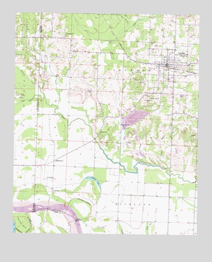
Foreman, AR USGS Topographic Map
Click on map above to begin viewing in our Map Viewer.

This topographic map contains these locations and features:
Feature Name Type Latitude Longitude GNIS ID View Map
Black BranchStreamN33.6962°W94.4702°70691View Map
Blackland CemeteryCemeteryN33.7387°W94.4671°60087View Map
Blackland ChurchChurchN33.7390°W94.4652°70705View Map
Blackland School (historical)SchoolN33.7387°W94.4660°60088View Map
Bright Star Baptist ChurchChurchN33.6871°W94.4277°76416View Map
Catholic CemeteryCemeteryN33.7018°W94.4080°60092View Map
City of ForemanCivilN33.7198°W94.3979°2403631View Map
Dollarhide CemeteryCemeteryN33.7112°W94.4113°71406View Map
Dunbar LakeReservoirN33.6751°W94.3869°80913View Map
Dunbar Lake DamDamN33.6751°W94.3869°80912View Map
ForemanPopulated PlaceN33.7218°W94.3969°71657View Map
Foreman Elementary SchoolSchoolN33.7162°W94.4005°2039337View Map
Foreman High SchoolSchoolN33.7128°W94.3935°60108View Map
Foreman Marshall's OfficeBuildingN33.7203°W94.3967°2118953View Map
Foreman Volunteer Fire DepartmentBuildingN33.7201°W94.3954°2116437View Map
Foremen Elementary SchoolSchoolN33.7135°W94.3958°60107View Map
French BranchStreamN33.6654°W94.4277°71687View Map
French CemeteryCemeteryN33.6771°W94.4199°71688View Map
French CemeteryCemeteryN33.7340°W94.4085°71689View Map
French ChurchChurchN33.6829°W94.4410°71690View Map
French CreekStreamN33.6698°W94.4274°71691View Map
Hamilton LakeLakeN33.6568°W94.4463°74877View Map
Haw BranchStreamN33.7432°W94.4205°71942View Map
Hawkins CemeteryCemeteryN33.7021°W94.4166°77150View Map
Holy Cross ChurchChurchN33.7023°W94.4077°72051View Map
Hopson CemeteryCemeteryN33.7059°W94.4496°72070View Map
John Tom IslandIslandN33.6307°W94.4935°1101486View Map
LanesportPopulated PlaceN33.6493°W94.4730°77444View Map
Lime Rock HillSummitN33.7007°W94.4069°72354View Map
Line CreekStreamN33.7140°W94.4722°72357View Map
M C Jones Lake Number OneReservoirN33.6735°W94.4135°80911View Map
M C Jones Lake Number One DamDamN33.6735°W94.4135°80910View Map
M C Jones Lake Number Two DamDamN33.6751°W94.4135°81089View Map
Matteson GinLocaleN33.6665°W94.4716°72569View Map
McKinney CreekStreamN33.7017°W94.4794°72607View Map
Old River LakeLakeN33.6432°W94.4502°60151View Map
Oscar Hamilton Elementary SchoolSchoolN33.7161°W94.4004°2093005View Map
Oscar Hamilton Elementary SchoolSchoolN33.7303°W94.4062°2121481View Map
Pyron LakeReservoirN33.7321°W94.4052°80907View Map
Pyron Lake DamDamN33.7318°W94.4052°80906View Map
Rocky ComfortPopulated PlaceN33.7051°W94.4058°60170View Map
Saint Paul ChurchChurchN33.6565°W94.4735°73458View Map
Sand Hill CemeteryCemeteryN33.7257°W94.4986°1101647View Map
Sterling BranchStreamN33.6590°W94.3944°73697View Map
Township of JacksonCivilN33.7161°W94.4154°66836View Map
Turner ChurchChurchN33.6929°W94.3924°78599View Map
Two ReservoirReservoirN33.6751°W94.4135°81090View Map
Vinegar HillSummitN33.7034°W94.4944°1101715View Map

Note: Coordinates in the location and feature list above are referenced to NAD83 datum.


Copyright (C) 2008-2025 Ryan Niemi / Sunset Dynamics ... All Rights Reserved