TopoQuest Logo
Do you find TopoQuest useful?
Help keep TopoQuest running and adding new maps/features by donating!
Bitcoin:  19c7KJd3qBynnjoSw5npx9KScwjBe4ifkT
Litecoin:  LXs6TkuXGGXo1vDsWCkWVdjQX94eUKd6ui
Home View Maps Find Maps Find Places Resources & Links


Reedyville, Kentucky Topographic Map

USGS Map Title: Reedyville, KY
USGS Map MRC: 37086B4
DRG (GeoTIFF) Download: o37086b4.tif


Neighboring USGS Topographic Map Quads:


  Welchs Creek, KY  
37086C5
 

  Ready, KY  
37086C4
 

  Bee Spring, KY  
37086C3
 

  Riverside, KY  
37086B5
 

  Reedyville, KY  
37086B4
 

  Brownsville, KY  
37086B3
 

  Hadley, KY  
37086A5
 

  Bowling Green North, KY  
37086A4
 

  Bristow, KY  
37086A3


Map MRC Location:

N38°
W87°
N38°
W86°
H8 H7 H6 H5 H4 H3 H2 H1
G8 G7 G6 G5 G4 G3 G2 G1
F8 F7 F6 F5 F4 F3 F2 F1
E8 E7 E6 E5 E4 E3 E2 E1
D8 D7 D6 D5 D4 D3 D2 D1
C8 C7 C6 C5 C4 C3 C2 C1
B8 B7 B6 B5 B4 B3 B2 B1
A8 A7 A6 A5 A4 A3 A2 A1
N37°
W87°
N37°
W86°

Reedyville, KY USGS 1:24K Topographic Map Preview:
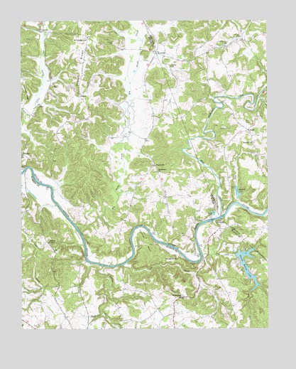
Reedyville, KY USGS Topographic Map
Click on map above to begin viewing in our Map Viewer.

This topographic map contains these locations and features:
Feature Name Type Latitude Longitude GNIS ID View Map
Bear CreekStreamN37.1703°W86.3991°486554View Map
Bethlehem Church of ChristChurchN37.1884°W86.4300°487020View Map
Big Reedy CreekStreamN37.1673°W86.4730°487231View Map
Caney HollowValleyN37.2187°W86.3790°488874View Map
Cardwell CemeteryCemeteryN37.2231°W86.4839°488932View Map
Cherrys ChapelChurchN37.1600°W86.4861°489417View Map
Clay LickStreamN37.1548°W86.4083°489576View Map
Cub Creek CemeteryCemeteryN37.2439°W86.3880°490443View Map
Cub Creek ChurchChurchN37.2403°W86.3953°490444View Map
Fallover BendBendN37.1603°W86.4375°491962View Map
GlenmorePopulated PlaceN37.1684°W86.3989°508099View Map
Gravel CemeteryCemeteryN37.1825°W86.3939°493175View Map
Greenfield BranchStreamN37.2492°W86.4880°493326View Map
Honakers CemeteryCemeteryN37.1561°W86.4122°494470View Map
Honakers FerryLocaleN37.1550°W86.4097°494471View Map
Hunts ChurchChurchN37.2317°W86.4236°494794View Map
Indian CreekStreamN37.1506°W86.4592°494928View Map
Ivy CreekStreamN37.1509°W86.4486°495064View Map
Lick BranchStreamN37.1759°W86.3897°496404View Map
Massey SpringSpringN37.1534°W86.4214°497672View Map
Mount Lebanon SchoolSchoolN37.2425°W86.4661°498767View Map
Mount Pleasant ChurchChurchN37.1369°W86.4197°498839View Map
Naker (historical)Populated PlaceN37.1690°W86.4088°2742344View Map
Raymer LakeLakeN37.1798°W86.3903°501623View Map
Red Hill ChurchChurchN37.2003°W86.3822°501657View Map
ReedyvillePopulated PlaceN37.1914°W86.4316°508917View Map
RegionLocaleN37.2203°W86.4703°501714View Map
Region RidgeRidgeN37.2300°W86.4703°501715View Map
Rosy CreekStreamN37.2123°W86.4975°502371View Map
Round HillSummitN37.2366°W86.4362°2742350View Map
RoundhillPopulated PlaceN37.2370°W86.4308°508979View Map
SegalPopulated PlaceN37.2056°W86.3850°509027View Map
Shanty Hollow LakeReservoirN37.1531°W86.3885°503250View Map
Threlkel CemeteryCemeteryN37.2409°W86.4522°505256View Map
VineyardPopulated PlaceN37.2459°W86.4883°509291View Map

Note: Coordinates in the location and feature list above are referenced to NAD83 datum.


Copyright (C) 2008-2025 Ryan Niemi / Sunset Dynamics ... All Rights Reserved