TopoQuest Logo
Do you find TopoQuest useful?
Help keep TopoQuest running and adding new maps/features by donating!
Bitcoin:  19c7KJd3qBynnjoSw5npx9KScwjBe4ifkT
Litecoin:  LXs6TkuXGGXo1vDsWCkWVdjQX94eUKd6ui
Home View Maps Find Maps Find Places Resources & Links


Ready, Kentucky Topographic Map

USGS Map Title: Ready, KY
USGS Map MRC: 37086C4
DRG (GeoTIFF) Download: o37086c4.tif


Neighboring USGS Topographic Map Quads:


  Spring Lick, KY  
37086D5
 

  Caneyville, KY  
37086D4
 

  Leitchfield, KY  
37086D3
 

  Welchs Creek, KY  
37086C5
 

  Ready, KY  
37086C4
 

  Bee Spring, KY  
37086C3
 

  Riverside, KY  
37086B5
 

  Reedyville, KY  
37086B4
 

  Brownsville, KY  
37086B3


Map MRC Location:

N38°
W87°
N38°
W86°
H8 H7 H6 H5 H4 H3 H2 H1
G8 G7 G6 G5 G4 G3 G2 G1
F8 F7 F6 F5 F4 F3 F2 F1
E8 E7 E6 E5 E4 E3 E2 E1
D8 D7 D6 D5 D4 D3 D2 D1
C8 C7 C6 C5 C4 C3 C2 C1
B8 B7 B6 B5 B4 B3 B2 B1
A8 A7 A6 A5 A4 A3 A2 A1
N37°
W87°
N37°
W86°

Ready, KY USGS 1:24K Topographic Map Preview:
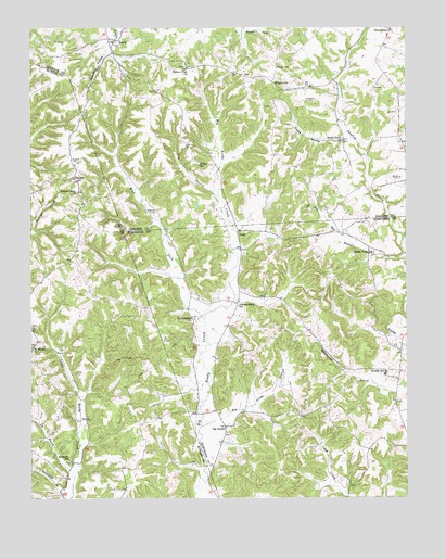
Ready, KY USGS Topographic Map
Click on map above to begin viewing in our Map Viewer.

This topographic map contains these locations and features:
Feature Name Type Latitude Longitude GNIS ID View Map
Beech Grove ChurchChurchN37.3453°W86.3961°486724View Map
Bethel CemeteryCemeteryN37.3353°W86.3766°486951View Map
Big ReedyPopulated PlaceN37.2692°W86.4355°507508View Map
Big Reedy BranchStreamN37.2692°W86.4433°487230View Map
DeckerPopulated PlaceN37.3353°W86.4855°507832View Map
Dry BranchStreamN37.3306°W86.4383°491144View Map
Hays SchoolSchoolN37.3648°W86.4180°493939View Map
Independence SchoolSchoolN37.3012°W86.4314°494907View Map
Joe BranchStreamN37.2556°W86.4858°495293View Map
LeePopulated PlaceN37.2959°W86.4994°508439View Map
Mount Pleasant ChurchChurchN37.2981°W86.4464°498843View Map
NashPopulated PlaceN37.3203°W86.4308°508672View Map
Preston CemeteryCemeteryN37.3562°W86.4080°501300View Map
Rabbit Flat ChurchChurchN37.3645°W86.4480°501490View Map
ReadyPopulated PlaceN37.3717°W86.4714°508908View Map
Renfrow SchoolSchoolN37.2600°W86.4872°501728View Map
Rowe HollowValleyN37.3456°W86.3958°502425View Map
Saint Marys ChurchChurchN37.2903°W86.4991°502691View Map
Slate Bank (historical)Populated PlaceN37.3185°W86.4531°2742742View Map
Sunfish DivisionCivilN37.2786°W86.3959°1937284View Map
Sunfish SchoolSchoolN37.2837°W86.3819°504793View Map
Sunny Point SchoolSchoolN37.3153°W86.3858°504796View Map
Welchs CreekStreamN37.3209°W86.4997°485708View Map
Welchs Creek ChurchChurchN37.3317°W86.4844°506363View Map
West Fork Big Reedy CreekStreamN37.2964°W86.4422°506422View Map
Willis SchoolSchoolN37.3389°W86.4441°506849View Map
WindyvillePopulated PlaceN37.3603°W86.4189°509384View Map
Woodbury HollowValleyN37.3687°W86.4725°507089View Map
Woosley CemeteryCemeteryN37.3267°W86.4583°507136View Map
Woosley CemeteryCemeteryN37.3398°W86.4839°507137View Map

Note: Coordinates in the location and feature list above are referenced to NAD83 datum.


Copyright (C) 2008-2024 Ryan Niemi / Sunset Dynamics ... All Rights Reserved