TopoQuest Logo
Do you find TopoQuest useful?
Help keep TopoQuest running and adding new maps/features by donating!
Bitcoin:  19c7KJd3qBynnjoSw5npx9KScwjBe4ifkT
Litecoin:  LXs6TkuXGGXo1vDsWCkWVdjQX94eUKd6ui
Home View Maps Find Maps Find Places Resources & Links


Brownsville, Kentucky Topographic Map

USGS Map Title: Brownsville, KY
USGS Map MRC: 37086B3
DRG (GeoTIFF) Download: o37086b3.tif


Neighboring USGS Topographic Map Quads:


  Ready, KY  
37086C4
 

  Bee Spring, KY  
37086C3
 

  Nolin Lake, KY  
37086C2
 

  Reedyville, KY  
37086B4
 

  Brownsville, KY  
37086B3
 

  Rhoda, KY  
37086B2
 

  Bowling Green North, KY  
37086A4
 

  Bristow, KY  
37086A3
 

  Smiths Grove, KY  
37086A2


Map MRC Location:

N38°
W87°
N38°
W86°
H8 H7 H6 H5 H4 H3 H2 H1
G8 G7 G6 G5 G4 G3 G2 G1
F8 F7 F6 F5 F4 F3 F2 F1
E8 E7 E6 E5 E4 E3 E2 E1
D8 D7 D6 D5 D4 D3 D2 D1
C8 C7 C6 C5 C4 C3 C2 C1
B8 B7 B6 B5 B4 B3 B2 B1
A8 A7 A6 A5 A4 A3 A2 A1
N37°
W87°
N37°
W86°

Brownsville, KY USGS 1:24K Topographic Map Preview:
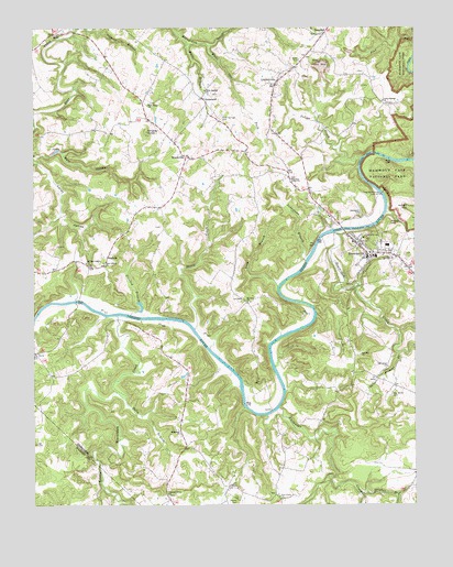
Brownsville, KY USGS Topographic Map
Click on map above to begin viewing in our Map Viewer.

This topographic map contains these locations and features:
Feature Name Type Latitude Longitude GNIS ID View Map
Alexander CemeteryCemeteryN37.2009°W86.2672°510237View Map
Alexander CreekStreamN37.1503°W86.2947°485827View Map
AsphaltPopulated PlaceN37.1909°W86.3500°507422View Map
Bear Creek Fire DepartmentBuildingN37.2464°W86.3708°2636981View Map
Beaverdam CreekStreamN37.1964°W86.2761°486628View Map
BrownsvillePopulated PlaceN37.1925°W86.2678°488045View Map
Brownsville Fire DepartmentBuildingN37.1909°W86.2633°2636418View Map
Brownsville North DivisionCivilN37.2466°W86.3079°1936892View Map
Camp JoyLocaleN37.1956°W86.2655°488701View Map
City of BrownsvilleCivilN37.1952°W86.2691°2403940View Map
Crooked BranchStreamN37.1750°W86.3430°490370View Map
Cub CreekStreamN37.2278°W86.3744°490442View Map
Edmonson County Ambulance ServiceBuildingN37.2135°W86.2865°2719103View Map
Edmonson County Sheriff's OfficeBuildingN37.1932°W86.2673°2767625View Map
GrasslandLocaleN37.2312°W86.3183°493138View Map
Green River Lock Number 6 (historical)DamN37.2064°W86.2608°517153View Map
Gulf HollowValleyN37.2173°W86.3653°493466View Map
Hawks CemeteryCemeteryN37.1267°W86.3086°493894View Map
Holly Springs CemeteryCemeteryN37.2275°W86.3122°494415View Map
Holly Springs ChurchChurchN37.2337°W86.3180°494416View Map
Honey CreekStreamN37.1712°W86.3219°494475View Map
HuffPopulated PlaceN37.2487°W86.3678°508290View Map
Indian CreekStreamN37.2159°W86.2669°496568View Map
Indian HillSummitN37.2023°W86.2502°494958View Map
Kyrock Fire DepartmentBuildingN37.2489°W86.2794°2636982View Map
Laurel BranchStreamN37.1825°W86.2683°496018View Map
Limestone BranchStreamN37.1889°W86.2855°496544View Map
LindseyvillePopulated PlaceN37.2359°W86.2944°496576View Map
Little Beaverdam CreekStreamN37.1745°W86.3475°496615View Map
Long BranchStreamN37.1823°W86.2944°497024View Map
Lovers LeapCliffN37.1937°W86.2720°2742740View Map
Mount Zion ChurchChurchN37.1778°W86.3044°498926View Map
Music BranchStreamN37.2459°W86.3236°499131View Map
New Home ChurchChurchN37.2300°W86.3369°499335View Map
New Liberty ChurchChurchN37.1887°W86.3519°499369View Map
NickPopulated PlaceN37.1298°W86.3111°508704View Map
Oak Grove CemeteryCemeteryN37.1537°W86.2578°499660View Map
Oak Grove ChurchChurchN37.1612°W86.2589°499681View Map
Oak Hill ChurchChurchN37.1642°W86.2678°499706View Map
Old New Liberty ChurchChurchN37.1884°W86.3578°499863View Map
Pine Grove ChurchChurchN37.1275°W86.2944°500682View Map
Pleasant Grove ChurchChurchN37.1281°W86.3316°500819View Map
Pleasant Union ChurchChurchN37.2103°W86.2900°500915View Map
Poplar Springs ChurchChurchN37.2312°W86.2600°501133View Map
Potato HillSummitN37.1990°W86.2581°501181View Map
Sally BranchStreamN37.1525°W86.3453°502808View Map
Shingle Machine BranchStreamN37.1481°W86.2680°503392View Map
Shipley KnobSummitN37.2229°W86.3377°503397View Map
Sulphur BranchStreamN37.1289°W86.2693°504726View Map
Sulphur SpringSpringN37.1277°W86.2556°2742743View Map
White Oak ForkStreamN37.2456°W86.3166°506626View Map
WindyvillePopulated PlaceN37.2162°W86.3244°509383View Map
Wingfield ChurchChurchN37.1437°W86.3269°506943View Map
Wingfield Fire DepartmentBuildingN37.1530°W86.3260°2636980View Map

Note: Coordinates in the location and feature list above are referenced to NAD83 datum.


Copyright (C) 2008-2024 Ryan Niemi / Sunset Dynamics ... All Rights Reserved