TopoQuest Logo
Do you find TopoQuest useful?
Help keep TopoQuest running and adding new maps/features by donating!
Bitcoin:  19c7KJd3qBynnjoSw5npx9KScwjBe4ifkT
Litecoin:  LXs6TkuXGGXo1vDsWCkWVdjQX94eUKd6ui
Home View Maps Find Maps Find Places Resources & Links


Odenville, Alabama Topographic Map

USGS Map Title: Odenville, AL
USGS Map MRC: 33086F4
DRG (GeoTIFF) Download: o33086f4.tif


Neighboring USGS Topographic Map Quads:


  Remlap, AL  
33086G5
 

  Springville, AL  
33086G4
 

  Ashville, AL  
33086G3
 

  Argo, AL  
33086F5
 

  Odenville, AL  
33086F4
 

  Wattsville, AL  
33086F3
 

  Leeds, AL  
33086E5
 

  Cooks Springs, AL  
33086E4
 

  Pell City, AL  
33086E3


Map MRC Location:

N34°
W87°
N34°
W86°
H8 H7 H6 H5 H4 H3 H2 H1
G8 G7 G6 G5 G4 G3 G2 G1
F8 F7 F6 F5 F4 F3 F2 F1
E8 E7 E6 E5 E4 E3 E2 E1
D8 D7 D6 D5 D4 D3 D2 D1
C8 C7 C6 C5 C4 C3 C2 C1
B8 B7 B6 B5 B4 B3 B2 B1
A8 A7 A6 A5 A4 A3 A2 A1
N33°
W87°
N33°
W86°

Odenville, AL USGS 1:24K Topographic Map Preview:
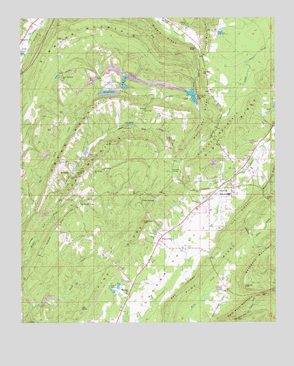
Odenville, AL USGS Topographic Map
Click on map above to begin viewing in our Map Viewer.

This topographic map contains these locations and features:
Feature Name Type Latitude Longitude GNIS ID View Map
Acmar MinesMineN33.6348°W86.4875°165000View Map
Anderson MountainSummitN33.6662°W86.4405°164537View Map
Austin Olds CemeteryCemeteryN33.6751°W86.4744°164541View Map
Beulah ChurchChurchN33.6868°W86.4730°164559View Map
BranchvillePopulated PlaceN33.7000°W86.4000°164576View Map
Branchville CemeteryCemeteryN33.6587°W86.4353°1805555View Map
Branchville Police DepartmentBuildingN33.6581°W86.4313°2752010View Map
Brookston MineMineN33.6932°W86.4291°165019View Map
Buzzard RoostCliffN33.7372°W86.4166°164583View Map
Clayton DamDamN33.6384°W86.4033°164944View Map
Clayton LakeReservoirN33.6389°W86.4028°164943View Map
Coal MountainSummitN33.6998°W86.4425°164609View Map
Copper SpringsPopulated PlaceN33.6737°W86.4408°164617View Map
Copper Springs ChurchChurchN33.6770°W86.4414°165042View Map
CrockertownPopulated PlaceN33.6709°W86.4097°165045View Map
Crooked CreekStreamN33.7348°W86.4128°164623View Map
Denman SpringSpringN33.6873°W86.4230°164628View Map
Dry CreekStreamN33.7301°W86.4153°164635View Map
Ebenezer Baptist ChurchChurchN33.6373°W86.4475°164641View Map
Elbow GapGapN33.6373°W86.3816°164643View Map
Foremans MineMineN33.6918°W86.4472°165072View Map
Friendship ChurchChurchN33.7062°W86.3753°165074View Map
Goodwill ChurchChurchN33.7273°W86.4108°164670View Map
Green Acres EstatesPopulated PlaceN33.6612°W86.4278°165078View Map
Grindstone BranchStreamN33.6595°W86.3855°164677View Map
Havilah Hills EstatesPopulated PlaceN33.6862°W86.4147°165085View Map
High PointSummitN33.6262°W86.3958°164700View Map
Hill Number 1Populated PlaceN33.6857°W86.4689°165092View Map
Hill Number 2Populated PlaceN33.6876°W86.4833°165093View Map
Howell LakeReservoirN33.7473°W86.4181°164707View Map
Independence ChurchChurchN33.7068°W86.4933°165319View Map
Jolly SpringSpringN33.6307°W86.4703°164714View Map
Jones School (historical)SchoolN33.7195°W86.4069°165107View Map
Jump-Off RockSummitN33.6401°W86.3903°164717View Map
L and M DamDamN33.7213°W86.4501°164961View Map
L and M LakeReservoirN33.7238°W86.4490°164962View Map
Lake MelanieReservoirN33.6251°W86.4663°164941View Map
Lake RiddleReservoirN33.7064°W86.4458°164833View Map
Lazy V LakeReservoirN33.6399°W86.4523°164727View Map
Lazy V Lake AcresPopulated PlaceN33.6368°W86.4514°165112View Map
Lazy V Ranch DamDamN33.6401°W86.4533°164945View Map
Liberty CemeteryCemeteryN33.6929°W86.3883°1805538View Map
Liberty ChurchChurchN33.6918°W86.3880°165115View Map
Low GapLocaleN33.7129°W86.4397°164745View Map
Low Gap CemeteryCemeteryN33.7137°W86.4386°1805624View Map
Low Gap United Methodist ChurchChurchN33.7126°W86.4380°165122View Map
Macedonia Baptist ChurchChurchN33.6918°W86.4814°164747View Map
Macedonia CemeteryCemeteryN33.6923°W86.4805°1805539View Map
MargaretPopulated PlaceN33.6862°W86.4750°164749View Map
Margaret LakeReservoirN33.6952°W86.4676°165126View Map
Margaret MineMineN33.6848°W86.4444°165127View Map
Margaret Post OfficePost OfficeN33.6856°W86.4758°167268View Map
Margaret School (historical)SchoolN33.6887°W86.4828°165303View Map
Margaret Volunteer Fire DepartmentBuildingN33.6828°W86.4772°2683345View Map
Martin DamDamN33.6951°W86.4883°164955View Map
Martin LakeReservoirN33.6942°W86.4879°164954View Map
Mount Avery ChurchChurchN33.6868°W86.4647°164764View Map
New Hope ChurchChurchN33.6882°W86.4605°164778View Map
New Lebanon ChurchChurchN33.7254°W86.4800°164780View Map
New Life ChurchChurchN33.6518°W86.4275°165323View Map
Oak RidgeRidgeN33.6548°W86.4036°164790View Map
OdenvillePopulated PlaceN33.6773°W86.3966°164791View Map
Odenville Fire and RescueBuildingN33.6826°W86.3982°2682833View Map
Odenville Fire and Rescue Station 2BuildingN33.7141°W86.4398°2683346View Map
Odenville Fire and Rescue Station 3BuildingN33.6588°W86.4315°2683343View Map
Odenville Industrial ParkLocaleN33.6793°W86.4555°165158View Map
Odenville Post OfficePost OfficeN33.6795°W86.4030°2789069View Map
Pine RidgeRidgeN33.6470°W86.4053°164804View Map
Pine RidgeRidgeN33.6801°W86.4266°164805View Map
Qsl Fish Hatchery DamDamN33.6501°W86.3983°164946View Map
Qsl Fish Hatchery LakeReservoirN33.6501°W86.3983°164947View Map
Riddle DamDamN33.7068°W86.4466°164958View Map
Saint Clair Correctional FacilityBuildingN33.7452°W86.3840°2739753View Map
Saint Clair County High SchoolSchoolN33.6773°W86.3978°165157View Map
SaniePopulated PlaceN33.6604°W86.4789°164846View Map
Sanie Missionary Baptist ChurchChurchN33.6618°W86.4803°165191View Map
Shady AcresPopulated PlaceN33.6501°W86.4533°165196View Map
Side SpringSpringN33.7448°W86.4039°164857View Map
Simmons MountainSummitN33.7398°W86.4825°164858View Map
Springville ChurchChurchN33.7409°W86.4997°164864View Map
Springville DivisionCivilN33.7387°W86.4307°165946View Map
Springville Fire and Rescue Station 2BuildingN33.7363°W86.4820°2683371View Map
Springville Sportsman DamDamN33.7201°W86.4150°164960View Map
Springville Sportsmen LakeReservoirN33.7184°W86.4162°164866View Map
Stovall BranchStreamN33.7226°W86.3919°164872View Map
Stovall MountainSummitN33.7018°W86.4033°164873View Map
Town & Country AirparkAirportN33.6581°W86.4133°2676323View Map
Town of Branchville (historical)CivilN33.7000°W86.4000°2405312View Map
Town of MargaretCivilN33.6735°W86.4680°2406094View Map
Town of OdenvilleCivilN33.6978°W86.4229°2407036View Map
Trucks DamDamN33.7184°W86.4618°164959View Map
Trucks LakeReservoirN33.7194°W86.4566°164892View Map
Truss Mill (historical)LocaleN33.7318°W86.3880°165213View Map
Turnbough TownPopulated PlaceN33.6745°W86.4697°164895View Map
Watkins CutGapN33.6754°W86.3794°164902View Map
Wolf Pen RidgeRidgeN33.7065°W86.4094°164915View Map
Woody AcresPopulated PlaceN33.6315°W86.4611°165229View Map

Note: Coordinates in the location and feature list above are referenced to NAD83 datum.


Copyright (C) 2008-2025 Ryan Niemi / Sunset Dynamics ... All Rights Reserved