TopoQuest Logo
Do you find TopoQuest useful?
Help keep TopoQuest running and adding new maps/features by donating!
Bitcoin:  19c7KJd3qBynnjoSw5npx9KScwjBe4ifkT
Litecoin:  LXs6TkuXGGXo1vDsWCkWVdjQX94eUKd6ui
Home View Maps Find Maps Find Places Resources & Links


Reno Beach, Ohio Topographic Map

USGS Map Title: Reno Beach, OH
USGS Map MRC: 41083F3
DRG (GeoTIFF) Download: o41083f3.tif


Neighboring USGS Topographic Map Quads:


  Erie, MI  
41083G4


  Oregon, OH  
41083F4
 

  Reno Beach, OH  
41083F3
 

  Metzger Marsh, OH  
41083F2
 

  Walbridge, OH  
41083E4
 

  Genoa, OH  
41083E3
 

  Oak Harbor, OH  
41083E2


Map MRC Location:

N42°
W84°
N42°
W83°
H8 H7 H6 H5 H4 H3 H2 H1
G8 G7 G6 G5 G4 G3 G2 G1
F8 F7 F6 F5 F4 F3 F2 F1
E8 E7 E6 E5 E4 E3 E2 E1
D8 D7 D6 D5 D4 D3 D2 D1
C8 C7 C6 C5 C4 C3 C2 C1
B8 B7 B6 B5 B4 B3 B2 B1
A8 A7 A6 A5 A4 A3 A2 A1
N41°
W84°
N41°
W83°

Reno Beach, OH USGS 1:24K Topographic Map Preview:
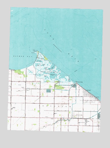
Reno Beach, OH USGS Topographic Map
Click on map above to begin viewing in our Map Viewer.

This topographic map contains these locations and features:
Feature Name Type Latitude Longitude GNIS ID View Map
Anchor Point MarinaLocaleN41.6720°W83.2860°1806375View Map
Back of Howells PondReservoirN41.6902°W83.3167°1037565View Map
Berger Road DitchCanalN41.6637°W83.3713°1067125View Map
BonoPopulated PlaceN41.6356°W83.2691°1056226View Map
Bono Post Office (historical)Post OfficeN41.6362°W83.2694°2026625View Map
Carrington PondReservoirN41.6987°W83.3338°1038834View Map
Cedar CreekStreamN41.6745°W83.2847°1083974View Map
Cedar Creek PondReservoirN41.6919°W83.3378°1038891View Map
Cedar PointCapeN41.7062°W83.3435°1038908View Map
Cedar Point Clubhouse (historical)BuildingN41.7039°W83.3360°1806376View Map
Cedar Point MarshSwampN41.6924°W83.3293°1806377View Map
Cedar Point National Wildlife RefugeParkN41.6871°W83.3204°1038911View Map
Eisenhower Intermediate SchoolSchoolN41.6467°W83.3695°1056273View Map
Goose PondLakeN41.6737°W83.3335°1806379View Map
Hannah Pond (historical)LakeN41.6752°W83.2970°1067454View Map
Haskell Pond (historical)LakeN41.6723°W83.2999°1079559View Map
Jerusalem Township Fire DepartmentBuildingN41.6389°W83.3202°2549766View Map
Lacourse PondReservoirN41.6798°W83.3237°1042364View Map
LakelandPopulated PlaceN41.6600°W83.2577°1056392View Map
Lakemont LandingPopulated PlaceN41.6731°W83.2805°1048900View Map
Lamb BeachBeachN41.7000°W83.3249°1806380View Map
Long PondReservoirN41.6964°W83.3355°1042747View Map
Mallard Club MarshSwampN41.6845°W83.3460°1806381View Map
Mallard Club Marsh State Wildlife AreaParkN41.6792°W83.3458°1806382View Map
New Jerusalem (historical)Populated PlaceN41.6389°W83.3027°1070565View Map
Niles BeachPopulated PlaceN41.6864°W83.3699°1065155View Map
Niles Pond (historical)LakeN41.6750°W83.3166°1067456View Map
Oregon City Filtration PlantLocaleN41.6689°W83.3722°2740808View Map
Our Lady of Mount Carmel ChurchChurchN41.6345°W83.2783°1056469View Map
Outlet PondReservoirN41.6985°W83.3285°1044244View Map
Paynes PondBayN41.6767°W83.2927°1067457View Map
Pintail PondReservoirN41.6888°W83.3272°1044481View Map
Potters PondBayN41.6784°W83.2916°1067156View Map
Reno BeachPopulated PlaceN41.6634°W83.2694°1049117View Map
Reno Side CutCanalN41.6534°W83.2849°1067129View Map
Saint Lukes ChurchChurchN41.6389°W83.3205°1045617View Map
Sautter DitchCanalN41.6620°W83.3519°1048444View Map
Scottish Links Golf CourseLocaleN41.6792°W83.3666°1962930View Map
Secor BayBayN41.6814°W83.3027°1067458View Map
Suzar BayBayN41.6834°W83.3235°1067130View Map
Wards CanalCanalN41.6389°W83.2646°1067132View Map
WDHO Radio TowerTowerN41.6678°W83.3555°1080473View Map
Widgeon PondReservoirN41.6917°W83.3306°1047896View Map
Williams DitchCanalN41.6675°W83.2927°1047928View Map
WNWO-TV (Toledo)TowerN41.6675°W83.3560°1083934View Map
Wolf CreekStreamN41.6756°W83.2844°1067064View Map
Wolf Creek PondLakeN41.6859°W83.3214°1065465View Map
YondotaPopulated PlaceN41.6384°W83.3122°1049355View Map
Yondota Post Office (historical)Post OfficeN41.6389°W83.3124°2027305View Map

Note: Coordinates in the location and feature list above are referenced to NAD83 datum.


Copyright (C) 2008-2024 Ryan Niemi / Sunset Dynamics ... All Rights Reserved