TopoQuest Logo
Do you find TopoQuest useful?
Help keep TopoQuest running and adding new maps/features by donating!
Bitcoin:  19c7KJd3qBynnjoSw5npx9KScwjBe4ifkT
Litecoin:  LXs6TkuXGGXo1vDsWCkWVdjQX94eUKd6ui
Home View Maps Find Maps Find Places Resources & Links


Oak Harbor, Ohio Topographic Map

USGS Map Title: Oak Harbor, OH
USGS Map MRC: 41083E2
DRG (GeoTIFF) Download: o41083e2.tif


Neighboring USGS Topographic Map Quads:


  Reno Beach, OH  
41083F3
 

  Metzger Marsh, OH  
41083F2


  Genoa, OH  
41083E3
 

  Oak Harbor, OH  
41083E2
 

  Lacarne, OH  
41083E1
 

  Elmore, OH  
41083D3
 

  Lindsey, OH  
41083D2
 

  Wightmans Grove, OH  
41083D1


Map MRC Location:

N42°
W84°
N42°
W83°
H8 H7 H6 H5 H4 H3 H2 H1
G8 G7 G6 G5 G4 G3 G2 G1
F8 F7 F6 F5 F4 F3 F2 F1
E8 E7 E6 E5 E4 E3 E2 E1
D8 D7 D6 D5 D4 D3 D2 D1
C8 C7 C6 C5 C4 C3 C2 C1
B8 B7 B6 B5 B4 B3 B2 B1
A8 A7 A6 A5 A4 A3 A2 A1
N41°
W84°
N41°
W83°

Oak Harbor, OH USGS 1:24K Topographic Map Preview:
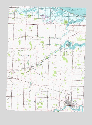
Oak Harbor, OH USGS Topographic Map
Click on map above to begin viewing in our Map Viewer.

This topographic map contains these locations and features:
Feature Name Type Latitude Longitude GNIS ID View Map
Big Sand BayBayN41.6223°W83.1733°1037997View Map
Carroll Township Emergency Medical and Fire ServicesBuildingN41.5666°W83.1468°2549673View Map
Carroll Township PoliceBuildingN41.5665°W83.1471°2732787View Map
Carroll Township SchoolSchoolN41.5675°W83.1458°1049683View Map
Continental MarshSwampN41.6215°W83.2243°1806457View Map
Crane Creek State ParkParkN41.6212°W83.1610°1039449View Map
Eisenhour MarshSwampN41.6164°W83.2248°1806460View Map
France MarshSwampN41.6083°W83.1800°1806461View Map
Hunter MarshSwampN41.6166°W83.2342°1806462View Map
LimestonePopulated PlaceN41.5525°W83.2124°1042571View Map
Limestone CemeteryCemeteryN41.5592°W83.2169°1964662View Map
Limestone Post Office (historical)Post OfficeN41.5528°W83.2124°2041507View Map
Locust PointCapeN41.6164°W83.1277°1042705View Map
Magee MarshSwampN41.6126°W83.1716°1806463View Map
Magee Marsh Wildlife AreaParkN41.6142°W83.1638°1067128View Map
Maple Grove (historical)Populated PlaceN41.5892°W83.1980°1049682View Map
Mid County Emergency Medical ServicesBuildingN41.5147°W83.1491°2550840View Map
Moore OrchardsLocaleN41.5908°W83.1331°2518655View Map
Oak HarborPopulated PlaceN41.5067°W83.1466°1065474View Map
Oak Harbor High SchoolSchoolN41.5137°W83.1568°1049685View Map
Oak Harbor Middle SchoolSchoolN41.5127°W83.1480°1049686View Map
Oak Harbor Post OfficePost OfficeN41.5087°W83.1471°1082337View Map
Oak Harbor Public LibraryBuildingN41.5087°W83.1469°1077371View Map
Oak Harbor United Methodist ChurchChurchN41.5103°W83.1371°1731464View Map
Oak Harbor Village PoliceBuildingN41.5091°W83.1472°2732730View Map
Ottawa National Wildlife RefugeParkN41.6214°W83.2203°1044211View Map
Packer CreekStreamN41.5778°W83.1624°1057906View Map
Portage Fire DistrictBuildingN41.5079°W83.1488°2549680View Map
R C Waters Elementary SchoolSchoolN41.5103°W83.1408°1082011View Map
Ritter MarshSwampN41.6198°W83.2063°1806465View Map
Rocky RidgePopulated PlaceN41.5334°W83.2124°1061627View Map
Rocky Ridge Elementary SchoolSchoolN41.5325°W83.2160°1049681View Map
Rocky Ridge QuarryMineN41.5586°W83.2158°2567605View Map
Rocky Ridge Volunteer Fire DepartmentBuildingN41.5324°W83.2139°2549678View Map
Rockyridge Post OfficePost OfficeN41.5320°W83.2127°1082336View Map
Saint Boniface Catholic ChurchChurchN41.5109°W83.1480°1731465View Map
Saint Boniface Elementary SchoolSchoolN41.5108°W83.1483°1731466View Map
Saint Johns Evangelical Lutheran ChurchChurchN41.5103°W83.1474°1731467View Map
Saint Joseph CemeteryCemeteryN41.5869°W83.1642°1045334View Map
Saint Paul United Church of ChristChurchN41.5098°W83.1521°1807368View Map
Sportsmen Migratory Bird CenterBuildingN41.6114°W83.1910°1806467View Map
Toussaint CreekStreamN41.5778°W83.1621°1047097View Map
Toussaint Creek Wildlife AreaParkN41.5787°W83.1538°1047098View Map
Township of BentonCivilN41.5696°W83.2414°1086756View Map
Turtle CreekStreamN41.6153°W83.1285°1047222View Map
Turtle Creek BayBayN41.6089°W83.1394°1047223View Map
Turtle Creek Lake AreaParkN41.6075°W83.1571°1047224View Map
Union CemeteryCemeteryN41.5064°W83.1571°1049684View Map
Village of Oak HarborCivilN41.5073°W83.1428°2399536View Map
Village of Rocky RidgeCivilN41.5309°W83.2126°2399109View Map
Wolf CreekStreamN41.5009°W83.1663°1048029View Map

Note: Coordinates in the location and feature list above are referenced to NAD83 datum.


Copyright (C) 2008-2025 Ryan Niemi / Sunset Dynamics ... All Rights Reserved