TopoQuest Logo
Do you find TopoQuest useful?
Help keep TopoQuest running and adding new maps/features by donating!
Bitcoin:  19c7KJd3qBynnjoSw5npx9KScwjBe4ifkT
Litecoin:  LXs6TkuXGGXo1vDsWCkWVdjQX94eUKd6ui
Home View Maps Find Maps Find Places Resources & Links


Richmond, Maine Topographic Map

USGS Map Title: Richmond, ME
USGS Map MRC: 44069A7
DRG (GeoTIFF) Download: o44069a7.tif


Neighboring USGS Topographic Map Quads:


  Purgatory, ME  
44069B8
 

  Gardiner, ME  
44069B7
 

  East Pittston, ME  
44069B6
 

  Bowdoinham, ME  
44069A8
 

  Richmond, ME  
44069A7
 

  Wiscasset, ME  
44069A6
 

  Brunswick, ME  
43069H8
 

  Bath, ME  
43069H7
 

  Westport, ME  
43069H6


Map MRC Location:

N45°
W70°
N45°
W69°
H8 H7 H6 H5 H4 H3 H2 H1
G8 G7 G6 G5 G4 G3 G2 G1
F8 F7 F6 F5 F4 F3 F2 F1
E8 E7 E6 E5 E4 E3 E2 E1
D8 D7 D6 D5 D4 D3 D2 D1
C8 C7 C6 C5 C4 C3 C2 C1
B8 B7 B6 B5 B4 B3 B2 B1
A8 A7 A6 A5 A4 A3 A2 A1
N44°
W70°
N44°
W69°

Richmond, ME USGS 1:24K Topographic Map Preview:
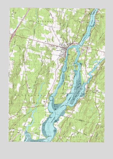
Richmond, ME USGS Topographic Map
Click on map above to begin viewing in our Map Viewer.

This topographic map contains these locations and features:
Feature Name Type Latitude Longitude GNIS ID View Map
Abagadasset PointCapeN44.0048°W69.8245°561038View Map
Abagadasset RiverStreamN44.0098°W69.8517°561039View Map
Ames LedgeBarN44.0192°W69.8145°561234View Map
Baker BrookStreamN44.0676°W69.8239°561454View Map
Beef RockIslandN44.0473°W69.7914°581683View Map
Big PondReservoirN44.0460°W69.8014°562225View Map
Brown Point CemeteryCemeteryN44.0081°W69.8400°563060View Map
C H T J Southard House MuseumBuildingN44.0881°W69.8045°1907779View Map
Call CemeteryCemeteryN44.0639°W69.7905°563360View Map
Carney PointCapeN44.0334°W69.7981°563581View Map
Cedar GrovePopulated PlaceN44.1162°W69.7631°580770View Map
Clay CoveBayN44.0756°W69.8023°564063View Map
Cooksey ChannelChannelN44.0476°W69.7898°580226View Map
Cork CoveBayN44.0448°W69.7770°564365View Map
Cotton CemeteryCemeteryN44.0897°W69.8172°564390View Map
Courthouse PointCapeN44.1073°W69.7667°564396View Map
Curtis CemeteryCemeteryN44.1184°W69.8209°564680View Map
Denham StreamStreamN44.0340°W69.8742°580407View Map
Dinsmore CemeteryCemeteryN44.0501°W69.8494°565118View Map
Dram RockIslandN44.0301°W69.8137°565278View Map
Dresden Volunteer Fire Department Station 2BuildingN44.0876°W69.7719°2552974View Map
Eastern RiverStreamN44.0501°W69.7775°565736View Map
Evergreen CemeteryCemeteryN44.0965°W69.8075°565965View Map
Farm PondsReservoirN44.0540°W69.7942°566046View Map
Forest Hill CemeteryCemeteryN44.0874°W69.7748°566400View Map
Gaubert CemeteryCemeteryN44.1121°W69.7814°566722View Map
Goodwin PointCapeN44.0756°W69.7848°580225View Map
Green PointCapeN44.0545°W69.7795°567252View Map
HarwardsPopulated PlaceN44.0342°W69.8267°579389View Map
Harwards CemeteryCemeteryN44.0337°W69.8265°2736983View Map
Hatch PointCapeN44.0648°W69.8017°567749View Map
Hatchs CornerPopulated PlaceN44.0479°W69.7614°567754View Map
IceboroPopulated PlaceN44.1123°W69.7787°579428View Map
Interchange 26CrossingN44.1001°W69.8700°1907818View Map
Isaac F Umberhine Public LibraryBuildingN44.0887°W69.8045°1907819View Map
Lillys CoveBayN44.0104°W69.8137°569552View Map
Little RiverStreamN44.0648°W69.7870°570008View Map
Little SwanIslandN44.0706°W69.7870°580788View Map
Lovejoy NarrowsChannelN44.0740°W69.7862°570442View Map
Maple Grove CemeteryCemeteryN44.0476°W69.7626°570723View Map
Marcia Buker SchoolSchoolN44.0853°W69.8064°563148View Map
Maxwell CemeteryCemeteryN44.0375°W69.8266°570925View Map
Maxwell CoveBayN44.0442°W69.7978°570928View Map
Maxwell IslandIslandN44.0229°W69.8214°570929View Map
Middle GroundBarN44.0509°W69.7834°580306View Map
Mill BrookStreamN44.0892°W69.7959°571295View Map
Perkins Township Swan IslandCivilN44.0619°W69.7960°1987386View Map
Plumer CemeteryCemeteryN44.1200°W69.8681°573529View Map
Pork PointCapeN44.0267°W69.8195°573674View Map
Randall CemeteryCemeteryN44.0087°W69.8606°574028View Map
Reed RockBarN44.0665°W69.7825°574130View Map
RichmondPopulated PlaceN44.0873°W69.7989°574174View Map
Richmond Census Designated PlaceCensusN44.1056°W69.8117°2377951View Map
Richmond Fire DepartmentBuildingN44.0880°W69.8054°2552698View Map
Richmond High SchoolSchoolN44.0876°W69.8122°1907858View Map
Richmond Historic DistrictParkN44.0848°W69.8025°1907859View Map
Richmond Historical SocietyBuildingN44.0862°W69.8025°1907860View Map
Richmond Middle SchoolSchoolN44.0873°W69.8122°1907861View Map
Richmond Police DepartmentBuildingN44.0861°W69.8058°2735842View Map
Richmond Post OfficePost OfficeN44.0885°W69.8067°1907857View Map
Robert P Tristam Coffin Wildflower SanctuaryParkN44.0126°W69.7995°1907862View Map
Saint Alexander Nevsky ChurchChurchN44.0867°W69.8003°1907866View Map
Saint Matthias ChurchChurchN44.0859°W69.8039°1907868View Map
Shepherd of the Faith ChurchChurchN44.0881°W69.8048°1907874View Map
Shipyard PointCapeN44.0479°W69.7937°575419View Map
Small CemeteryCemeteryN44.0558°W69.8516°2737002View Map
South DresdenPopulated PlaceN44.0492°W69.7720°575836View Map
Southard PointCapeN44.0812°W69.7992°575930View Map
Stearns PointCapeN44.0879°W69.7828°576292View Map
Steve Powell Wildlife Management AreaParkN44.0648°W69.7992°576316View Map
Stiphinin PointCapeN44.0387°W69.8212°576362View Map
Swan IslandIslandN44.0590°W69.7950°576576View Map
Swan Island CemeteryCemeteryN44.0672°W69.7947°2737005View Map
Swan Island FlatsFlatN44.0334°W69.8137°580227View Map
Swan Island PointCapeN44.0359°W69.8142°576577View Map
Theobald PointCapeN44.0417°W69.8159°576942View Map
Town of BowdoinhamCivilN44.0346°W69.8695°582361View Map
Town of RichmondCivilN44.1237°W69.8288°582695View Map
Twing PointCapeN44.0167°W69.8162°577490View Map
Ukranian Orthodox ChurchChurchN44.0809°W69.8056°1907888View Map
United Methodist ChurchChurchN44.0817°W69.8023°1907890View Map
Unorganized Territory of PerkinsCivilN44.0575°W69.7986°582671View Map
Wade CoveBayN44.0579°W69.8028°577752View Map
Wade PondLakeN44.0628°W69.7961°577753View Map
Webbs PointCapeN44.0423°W69.7778°577941View Map
West DresdenPopulated PlaceN44.0879°W69.7725°578128View Map
Whitmore CemeteryCemeteryN44.0449°W69.8233°2737008View Map
Woolwich Volunteer Fire Department North StationBuildingN44.0059°W69.7721°2553122View Map

Note: Coordinates in the location and feature list above are referenced to NAD83 datum.


Copyright (C) 2008-2024 Ryan Niemi / Sunset Dynamics ... All Rights Reserved