TopoQuest Logo
Do you find TopoQuest useful?
Help keep TopoQuest running and adding new maps/features by donating!
Bitcoin:  19c7KJd3qBynnjoSw5npx9KScwjBe4ifkT
Litecoin:  LXs6TkuXGGXo1vDsWCkWVdjQX94eUKd6ui
Home View Maps Find Maps Find Places Resources & Links


Gardiner, Maine Topographic Map

USGS Map Title: Gardiner, ME
USGS Map MRC: 44069B7
DRG (GeoTIFF) Download: o44069b7.tif


Neighboring USGS Topographic Map Quads:


  Winthrop, ME  
44069C8
 

  Augusta, ME  
44069C7
 

  Togus Pond, ME  
44069C6
 

  Purgatory, ME  
44069B8
 

  Gardiner, ME  
44069B7
 

  East Pittston, ME  
44069B6
 

  Bowdoinham, ME  
44069A8
 

  Richmond, ME  
44069A7
 

  Wiscasset, ME  
44069A6


Map MRC Location:

N45°
W70°
N45°
W69°
H8 H7 H6 H5 H4 H3 H2 H1
G8 G7 G6 G5 G4 G3 G2 G1
F8 F7 F6 F5 F4 F3 F2 F1
E8 E7 E6 E5 E4 E3 E2 E1
D8 D7 D6 D5 D4 D3 D2 D1
C8 C7 C6 C5 C4 C3 C2 C1
B8 B7 B6 B5 B4 B3 B2 B1
A8 A7 A6 A5 A4 A3 A2 A1
N44°
W70°
N44°
W69°

Gardiner, ME USGS 1:24K Topographic Map Preview:
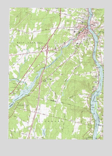
Gardiner, ME USGS Topographic Map
Click on map above to begin viewing in our Map Viewer.

This topographic map contains these locations and features:
Feature Name Type Latitude Longitude GNIS ID View Map
Adkins PointCapeN44.1928°W69.7584°561096View Map
American Tissue DamDamN44.2218°W69.7858°1773677View Map
Babb CemeteryCemeteryN44.2098°W69.8180°2736349View Map
Beedle Road ChurchChurchN44.1431°W69.7928°562002View Map
Blanchard CemeteryCemeteryN44.2418°W69.7662°579887View Map
Brown Family CemeteryCemeteryN44.1442°W69.8749°2736971View Map
Christ Church CemeteryCemeteryN44.2274°W69.7745°2736697View Map
Christ Church CenotaphsCemeteryN44.2276°W69.7746°2736698View Map
City of GardinerCivilN44.1910°W69.7921°582486View Map
Cobbosseecontee StreamStreamN44.2306°W69.7712°564127View Map
Cobbosseecontee Stream ReservoirReservoirN44.2202°W69.7897°1773678View Map
Colburn House State Memorial (historical)BuildingN44.1981°W69.7550°579863View Map
Cold StreamStreamN44.1812°W69.8645°564198View Map
Coss Hill CemeteryCemeteryN44.1530°W69.7541°2736763View Map
Eastman PointCapeN44.1556°W69.7662°579870View Map
Fairbanks CemeteryCemeteryN44.2275°W69.8607°579877View Map
FarmingdalePopulated PlaceN44.2445°W69.7714°566053View Map
Farmingdale ShoalBarN44.2484°W69.7698°581736View Map
Farmingdale Volunteer Fire Department Central StationBuildingN44.2410°W69.7707°2553001View Map
GardinerPopulated PlaceN44.2301°W69.7753°566690View Map
Gardiner Area High SchoolSchoolN44.2274°W69.7890°2737994View Map
Gardiner Fire DepartmentBuildingN44.2285°W69.7722°2552794View Map
Gardiner Police DepartmentBuildingN44.2293°W69.7716°2735878View Map
Gardiner Post OfficePost OfficeN44.2297°W69.7743°2789363View Map
Gardiner Public LibraryBuildingN44.2288°W69.7709°2738329View Map
Gardiner Regional Middle SchoolSchoolN44.2168°W69.8020°2737995View Map
Goodwin PointCapeN44.1653°W69.7584°566901View Map
Greens LedgeBarN44.1990°W69.7595°581752View Map
Grover BrookStreamN44.2103°W69.8517°567356View Map
Hathorn RockBarN44.1345°W69.7598°581774View Map
Indian PointCapeN44.1429°W69.7617°568591View Map
Interchange 14CrossingN44.2117°W69.8312°581578View Map
Iron Mine HillSummitN44.2128°W69.7853°568674View Map
Kendall ChapelChurchN44.1723°W69.8506°579872View Map
Lapham CemeteryCemeteryN44.2052°W69.7577°2736735View Map
Laura E Richards SchoolSchoolN44.2188°W69.7814°2737992View Map
Libby HillPopulated PlaceN44.1826°W69.8256°569528View Map
Libby Hill CemeteryCemeteryN44.1801°W69.8256°579873View Map
Lyons CoveBayN44.2440°W69.7662°579890View Map
Maple Grove CemeteryCemeteryN44.2337°W69.7662°579884View Map
Morton BrookStreamN44.1909°W69.7523°571712View Map
Mount Hope CemeteryCemeteryN44.1795°W69.7587°579875View Map
Nehumkeag (historical)Populated PlaceN44.1695°W69.7534°579936View Map
Nehumkeag IslandIslandN44.1698°W69.7584°579874View Map
New Mills DamDamN44.2202°W69.7897°1773679View Map
Oak Grove CemeteryCemeteryN44.2198°W69.7764°579880View Map
Peacock Beach State ParkParkN44.1570°W69.8592°579866View Map
PittstonPopulated PlaceN44.2217°W69.7556°579892View Map
Pittston Consolidated SchoolSchoolN44.2216°W69.7554°579882View Map
Pittston Fire Department Central StationBuildingN44.2237°W69.7544°2552902View Map
Pleasant PondLakeN44.1642°W69.8637°579937View Map
Pleasant PondReservoirN44.2201°W69.7895°1773680View Map
Pleasant Pond Boat Facility (historical)LocaleN44.1706°W69.8453°581625View Map
Plummer Street SchoolSchoolN44.2237°W69.7770°579881View Map
Pray Street SchoolSchoolN44.2295°W69.7845°579886View Map
RandolphPopulated PlaceN44.2303°W69.7667°574035View Map
Randolph Census Designated PlaceCensusN44.2347°W69.7506°2377950View Map
Randolph Fire DepartmentBuildingN44.2298°W69.7664°2552998View Map
Reed CemeteryCemeteryN44.1267°W69.8308°574119View Map
Richmond Camp GroundLocaleN44.1256°W69.7714°574175View Map
Ring HillSummitN44.1567°W69.8533°574221View Map
River View Community SchoolSchoolN44.1752°W69.7596°2737993View Map
Riverside CemeteryCemeteryN44.1448°W69.7546°579869View Map
Riverside CemeteryCemeteryN44.1954°W69.7512°579876View Map
Rolling Dam BrookStreamN44.1976°W69.7609°574438View Map
Saint Josephs CemeteryCemeteryN44.2187°W69.7756°574732View Map
Sheldon Street School (historical)SchoolN44.2403°W69.7784°2630663View Map
Skin CoveBayN44.2178°W69.7581°579889View Map
South GardinerPopulated PlaceN44.1801°W69.7567°575842View Map
South Gardiner CemeteryCemeteryN44.1846°W69.7572°579893View Map
South Gardner Post OfficePost OfficeN44.1844°W69.7571°2768958View Map
Tarbox FlatsFlatN44.2201°W69.7628°579879View Map
Teresa C Hamlin Elementary SchoolSchoolN44.2342°W69.7668°579888View Map
The BluffCliffN44.1256°W69.7570°579868View Map
The Sands IslandIslandN44.1562°W69.7609°576920View Map
Togus StreamStreamN44.2242°W69.7595°577162View Map
Town of RandolphCivilN44.2347°W69.7506°582689View Map
Town of West GardinerCivilN44.2242°W69.8720°582806View Map
Trotts PointCapeN44.1484°W69.7637°577317View Map
Umberhind MarshLakeN44.1313°W69.8278°579867View Map
Upper Sands ShoalBarN44.1617°W69.7623°579871View Map
WABK Radio Tower (Havre De Grace)TowerN44.2487°W69.8134°579878View Map
West Gardiner Fire Department Station 2BuildingN44.1866°W69.8485°2553203View Map
West Hill CemeteryCemeteryN44.2314°W69.7884°579885View Map
WFAU-AM (Gardiner)TowerN44.2489°W69.8132°582272View Map
Wilmot BrookStreamN44.1526°W69.7664°578535View Map
Woodman Junior High SchoolSchoolN44.2273°W69.7737°579883View Map

Note: Coordinates in the location and feature list above are referenced to NAD83 datum.


Copyright (C) 2008-2024 Ryan Niemi / Sunset Dynamics ... All Rights Reserved