TopoQuest Logo
Do you find TopoQuest useful?
Help keep TopoQuest running and adding new maps/features by donating!
Bitcoin:  19c7KJd3qBynnjoSw5npx9KScwjBe4ifkT
Litecoin:  LXs6TkuXGGXo1vDsWCkWVdjQX94eUKd6ui
Home View Maps Find Maps Find Places Resources & Links


Purgatory, Maine Topographic Map

USGS Map Title: Purgatory, ME
USGS Map MRC: 44069B8
DRG (GeoTIFF) Download: o44069b8.tif


Neighboring USGS Topographic Map Quads:


  Wayne, ME  
44070C1
 

  Winthrop, ME  
44069C8
 

  Augusta, ME  
44069C7
 

  Monmouth, ME  
44070B1
 

  Purgatory, ME  
44069B8
 

  Gardiner, ME  
44069B7
 

  Lisbon Falls North, ME  
44070A1
 

  Bowdoinham, ME  
44069A8
 

  Richmond, ME  
44069A7


Map MRC Location:

N45°
W70°
N45°
W69°
H8 H7 H6 H5 H4 H3 H2 H1
G8 G7 G6 G5 G4 G3 G2 G1
F8 F7 F6 F5 F4 F3 F2 F1
E8 E7 E6 E5 E4 E3 E2 E1
D8 D7 D6 D5 D4 D3 D2 D1
C8 C7 C6 C5 C4 C3 C2 C1
B8 B7 B6 B5 B4 B3 B2 B1
A8 A7 A6 A5 A4 A3 A2 A1
N44°
W70°
N44°
W69°

Purgatory, ME USGS 1:24K Topographic Map Preview:
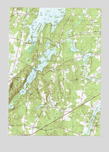
Purgatory, ME USGS Topographic Map
Click on map above to begin viewing in our Map Viewer.

This topographic map contains these locations and features:
Feature Name Type Latitude Longitude GNIS ID View Map
Allard CemeteryCemeteryN44.1344°W69.8810°2736967View Map
Annabessacook DamDamN44.2420°W69.9771°1773683View Map
Ashford BrookStreamN44.1479°W69.9267°561324View Map
Ballard BayBayN44.2309°W69.9567°561549View Map
Batchelders CrossingPopulated PlaceN44.1898°W69.9398°579122View Map
Black Ash SwampSwampN44.1609°W69.8931°562383View Map
Blue Bell IslandIslandN44.2259°W69.9701°562590View Map
Browns CornerPopulated PlaceN44.2259°W69.8978°579157View Map
Buker PondLakeN44.1676°W69.9803°563147View Map
Carrie Ricker Middle SchoolSchoolN44.1326°W69.9721°569649View Map
Cobbosseecontee LakeReservoirN44.2428°W69.9516°564126View Map
Cobbosseecontee Stream ReservoirReservoirN44.2461°W69.8948°1774359View Map
Collins DamDamN44.2461°W69.8948°1774358View Map
Dennis BrookStreamN44.2070°W69.9184°565039View Map
Dennis HillSummitN44.1906°W69.9220°565041View Map
Dilnow BrookStreamN44.2004°W69.9995°565105View Map
Dismal SwampSwampN44.2162°W69.9726°565127View Map
East MonmouthPopulated PlaceN44.2428°W69.9784°565640View Map
East Monmouth CemeteryCemeteryN44.2399°W69.9789°2736704View Map
Fairbanks CemeteryCemeteryN44.2307°W69.8902°2736709View Map
Frenchs CornerPopulated PlaceN44.2365°W69.8873°579325View Map
Frost CemeteryCemeteryN44.1735°W69.9905°2736718View Map
Gilman DamDamN44.2158°W69.9322°1774278View Map
Gilman Dam PondReservoirN44.2136°W69.9319°1774279View Map
Goodwin CemeteryCemeteryN44.2079°W69.9504°2736719View Map
Goodwin IslandIslandN44.2409°W69.9389°566900View Map
Grant CemeteryCemeteryN44.1810°W69.9241°567055View Map
Grape IslandIslandN44.2415°W69.9470°567065View Map
Green IslandIslandN44.2287°W69.9667°567218View Map
Harriman CemeteryCemeteryN44.1778°W69.8954°2736723View Map
Helen Thompson SchoolSchoolN44.2257°W69.8766°2737917View Map
Horseshoe PondLakeN44.2038°W69.8925°568314View Map
Jimmy PondLakeN44.1535°W69.9958°568847View Map
Jock StreamStreamN44.2092°W69.9742°568862View Map
Jug StreamStreamN44.2317°W69.9739°569017View Map
LeClair IslandIslandN44.2373°W69.9392°569414View Map
Libby Tozier SchoolSchoolN44.1323°W69.9658°569542View Map
Litchfield Central SchoolSchoolN44.1550°W69.9469°2552990View Map
Litchfield Central School (historical)SchoolN44.1551°W69.9470°2630595View Map
Litchfield CornersPopulated PlaceN44.1331°W69.9651°569650View Map
Litchfield Fire and Rescue SubstationBuildingN44.2176°W69.9288°2553134View Map
Litchfield PlainsPopulated PlaceN44.1506°W69.9300°579478View Map
Litchfield Post OfficePost OfficeN44.1910°W69.9387°2768953View Map
Little Purgatory PondLakeN44.2142°W69.9472°569989View Map
Long IslandIslandN44.2456°W69.9289°570213View Map
Loon PondLakeN44.1532°W69.9573°570372View Map
Lovers IslandIslandN44.2428°W69.9598°570449View Map
Lunts HillSummitN44.1802°W69.9093°570592View Map
Lyons CemeteryCemeteryN44.2215°W69.9828°2736738View Map
Maple Ridge IslandIslandN44.2212°W69.9701°570741View Map
Merrill IslandIslandN44.2323°W69.9670°571166View Map
Mill PondReservoirN44.1451°W69.9358°1774277View Map
Mill Pond DamDamN44.1494°W69.9309°1774276View Map
Mud PondLakeN44.1563°W69.9409°571886View Map
Mud PondLakeN44.1989°W69.9749°571888View Map
Norris PointCapeN44.2348°W69.9520°572238View Map
North CemeteryCemeteryN44.1875°W69.9398°572317View Map
Oak HillSummitN44.1690°W69.9920°572579View Map
Pease CemeteryCemeteryN44.2023°W69.9598°2736758View Map
Pine IslandIslandN44.2353°W69.9639°573380View Map
Pinkham IslandIslandN44.2481°W69.9312°573429View Map
Pinkham SoundBayN44.2434°W69.9270°573433View Map
Plains CemeteryCemeteryN44.1522°W69.9412°573468View Map
Potters BrookStreamN44.1445°W69.8848°573728View Map
PurgatoryPopulated PlaceN44.2156°W69.9339°573901View Map
Purgatory Burial GroundCemeteryN44.2183°W69.9322°2736761View Map
Ring HillPopulated PlaceN44.1390°W69.8959°579656View Map
Robinson CemeteryCemeteryN44.1378°W69.8958°2736764View Map
Sampson CemeteryCemeteryN44.2156°W69.8800°2736767View Map
Sand PondLakeN44.1810°W69.9700°574854View Map
Scott IslandIslandN44.2303°W69.9712°575051View Map
Sheep IslandIslandN44.2295°W69.9606°575344View Map
Smith Baker CemeteryCemeteryN44.1311°W69.9716°2736770View Map
South BayBayN44.2487°W69.9464°575750View Map
South MonmouthPopulated PlaceN44.1817°W69.9926°575868View Map
South Monmouth CemeteryCemeteryN44.1956°W69.9913°2736772View Map
Spears CornerPopulated PlaceN44.2045°W69.8834°575989View Map
Springer HillSummitN44.1664°W69.9519°576120View Map
TacomaPopulated PlaceN44.1923°W69.9692°576636View Map
Tacoma LakesReservoirN44.2134°W69.9356°576637View Map
Tacoma Lakes DamDamN44.2134°W69.9356°1774243View Map
Tacoma Lakes State ParkParkN44.2137°W69.9387°576638View Map
Town Farm Road CemeteryCemeteryN44.2156°W69.9593°2736776View Map
Town of LitchfieldCivilN44.1627°W69.9394°582564View Map
True CoveBayN44.2303°W69.9412°577364View Map
Undine BayBayN44.2367°W69.9675°577536View Map
Upper Pleasant PondLakeN44.1323°W69.8892°577643View Map
West Gardiner Fire Department Station 1BuildingN44.2262°W69.8777°2552976View Map
Woodbury HillsSummitN44.2033°W69.9645°578661View Map
Woodbury PondReservoirN44.1997°W69.9498°578662View Map

Note: Coordinates in the location and feature list above are referenced to NAD83 datum.


Copyright (C) 2008-2024 Ryan Niemi / Sunset Dynamics ... All Rights Reserved