TopoQuest Logo
Do you find TopoQuest useful?
Help keep TopoQuest running and adding new maps/features by donating!
Bitcoin:  19c7KJd3qBynnjoSw5npx9KScwjBe4ifkT
Litecoin:  LXs6TkuXGGXo1vDsWCkWVdjQX94eUKd6ui
Home View Maps Find Maps Find Places Resources & Links


Richwood, Minnesota Topographic Map

USGS Map Title: Richwood, MN
USGS Map MRC: 46095H7
DRG (GeoTIFF) Download: o46095h7.tif


Neighboring USGS Topographic Map Quads:


  Ogema, MN  
47095A8
 

  White Earth, MN  
47095A7
 

  Strawberry Lake, MN  
47095A6
 

  Callaway, MN  
46095H8
 

  Richwood, MN  
46095H7
 

  Flat Lake, MN  
46095H6
 

  Audubon, MN  
46095G8
 

  Detroit Lakes, MN  
46095G7
 

  Rochert, MN  
46095G6


Map MRC Location:

N47°
W96°
N47°
W95°
H8 H7 H6 H5 H4 H3 H2 H1
G8 G7 G6 G5 G4 G3 G2 G1
F8 F7 F6 F5 F4 F3 F2 F1
E8 E7 E6 E5 E4 E3 E2 E1
D8 D7 D6 D5 D4 D3 D2 D1
C8 C7 C6 C5 C4 C3 C2 C1
B8 B7 B6 B5 B4 B3 B2 B1
A8 A7 A6 A5 A4 A3 A2 A1
N46°
W96°
N46°
W95°

Richwood, MN USGS 1:24K Topographic Map Preview:
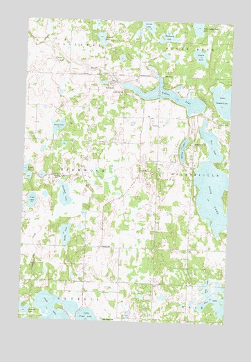
Richwood, MN USGS Topographic Map
Click on map above to begin viewing in our Map Viewer.

This topographic map contains these locations and features:
Feature Name Type Latitude Longitude GNIS ID View Map
Albert LakeReservoirN46.9383°W95.7587°1776199View Map
Albert Lake DamDamN46.9383°W95.7587°1776198View Map
Bakke Lutheran CemeteryCemeteryN46.9052°W95.8274°2108275View Map
Bakke Lutheran ChurchChurchN46.9058°W95.8264°2108614View Map
Bakke SchoolSchoolN46.9058°W95.8264°639589View Map
Blackberry LakeLakeN46.9934°W95.7897°640231View Map
Buffalo LakeReservoirN46.9689°W95.7874°640613View Map
Buffalo LakeReservoirN46.9733°W95.8170°1776108View Map
Buffalo Lake CampgroundLocaleN46.9617°W95.7736°2108743View Map
Buffalo Lake CemeteryCemeteryN46.9708°W95.8164°640617View Map
Buffalo Lake DamDamN46.9733°W95.8170°1776107View Map
Campbell CreekStreamN46.8841°W95.8645°640847View Map
Campbell LakeLakeN46.9263°W95.8493°640853View Map
Detroit Lakes City ParkParkN46.9728°W95.8417°2108315View Map
Eagen LakeLakeN46.9859°W95.7698°643005View Map
Fish LakeLakeN46.9245°W95.8694°643690View Map
Five LakeLakeN46.8845°W95.7585°639164View Map
Holmesville ChurchChurchN46.9491°W95.7717°645104View Map
Holmesville Township CemeteryCemeteryN46.9490°W95.7714°2108247View Map
Houg LakeLakeN46.9555°W95.8547°645248View Map
Little Floyd LakeReservoirN46.9150°W95.7737°1776112View Map
Little Floyd Lake DamDamN46.9150°W95.7737°1776111View Map
Little Floyd SchoolSchoolN46.8761°W95.8253°646806View Map
Loon LakeLakeN46.8902°W95.7620°647171View Map
Lund CemeteryCemeteryN46.9383°W95.8042°2108276View Map
Lund ChurchChurchN46.9377°W95.8045°647291View Map
Northern Lights Tabernacle ChurchChurchN46.9747°W95.8225°2108742View Map
Pelican Valley SchoolSchoolN46.9347°W95.8562°649249View Map
Rice LakeLakeN46.9500°W95.7616°650016View Map
RichwoodPopulated PlaceN46.9747°W95.8228°650071View Map
Richwood Post Office (historical)Post OfficeN46.9747°W95.8225°2108741View Map
Rock LakeLakeN46.9266°W95.7559°650201View Map
Sands LakeLakeN46.9107°W95.8482°651179View Map
School Number 87SchoolN46.9583°W95.7509°651760View Map
Somdahl LakeLakeN46.9925°W95.8299°652250View Map
Spring LakeLakeN46.9454°W95.7780°652470View Map
Tamarac LakeLakeN46.8794°W95.8726°660018View Map
Tovson LakeLakeN46.9371°W95.8745°660020View Map
Township of RichwoodCivilN46.9342°W95.8580°665419View Map

Note: Coordinates in the location and feature list above are referenced to NAD83 datum.


Copyright (C) 2008-2025 Ryan Niemi / Sunset Dynamics ... All Rights Reserved