TopoQuest Logo
Do you find TopoQuest useful?
Help keep TopoQuest running and adding new maps/features by donating!
Bitcoin:  19c7KJd3qBynnjoSw5npx9KScwjBe4ifkT
Litecoin:  LXs6TkuXGGXo1vDsWCkWVdjQX94eUKd6ui
Home View Maps Find Maps Find Places Resources & Links


Ridgeland, South Carolina Topographic Map

USGS Map Title: Ridgeland, SC
USGS Map MRC: 32080D8
DRG (GeoTIFF) Download: o32080d8.tif


Neighboring USGS Topographic Map Quads:


  Calfpen Bay, SC  
32081E1
 

  Coosawhatchie, SC  
32080E8
 

  Sheldon, SC  
32080E7
 

  Tillman, SC  
32081D1
 

  Ridgeland, SC  
32080D8
 

  Laurel Bay, SC  
32080D7
 

  Hardeeville, SC  
32081C1
 

  Jasper, SC  
32080C8
 

  Spring Island, SC  
32080C7


Map MRC Location:

N33°
W81°
N33°
W80°
H8 H7 H6 H5 H4 H3 H2 H1
G8 G7 G6 G5 G4 G3 G2 G1
F8 F7 F6 F5 F4 F3 F2 F1
E8 E7 E6 E5 E4 E3 E2 E1
D8 D7 D6 D5 D4 D3 D2 D1
C8 C7 C6 C5 C4 C3 C2 C1
B8 B7 B6 B5 B4 B3 B2 B1
A8 A7 A6 A5 A4 A3 A2 A1
N32°
W81°
N32°
W80°

Ridgeland, SC USGS 1:24K Topographic Map Preview:
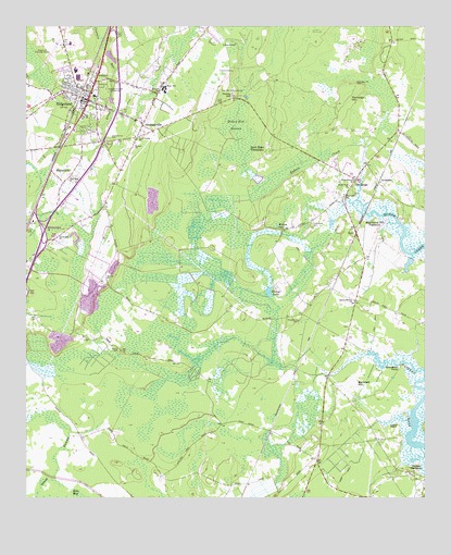
Ridgeland, SC USGS Topographic Map
Click on map above to begin viewing in our Map Viewer.

This topographic map contains these locations and features:
Feature Name Type Latitude Longitude GNIS ID View Map
Annie York ChurchChurchN32.4582°W80.8984°1220207View Map
Barnwell HillSummitN32.4055°W80.8971°1231030View Map
Berton CemeteryCemeteryN32.4141°W80.9704°1220519View Map
BoydPopulated PlaceN32.4455°W80.8962°1231075View Map
Broughton PointCapeN32.4094°W80.8826°1221000View Map
Carey Hill ChurchChurchN32.4449°W80.9898°1247161View Map
Chelsea PlantationLocaleN32.3821°W80.8782°1221533View Map
Euhaw ChurchChurchN32.4682°W80.9662°1247689View Map
Euhaw ChurchChurchN32.4832°W80.9579°1247690View Map
First Euhaw ChurchChurchN32.4596°W80.8971°1247749View Map
Good Hope Hunting Club (historical)LocaleN32.4710°W80.9229°1241349View Map
Good Hope PlantationLocaleN32.4685°W80.9246°1222753View Map
Good Hope School (historical)SchoolN32.4713°W80.8823°1241351View Map
Good Hope School (historical)SchoolN32.4591°W80.8973°1241352View Map
GrahamvillePopulated PlaceN32.4741°W80.9634°1222805View Map
Grahamville CemeteryCemeteryN32.4705°W80.9737°1222807View Map
Great SwampSwampN32.3849°W80.9907°1222854View Map
Harold Turpin ParkParkN32.4821°W80.9779°1241354View Map
Heyward ChurchChurchN32.4557°W80.9001°1245967View Map
Holy Trinity ChurchChurchN32.4705°W80.9651°1246032View Map
Honey HillSummitN32.4824°W80.9346°1231400View Map
Honey Hill SwampSwampN32.4741°W80.9343°1223265View Map
Interchange 18CrossingN32.4441°W80.9948°1242409View Map
Interchange 21CrossingN32.4777°W80.9715°1228299View Map
Jasper County CourthouseBuildingN32.4844°W80.9854°1241360View Map
Jasper County Disaster Preparedness OfficeBuildingN32.4892°W80.9857°2334943View Map
Jasper County Emergency Services DivisionBuildingN32.4951°W80.9888°2368438View Map
Jasper County Industrial ParkLocaleN32.4872°W80.9692°2489481View Map
Jasper County JailBuildingN32.4794°W80.9940°1241361View Map
Jasper County Sheriff's OfficeBuildingN32.4977°W80.9727°2334944View Map
Jasper Fire Department Station 30BuildingN32.4951°W80.9888°2368421View Map
Laurel PointCapeN32.3944°W80.8834°1223834View Map
Lovely Hill Baptist ChurchChurchN32.4765°W80.9767°2490271View Map
Low Country General HospitalHospitalN32.4955°W80.9851°1247956View Map
Mary Gorden Ellis Executive BuildingBuildingN32.4893°W80.9862°2490452View Map
MitchellvillePopulated PlaceN32.4619°W80.9921°1231551View Map
Mount Pleasant Back WaterSwampN32.4255°W80.9434°1241365View Map
NevadumPopulated PlaceN32.4588°W80.8893°1249784View Map
New Zion ChurchChurchN32.4605°W80.9862°1249857View Map
Old HousePopulated PlaceN32.4596°W80.8965°1225189View Map
Partridge HillSummitN32.4816°W80.8990°1231637View Map
Partridge Hill CemeteryCemeteryN32.4849°W80.8965°1250031View Map
Pratt Memorial LibraryBuildingN32.4816°W80.9779°1241553View Map
Preference CemeteryCemeteryN32.4469°W80.9101°1225662View Map
Richfield LakeSwampN32.4332°W80.9504°1241557View Map
Ridge Pointe SquareParkN32.4807°W80.9829°1241555View Map
RidgelandPopulated PlaceN32.4807°W80.9804°1250384View Map
Ridgeland Baptist ChurchChurchN32.4904°W80.9854°2490272View Map
Ridgeland Correctional InstitutionBuildingN32.4963°W80.9662°2735630View Map
Ridgeland DivisionCivilN32.4782°W80.9239°1938399View Map
Ridgeland Elementary SchoolSchoolN32.4837°W80.9561°1241556View Map
Ridgeland High SchoolSchoolN32.4837°W80.9562°1241362View Map
Ridgeland Junior High SchoolSchoolN32.4836°W80.9560°2486485View Map
Ridgeland Police DepartmentBuildingN32.4879°W80.9775°2334879View Map
Ridgeland Post OfficePost OfficeN32.4818°W80.9846°1252255View Map
Ridgeland Town HallBuildingN32.4810°W80.9773°1241558View Map
Rigleand-Claude Dean AirportAirportN32.4923°W80.9916°1251591View Map
Saint Paul United Methodist ChurchChurchN32.4819°W80.9852°2490273View Map
Sandy Hill School (historical)SchoolN32.3949°W80.9068°1241567View Map
Second Euhaw ChurchChurchN32.4274°W80.8968°1250825View Map
South Carolina Highway Patrol Troop 6 Post CBuildingN32.4904°W80.9854°2334926View Map
South Carolina Noname 27012 D-2591 DamDamN32.4385°W80.8782°1238750View Map
Strawberry Hill PlantationLocaleN32.4466°W80.8898°1226924View Map
Tismyr LakeLakeN32.4296°W80.9237°1227159View Map
Town of RidgelandCivilN32.4681°W80.9177°2407214View Map
Town of Ridgeland Fire DepartmentBuildingN32.4806°W80.9829°2368442View Map
WCOG-AM (Ridgeland)TowerN32.4363°W80.9229°1252405View Map
Wellington Back WaterSwampN32.4216°W80.9487°1241582View Map
Willow PondLakeN32.4473°W80.9210°1227629View Map
Wrightfield CemeteryCemeteryN32.4221°W80.9145°1227715View Map
WSHG-FM (Ridgeland)TowerN32.4363°W80.9229°1252541View Map

Note: Coordinates in the location and feature list above are referenced to NAD83 datum.


Copyright (C) 2008-2025 Ryan Niemi / Sunset Dynamics ... All Rights Reserved