TopoQuest Logo
Do you find TopoQuest useful?
Help keep TopoQuest running and adding new maps/features by donating!
Bitcoin:  19c7KJd3qBynnjoSw5npx9KScwjBe4ifkT
Litecoin:  LXs6TkuXGGXo1vDsWCkWVdjQX94eUKd6ui
Home View Maps Find Maps Find Places Resources & Links


Ridgeville, Georgia Topographic Map

USGS Map Title: Ridgeville, GA
USGS Map MRC: 31081D4
DRG (GeoTIFF) Download: o31081d4.tif


Neighboring USGS Topographic Map Quads:


  Townsend, GA  
31081E5


  Cox, GA  
31081D5
 

  Ridgeville, GA  
31081D4
 

  Doboy Sound, GA  
31081D3
 

  Sterling, GA  
31081C5
 

  Darien, GA  
31081C4
 

  Altamaha Sound, GA  
31081C3


Map MRC Location:

N32°
W82°
N32°
W81°
H8 H7 H6 H5 H4 H3 H2 H1
G8 G7 G6 G5 G4 G3 G2 G1
F8 F7 F6 F5 F4 F3 F2 F1
E8 E7 E6 E5 E4 E3 E2 E1
D8 D7 D6 D5 D4 D3 D2 D1
C8 C7 C6 C5 C4 C3 C2 C1
B8 B7 B6 B5 B4 B3 B2 B1
A8 A7 A6 A5 A4 A3 A2 A1
N31°
W82°
N31°
W81°

Ridgeville, GA USGS 1:24K Topographic Map Preview:
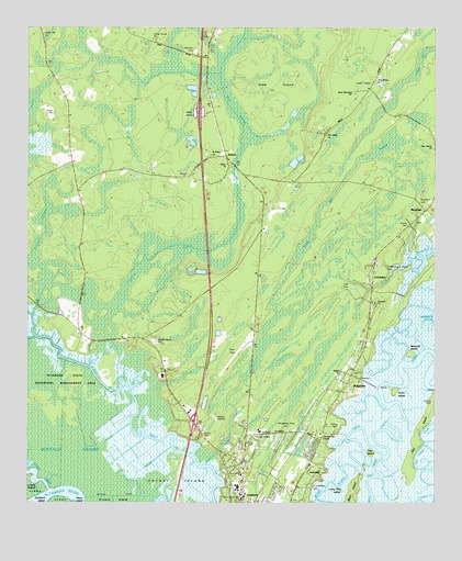
Ridgeville, GA USGS Topographic Map
Click on map above to begin viewing in our Map Viewer.

This topographic map contains these locations and features:
Feature Name Type Latitude Longitude GNIS ID View Map
ArdickPopulated PlaceN31.4613°W81.4334°326159View Map
AshintillyPopulated PlaceN31.3938°W81.4090°331056View Map
Bethel ChurchChurchN31.4099°W81.4040°311165View Map
Boggy Gall SwampSwampN31.4123°W81.4301°311617View Map
Briardam SwampSwampN31.4452°W81.4943°311771View Map
CarniganPopulated PlaceN31.4344°W81.3940°354999View Map
Chisholm SwampSwampN31.4008°W81.4607°312647View Map
Credit Hill ChurchChurchN31.4983°W81.4948°313100View Map
Cuthbert-Grant CemeteryCemeteryN31.4377°W81.3909°356849View Map
Daniel Grove ChurchChurchN31.4969°W81.4609°313283View Map
Darien HeightsPopulated PlaceN31.3755°W81.4268°356851View Map
Darien Water Pollution Control PlantLocaleN31.3976°W81.4423°2502452View Map
East Light ChurchChurchN31.4724°W81.4084°313780View Map
Ebenezer CemeteryCemeteryN31.4938°W81.4484°356857View Map
Ebenezer ChurchChurchN31.4941°W81.4482°313820View Map
Eden Field Airport (historical)AirportN31.4129°W81.4372°358214View Map
Emanuel Baptist ChurchChurchN31.4277°W81.3934°356858View Map
Exit 10CrossingN31.3963°W81.4490°1686691View Map
FairviewPopulated PlaceN31.3772°W81.4245°356860View Map
Faith Bible ChapelChurchN31.3933°W81.4098°356861View Map
First African ChurchChurchN31.4691°W81.3754°355796View Map
Georgia Islands Factory ShoppesLocaleN31.3957°W81.4517°2502079View Map
Hird IslandIslandN31.3922°W81.3801°315463View Map
Hird Island CreekGutN31.3874°W81.3807°315464View Map
Holy ChurchChurchN31.4013°W81.4312°356874View Map
Hudson CemeteryCemeteryN31.4477°W81.3832°356876View Map
Hutchinson CemeteryCemeteryN31.4544°W81.3801°356877View Map
King CemeteryCemeteryN31.4319°W81.4004°316427View Map
King SwampSwampN31.4763°W81.4362°316436View Map
Lewis CreekStreamN31.3788°W81.4929°316782View Map
McIntosh CountyCivilN31.4838°W81.3756°356886View Map
McIntosh County AcademySchoolN31.4404°W81.4311°356887View Map
McIntosh County Fire Department Northside StationBuildingN31.4007°W81.4315°2604970View Map
McIntosh County JailBuildingN31.4169°W81.4560°356889View Map
Mcintosh County Sheriff's OfficeBuildingN31.4087°W81.4563°2733708View Map
MeridianPopulated PlaceN31.4519°W81.3779°318042View Map
New Homes ChurchChurchN31.4858°W81.3937°319348View Map
Oglethorpe AcademySchoolN31.3938°W81.4284°356893View Map
Otter CreekStreamN31.4188°W81.4973°320117View Map
Pine IslandIslandN31.3880°W81.3943°320610View Map
Potosi IslandIslandN31.3816°W81.4523°321093View Map
Powell CemeteryCemeteryN31.3958°W81.4043°321110View Map
RidgevillePopulated PlaceN31.4063°W81.4015°321595View Map
Rifle CutGutN31.3769°W81.4737°321600View Map
River SwampSwampN31.3752°W81.4915°321632View Map
Robson CemeteryCemeteryN31.4777°W81.4920°321703View Map
Rockenboughs CreekStreamN31.3999°W81.3898°356899View Map
Saint Andrews CemeteryCemeteryN31.3794°W81.4129°322043View Map
Saint Marks ChurchChurchN31.4663°W81.4434°322174View Map
Sams Memorial ChurchChurchN31.4833°W81.4004°356904View Map
Todd Grant Elementary SchoolSchoolN31.3791°W81.4353°356907View Map
Tolomato Spanish Mission RuinsLocaleN31.4286°W81.3845°324212View Map
Union ChurchChurchN31.4641°W81.4384°324510View Map
Union IslandIslandN31.4038°W81.3876°324576View Map
Upper Mill CemeteryCemeteryN31.3813°W81.4359°324624View Map
Whispering Pines CemeteryCemeteryN31.3944°W81.4207°356915View Map

Note: Coordinates in the location and feature list above are referenced to NAD83 datum.


Copyright (C) 2008-2025 Ryan Niemi / Sunset Dynamics ... All Rights Reserved