TopoQuest Logo
Do you find TopoQuest useful?
Help keep TopoQuest running and adding new maps/features by donating!
Bitcoin:  19c7KJd3qBynnjoSw5npx9KScwjBe4ifkT
Litecoin:  LXs6TkuXGGXo1vDsWCkWVdjQX94eUKd6ui
Home View Maps Find Maps Find Places Resources & Links


Sterling, Georgia Topographic Map

USGS Map Title: Sterling, GA
USGS Map MRC: 31081C5
DRG (GeoTIFF) Download: o31081c5.tif


Neighboring USGS Topographic Map Quads:


  Everett, GA  
31081D6
 

  Cox, GA  
31081D5
 

  Ridgeville, GA  
31081D4
 

  Thalmann, GA  
31081C6
 

  Sterling, GA  
31081C5
 

  Darien, GA  
31081C4
 

  Bladen, GA  
31081B6
 

  Brunswick West, GA  
31081B5
 

  Brunswick East, GA  
31081B4


Map MRC Location:

N32°
W82°
N32°
W81°
H8 H7 H6 H5 H4 H3 H2 H1
G8 G7 G6 G5 G4 G3 G2 G1
F8 F7 F6 F5 F4 F3 F2 F1
E8 E7 E6 E5 E4 E3 E2 E1
D8 D7 D6 D5 D4 D3 D2 D1
C8 C7 C6 C5 C4 C3 C2 C1
B8 B7 B6 B5 B4 B3 B2 B1
A8 A7 A6 A5 A4 A3 A2 A1
N31°
W82°
N31°
W81°

Sterling, GA USGS 1:24K Topographic Map Preview:
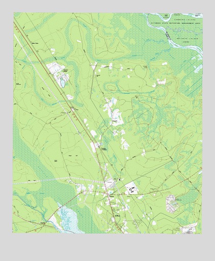
Sterling, GA USGS Topographic Map
Click on map above to begin viewing in our Map Viewer.

This topographic map contains these locations and features:
Feature Name Type Latitude Longitude GNIS ID View Map
Altamaha Wildlife Management AreaParkN31.3688°W81.5132°354296View Map
AnguillaPopulated PlaceN31.2555°W81.6034°331045View Map
Berry LakeLakeN31.3351°W81.5920°311116View Map
Boggy GallFlatN31.2947°W81.5818°311616View Map
BrobstonPopulated PlaceN31.2602°W81.5579°311816View Map
Buffalo SwampSwampN31.2942°W81.6194°311998View Map
Buffalo SwampSwampN31.2501°W81.5727°325762View Map
Camp SquawcheeLocaleN31.2694°W81.5179°312260View Map
Church of God of ProphecyChurchN31.2749°W81.5768°1671474View Map
Clayhole SwampSwampN31.3633°W81.5390°355182View Map
Coastal Pines Golf ClubLocaleN31.2804°W81.5194°2502594View Map
Coneys TempleChurchN31.3258°W81.5632°312890View Map
Cottonbox IslandIslandN31.3749°W81.5076°313009View Map
Cowpen CreekStreamN31.3594°W81.5223°313067View Map
Cowpen SwampSwampN31.3508°W81.5893°355360View Map
Daniel CemeteryCemeteryN31.2508°W81.5478°1671482View Map
Everett DivisionCivilN31.2970°W81.5173°1936256View Map
Frazers CrossingPopulated PlaceN31.2988°W81.5673°355910View Map
Georgia Forestry CommissionBuildingN31.2568°W81.6101°2604693View Map
Glynn County Fire Department Station 3BuildingN31.2684°W81.5594°2603631View Map
Good Shepherd ChurchChurchN31.3208°W81.5595°314688View Map
Green SwampSwampN31.2947°W81.5615°314859View Map
Groveside ParkPopulated PlaceN31.2697°W81.5204°1671525View Map
Halfway CreekStreamN31.3524°W81.5273°315026View Map
Haven ChapelChurchN31.2811°W81.5643°315232View Map
Hells GateLocaleN31.2805°W81.6118°315306View Map
Honeygall CreekStreamN31.3561°W81.5193°315616View Map
Honeygall LandingLocaleN31.3441°W81.5357°332017View Map
Honeygall SwampSwampN31.3433°W81.5345°315617View Map
Houston BranchStreamN31.3458°W81.6159°315739View Map
Hunters SidingLocaleN31.3369°W81.5965°315833View Map
Jerusalem ChurchChurchN31.3244°W81.5618°316092View Map
Jerusalem Missionary Baptist ChurchChurchN31.3000°W81.5651°2502762View Map
Little Buffalo SwampStreamN31.2736°W81.5990°316976View Map
Live Oak Mobile Home VillagePopulated PlaceN31.2501°W81.5241°2502521View Map
Liz HillSummitN31.3283°W81.5434°332250View Map
Mill BranchStreamN31.2936°W81.6226°318174View Map
Minnow CreekChannelN31.3644°W81.5057°318319View Map
Oak Head DrainStreamN31.2924°W81.6071°319821View Map
Pennant HillSummitN31.3388°W81.5704°332635View Map
PennickPopulated PlaceN31.3130°W81.5590°332636View Map
Pine HavenPopulated PlaceN31.2530°W81.5162°1671573View Map
Pine Haven ChurchChurchN31.2522°W81.5134°1671571View Map
Rough IslandIslandN31.3297°W81.6034°321953View Map
Saint Johns ChurchChurchN31.3458°W81.5726°322110View Map
Salem ChurchChurchN31.2844°W81.5623°322342View Map
Scrub IslandIslandN31.2897°W81.5965°322665View Map
South Branch South Altamaha RiverChannelN31.3561°W81.5148°323234View Map
Southern Pines Mobile Home VillagePopulated PlaceN31.2740°W81.5332°2502543View Map
SterlingPopulated PlaceN31.2724°W81.5615°323583View Map
Sterling ChurchChurchN31.2544°W81.5545°323584View Map
Sterling Elementary SchoolSchoolN31.2652°W81.5624°2453161View Map
Sterling ParkParkN31.2669°W81.5643°1671594View Map
Tabby CreekStreamN31.3547°W81.5057°323868View Map
The Church of Jesus Christ of Latter Day SaintsChurchN31.2591°W81.5033°2502742View Map
Union Industrial School (historical)SchoolN31.2686°W81.5607°334677View Map
Wrights IslandIslandN31.3597°W81.5040°325583View Map
WXMK-FM (Dock Junction)TowerN31.2824°W81.5540°352673View Map
ZutaPopulated PlaceN31.3208°W81.5840°326606View Map
Zuta BranchSwampN31.3258°W81.6054°325725View Map

Note: Coordinates in the location and feature list above are referenced to NAD83 datum.


Copyright (C) 2008-2025 Ryan Niemi / Sunset Dynamics ... All Rights Reserved