TopoQuest Logo
Do you find TopoQuest useful?
Help keep TopoQuest running and adding new maps/features by donating!
Bitcoin:  19c7KJd3qBynnjoSw5npx9KScwjBe4ifkT
Litecoin:  LXs6TkuXGGXo1vDsWCkWVdjQX94eUKd6ui
Home View Maps Find Maps Find Places Resources & Links


Big Park, Wyoming Topographic Map

USGS Map Title: Big Park, WY
USGS Map MRC: 42110C7
DRG (GeoTIFF) Download: o42110c7.tif


Neighboring USGS Topographic Map Quads:


  Salt Flat, WY  
42110D8
 

  Porcupine Creek, WY  
42110D7
 

  Graham Peak, WY  
42110D6
 

  Huff Lake, WY  
42110C8
 

  Big Park, WY  
42110C7
 

  Devils Hole Creek, WY  
42110C6
 

  Marse, WY  
42110B8
 

  Nugent Park, WY  
42110B7
 

  Pole Creek, WY  
42110B6


Map MRC Location:

N43°
W111°
N43°
W110°
H8 H7 H6 H5 H4 H3 H2 H1
G8 G7 G6 G5 G4 G3 G2 G1
F8 F7 F6 F5 F4 F3 F2 F1
E8 E7 E6 E5 E4 E3 E2 E1
D8 D7 D6 D5 D4 D3 D2 D1
C8 C7 C6 C5 C4 C3 C2 C1
B8 B7 B6 B5 B4 B3 B2 B1
A8 A7 A6 A5 A4 A3 A2 A1
N42°
W111°
N42°
W110°

Big Park, WY USGS 1:24K Topographic Map Preview:
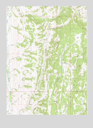
Big Park, WY USGS Topographic Map
Click on map above to begin viewing in our Map Viewer.

This topographic map contains these locations and features:
Feature Name Type Latitude Longitude GNIS ID View Map
Big ParkFlatN42.3385°W110.7641°1598161View Map
Big Park ProspectMineN42.3386°W110.7750°1746402View Map
Bird CreekStreamN42.2872°W110.7768°1598192View Map
Bloom HollowValleyN42.2977°W110.8724°1598255View Map
Button FlatFlatN42.2527°W110.8702°1598543View Map
Cliff CreekStreamN42.3610°W110.8202°1598801View Map
Coantag CreekStreamN42.3694°W110.7877°1597661View Map
Dry Fork Smiths ForkStreamN42.3633°W110.8716°1599356View Map
Ferney GulchValleyN42.3491°W110.8068°1599691View Map
Ferney Gulch Prospects MineMineN42.3497°W110.7918°1746403View Map
Green KnollSummitN42.3058°W110.7596°1600071View Map
Grindstone CreekStreamN42.3027°W110.7741°1600099View Map
Hock CreekStreamN42.2874°W110.7768°1600353View Map
Japanese ParkFlatN42.2960°W110.7916°1600591View Map
Kelley Guard StationLocaleN42.2647°W110.7991°1600686View Map
Little ParkFlatN42.3269°W110.7838°1601014View Map
Little Park CreekStreamN42.3097°W110.7871°1601015View Map
Middle RidgeRidgeN42.2949°W110.7541°1604340View Map
Preacher HollowValleyN42.3083°W110.8735°1602305View Map
Sams CreekStreamN42.3605°W110.8116°1602703View Map
Smith Fork CemeteryCemeteryN42.2553°W110.8674°2774429View Map
Squirrel CreekStreamN42.2924°W110.7752°1603318View Map
Tuffield CreekStreamN42.2788°W110.8685°1603790View Map
Twiss HollowValleyN42.2624°W110.8668°1603838View Map

Note: Coordinates in the location and feature list above are referenced to NAD83 datum.


Copyright (C) 2008-2024 Ryan Niemi / Sunset Dynamics ... All Rights Reserved