TopoQuest Logo
Do you find TopoQuest useful?
Help keep TopoQuest running and adding new maps/features by donating!
Bitcoin:  19c7KJd3qBynnjoSw5npx9KScwjBe4ifkT
Litecoin:  LXs6TkuXGGXo1vDsWCkWVdjQX94eUKd6ui
Home View Maps Find Maps Find Places Resources & Links


Rio Grande, New Jersey Topographic Map

USGS Map Title: Rio Grande, NJ
USGS Map MRC: 39074A8
DRG (GeoTIFF) Download: o39074a8.tif


Neighboring USGS Topographic Map Quads:


  Port Norris, NJ  
39075B1
 

  Heislerville, NJ  
39074B8
 

  Woodbine, NJ  
39074B7


  Rio Grande, NJ  
39074A8
 

  Stone Harbor, NJ  
39074A7


  Cape May, NJ  
38074H8
 

  Wildwood, NJ  
38074H7


Map MRC Location:

N40°
W75°
N40°
W74°
H8 H7 H6 H5 H4 H3 H2 H1
G8 G7 G6 G5 G4 G3 G2 G1
F8 F7 F6 F5 F4 F3 F2 F1
E8 E7 E6 E5 E4 E3 E2 E1
D8 D7 D6 D5 D4 D3 D2 D1
C8 C7 C6 C5 C4 C3 C2 C1
B8 B7 B6 B5 B4 B3 B2 B1
A8 A7 A6 A5 A4 A3 A2 A1
N39°
W75°
N39°
W74°

Rio Grande, NJ USGS 1:24K Topographic Map Preview:
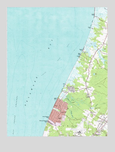
Rio Grande, NJ USGS Topographic Map
Click on map above to begin viewing in our Map Viewer.

This topographic map contains these locations and features:
Feature Name Type Latitude Longitude GNIS ID View Map
Bowman ManorPopulated PlaceN39.0162°W74.9341°874874View Map
Cape May County AirportAirportN39.0057°W74.9139°884982View Map
Cooks BeachBeachN39.1090°W74.8941°874195View Map
Del HavenPopulated PlaceN39.0468°W74.9196°875867View Map
Dias CreekPopulated PlaceN39.0890°W74.8804°875911View Map
Dias CreekStreamN39.0920°W74.9002°875912View Map
Erma ParkPopulated PlaceN39.0059°W74.8835°876209View Map
Erma Volunteer Fire CompanyBuildingN39.0013°W74.9087°2401621View Map
Fishing CreekPopulated PlaceN39.0229°W74.9338°876353View Map
Fishing CreekStreamN39.0391°W74.9357°876358View Map
Fishing Creek SchoolSchoolN39.0143°W74.9385°876360View Map
Fishing Creek ShoalBarN39.0776°W74.9327°876361View Map
Fulling Mill StreamStreamN39.0337°W74.9216°876537View Map
Green CreekPopulated PlaceN39.0462°W74.9013°876776View Map
Green CreekStreamN39.0637°W74.9187°876777View Map
Green Creek Post OfficePost OfficeN39.0459°W74.9015°2781431View Map
Green Creek Volunteer Fire Company 3BuildingN39.0468°W74.9034°2401840View Map
Hickory IslandIslandN39.0321°W74.9177°877080View Map
Highs BeachPopulated PlaceN39.0793°W74.9085°877110View Map
Kay PondLakeN39.0603°W74.8915°877522View Map
Kimbles BeachBeachN39.1057°W74.8957°882663View Map
Kimbles BeachPopulated PlaceN39.1046°W74.8938°877564View Map
KimseytownPopulated PlaceN39.0012°W74.9346°877566View Map
King Crab LandingPopulated PlaceN39.0771°W74.9102°877569View Map
Lower Township Bureau of Fire SafetyBuildingN39.0038°W74.9115°2401832View Map
Lower Township Police DepartmentBuildingN39.0043°W74.9107°2731056View Map
Lower Township Rescue SquadBuildingN39.0222°W74.9360°2401667View Map
Lower Township Rescue SquadBuildingN39.0040°W74.9114°2660157View Map
Marcy Landing (historical)LocaleN39.0383°W74.9367°2628131View Map
Memorial Elementary SchoolSchoolN39.0093°W74.9374°2333250View Map
Miami BeachPopulated PlaceN39.0346°W74.9368°878281View Map
Miami BeachBeachN39.0307°W74.9399°882672View Map
Naval Air Station Wildwood (historical)MilitaryN39.0086°W74.9089°2649169View Map
Norburys LandingPopulated PlaceN39.0504°W74.9277°878815View Map
North Highlands BeachPopulated PlaceN39.0151°W74.9443°878855View Map
NummytownPopulated PlaceN39.0251°W74.8963°882679View Map
Paramount Air AirportAirportN39.0645°W74.9074°884765View Map
Pennsylvania PondsLakeN39.0734°W74.8795°879221View Map
PiercesPopulated PlaceN39.0654°W74.8982°879278View Map
Pierces PointPopulated PlaceN39.0840°W74.9054°879279View Map
Pierces Point PondLakeN39.0815°W74.9049°879280View Map
Potato IslandSummitN39.0840°W74.8782°879459View Map
Pumping Station PondReservoirN39.0276°W74.8937°879552View Map
Reeds BeachPopulated PlaceN39.1171°W74.8910°879649View Map
Rio Grand Volunteer Fire Station 72BuildingN39.0156°W74.8776°2401835View Map
Rio GrandePopulated PlaceN39.0146°W74.8816°879703View Map
Rio Grande Census Designated PlaceCensusN39.0196°W74.8763°2389752View Map
Rio Grande Post OfficePost OfficeN39.0166°W74.8827°2781485View Map
Saint Raymond Regional Elementary SchoolSchoolN39.0321°W74.9340°2333299View Map
Sally Marshall CrossingPopulated PlaceN39.0015°W74.8918°880239View Map
Sunray BeachBeachN39.0440°W74.9318°881004View Map
VillasPopulated PlaceN39.0287°W74.9385°881460View Map
Villas Census Designated PlaceCensusN39.0157°W74.9350°2390438View Map
Villas Volunteer Fire CompanyBuildingN39.0212°W74.9349°2401833View Map
Wildwood Highlands BeachPopulated PlaceN39.0132°W74.9463°881834View Map
Wuerkers New Acres Farm HeliportAirportN39.0090°W74.8879°884915View Map

Note: Coordinates in the location and feature list above are referenced to NAD83 datum.


Copyright (C) 2008-2025 Ryan Niemi / Sunset Dynamics ... All Rights Reserved