TopoQuest Logo
Do you find TopoQuest useful?
Help keep TopoQuest running and adding new maps/features by donating!
Bitcoin:  19c7KJd3qBynnjoSw5npx9KScwjBe4ifkT
Litecoin:  LXs6TkuXGGXo1vDsWCkWVdjQX94eUKd6ui
Home View Maps Find Maps Find Places Resources & Links


Heislerville, New Jersey Topographic Map

USGS Map Title: Heislerville, NJ
USGS Map MRC: 39074B8
DRG (GeoTIFF) Download: o39074b8.tif


Neighboring USGS Topographic Map Quads:


  Dividing Creek, NJ  
39075C1
 

  Port Elizabeth, NJ  
39074C8
 

  Tuckahoe, NJ  
39074C7
 

  Port Norris, NJ  
39075B1
 

  Heislerville, NJ  
39074B8
 

  Woodbine, NJ  
39074B7


  Rio Grande, NJ  
39074A8
 

  Stone Harbor, NJ  
39074A7


Map MRC Location:

N40°
W75°
N40°
W74°
H8 H7 H6 H5 H4 H3 H2 H1
G8 G7 G6 G5 G4 G3 G2 G1
F8 F7 F6 F5 F4 F3 F2 F1
E8 E7 E6 E5 E4 E3 E2 E1
D8 D7 D6 D5 D4 D3 D2 D1
C8 C7 C6 C5 C4 C3 C2 C1
B8 B7 B6 B5 B4 B3 B2 B1
A8 A7 A6 A5 A4 A3 A2 A1
N39°
W75°
N39°
W74°

Heislerville, NJ USGS 1:24K Topographic Map Preview:
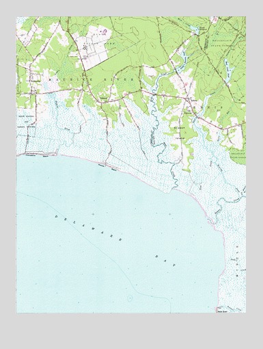
Heislerville, NJ USGS Topographic Map
Click on map above to begin viewing in our Map Viewer.

This topographic map contains these locations and features:
Feature Name Type Latitude Longitude GNIS ID View Map
Bayside State PrisonBuildingN39.2439°W74.9514°2733230View Map
Bidwell CreekStreamN39.1276°W74.8903°874740View Map
Bills GutGutN39.1265°W74.8832°882625View Map
DelmontPopulated PlaceN39.2143°W74.9499°875885View Map
Delmont Post OfficePost OfficeN39.2144°W74.9511°2401572View Map
Dennis CreekStreamN39.1663°W74.8911°875893View Map
East CreekStreamN39.1733°W74.8998°876046View Map
East Creek PondReservoirN39.2277°W74.8844°876048View Map
East Creek Pond DamDamN39.2223°W74.8863°884026View Map
EldoraPopulated PlaceN39.2154°W74.9060°876138View Map
Eldora SchoolSchoolN39.2098°W74.9035°876139View Map
Goshen CreekStreamN39.1474°W74.8853°876686View Map
Hands Mill PondReservoirN39.2450°W74.9035°876926View Map
Hands Mill Pond DamDamN39.2429°W74.9016°884025View Map
HeislervillePopulated PlaceN39.2232°W74.9924°877035View Map
Heislerville Volunteer Fire CompanyBuildingN39.2291°W74.9919°2401761View Map
Moores BeachBeachN39.1885°W74.9498°878465View Map
New Jersey State Prison FarmBuildingN39.2404°W74.9524°874205View Map
Old Robins BranchStreamN39.1747°W74.8766°878964View Map
Pickle Factory PondReservoirN39.2277°W74.9108°879275View Map
Riggin DitchCanalN39.1921°W74.9771°879692View Map
Roaring DitchStreamN39.1736°W74.8785°879730View Map
Savages RunStreamN39.2331°W74.8852°880270View Map
Southern State Correctional FacilityBuildingN39.2351°W74.9550°2733224View Map
Stipson IslandIslandN39.2007°W74.9102°880907View Map
Thompsons BeachBeachN39.1923°W74.9924°881161View Map
Victory Lakes Dam Number OneDamN39.1340°W74.9505°884361View Map
West CreekStreamN39.1787°W74.9123°881695View Map
Wilsons RunStreamN39.1926°W74.8929°881850View Map

Note: Coordinates in the location and feature list above are referenced to NAD83 datum.


Copyright (C) 2008-2025 Ryan Niemi / Sunset Dynamics ... All Rights Reserved