TopoQuest Logo
Do you find TopoQuest useful?
Help keep TopoQuest running and adding new maps/features by donating!
Bitcoin:  19c7KJd3qBynnjoSw5npx9KScwjBe4ifkT
Litecoin:  LXs6TkuXGGXo1vDsWCkWVdjQX94eUKd6ui
Home View Maps Find Maps Find Places Resources & Links


Port Norris, New Jersey Topographic Map

USGS Map Title: Port Norris, NJ
USGS Map MRC: 39075B1
DRG (GeoTIFF) Download: o39075b1.tif


Neighboring USGS Topographic Map Quads:


  Cedarville, NJ  
39075C2
 

  Dividing Creek, NJ  
39075C1
 

  Port Elizabeth, NJ  
39074C8
 

  Fortescue, NJ  
39075B2
 

  Port Norris, NJ  
39075B1
 

  Heislerville, NJ  
39074B8


  Rio Grande, NJ  
39074A8


Map MRC Location:

N40°
W76°
N40°
W75°
H8 H7 H6 H5 H4 H3 H2 H1
G8 G7 G6 G5 G4 G3 G2 G1
F8 F7 F6 F5 F4 F3 F2 F1
E8 E7 E6 E5 E4 E3 E2 E1
D8 D7 D6 D5 D4 D3 D2 D1
C8 C7 C6 C5 C4 C3 C2 C1
B8 B7 B6 B5 B4 B3 B2 B1
A8 A7 A6 A5 A4 A3 A2 A1
N39°
W76°
N39°
W75°

Port Norris, NJ USGS 1:24K Topographic Map Preview:
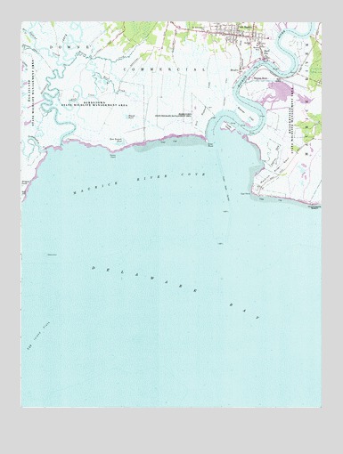
Port Norris, NJ USGS Topographic Map
Click on map above to begin viewing in our Map Viewer.

This topographic map contains these locations and features:
Feature Name Type Latitude Longitude GNIS ID View Map
Andrews DitchCanalN39.2073°W75.0177°874348View Map
Basket FlatFlatN39.2201°W75.0305°874529View Map
Bay PondsLakeN39.1937°W75.1249°874549View Map
BivalvePopulated PlaceN39.2343°W75.0338°874780View Map
Bowkers RunStreamN39.2476°W75.0169°874870View Map
Brown SchoolSchoolN39.2418°W75.0252°874978View Map
Dickeys DitchStreamN39.2334°W75.0461°875914View Map
Dividing CreekStreamN39.2140°W75.1051°875927View Map
East Branch PondLakeN39.2109°W75.0818°876041View Map
East PointCapeN39.1948°W75.0288°876062View Map
Elder PointCapeN39.2112°W75.0468°876137View Map
Fowler IslandIslandN39.2157°W75.0388°876445View Map
Hansey CreekStreamN39.2381°W75.1021°876939View Map
Heislerville Fish and Wildlife Management AreaParkN39.2126°W75.0080°883038View Map
Indian CreekGutN39.2254°W75.0957°877324View Map
Island DitchGutN39.2359°W75.1232°877371View Map
Kenny PointCapeN39.2071°W75.0871°877543View Map
Matts LandingLocaleN39.2326°W75.0146°873766View Map
Maurice RiverPopulated PlaceN39.2318°W75.0288°878196View Map
Maurice RiverStreamN39.2137°W75.0441°878197View Map
Maurice River CoveBayN39.1965°W75.0752°878198View Map
Maurice River NeckCapeN39.2012°W75.0199°878199View Map
New England CreekStreamN39.2155°W75.0511°878734View Map
Ogdens CreekStreamN39.2361°W75.1083°878946View Map
Oranoaken CreekStreamN39.2083°W75.1197°879004View Map
Port NorrisPopulated PlaceN39.2459°W75.0352°879443View Map
Port Norris Fire Company 1BuildingN39.2468°W75.0303°2401899View Map
Port Norris Middle SchoolSchoolN39.2474°W75.0344°2333436View Map
Round PondLakeN39.2196°W75.0805°879836View Map
Saint Anthonys ChurchChurchN39.2471°W75.0491°879929View Map
Shell PilePopulated PlaceN39.2404°W75.0243°880534View Map
Shiloh ChurchChurchN39.2434°W75.0291°880554View Map
Ware CreekStreamN39.2134°W75.0836°881531View Map
Wave CreekGutN39.2282°W75.0832°881628View Map
Wesley ChurchChurchN39.2432°W75.0266°881669View Map

Note: Coordinates in the location and feature list above are referenced to NAD83 datum.


Copyright (C) 2008-2025 Ryan Niemi / Sunset Dynamics ... All Rights Reserved