TopoQuest Logo
Do you find TopoQuest useful?
Help keep TopoQuest running and adding new maps/features by donating!
Bitcoin:  19c7KJd3qBynnjoSw5npx9KScwjBe4ifkT
Litecoin:  LXs6TkuXGGXo1vDsWCkWVdjQX94eUKd6ui
Home View Maps Find Maps Find Places Resources & Links


Big Point, Mississippi Topographic Map

USGS Map Title: Big Point, MS
USGS Map MRC: 30088E4
DRG (GeoTIFF) Download: o30088e4.tif


Neighboring USGS Topographic Map Quads:


  Harleston, MS  
30088F5
 

  Hurley, MS  
30088F4
 

  Tanner Williams, AL  
30088F3
 

  Three Rivers, MS  
30088E5
 

  Big Point, MS  
30088E4
 

  Saint Elmo, AL  
30088E3
 

  Pascagoula North, MS  
30088D5
 

  Kreole, MS  
30088D4
 

  Grand Bay, AL  
30088D3


Map MRC Location:

N31°
W89°
N31°
W88°
H8 H7 H6 H5 H4 H3 H2 H1
G8 G7 G6 G5 G4 G3 G2 G1
F8 F7 F6 F5 F4 F3 F2 F1
E8 E7 E6 E5 E4 E3 E2 E1
D8 D7 D6 D5 D4 D3 D2 D1
C8 C7 C6 C5 C4 C3 C2 C1
B8 B7 B6 B5 B4 B3 B2 B1
A8 A7 A6 A5 A4 A3 A2 A1
N30°
W89°
N30°
W88°

Big Point, MS USGS 1:24K Topographic Map Preview:
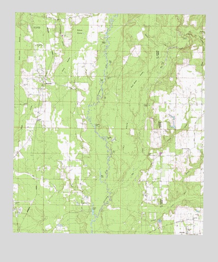
Big Point, MS USGS Topographic Map
Click on map above to begin viewing in our Map Viewer.

This topographic map contains these locations and features:
Feature Name Type Latitude Longitude GNIS ID View Map
Bay BranchStreamN30.5219°W88.3886°113583View Map
Big CreekStreamN30.5227°W88.4347°114268View Map
Big PointPopulated PlaceN30.5869°W88.4820°667134View Map
Big Point CemeteryCemeteryN30.5844°W88.4947°688910View Map
Big Point Census Designated PlaceCensusN30.5906°W88.4846°2402689View Map
Big Point Methodist ChurchChurchN30.5863°W88.4831°710401View Map
Bird LakeLakeN30.5326°W88.4427°667179View Map
Church of GodChurchN30.5095°W88.3816°143383View Map
CloverdalePopulated PlaceN30.5016°W88.3889°143251View Map
Collins CreekStreamN30.5494°W88.4145°116444View Map
Collins LakeLakeN30.5454°W88.4122°688939View Map
Cowards BluffCliffN30.5891°W88.4395°688942View Map
Crandall SchoolSchoolN30.5455°W88.3842°116812View Map
Cunningham BranchStreamN30.5783°W88.4536°669019View Map
East Central County Golf CourseLocaleN30.6063°W88.4833°688953View Map
East Central County ParkParkN30.6169°W88.4889°688954View Map
East Central Volunteer Fire Department Station 3BuildingN30.5855°W88.4806°2667827View Map
East Central Volunteer Fire Department Station 4BuildingN30.5249°W88.4712°2667681View Map
Evergreen CemeteryCemeteryN30.5169°W88.4992°688963View Map
Fiddlers SailLakeN30.5556°W88.4395°670444View Map
Forts Lake Assembly of God ChurchChurchN30.5220°W88.4121°2596756View Map
Forts Lake CemeteryCemeteryN30.5307°W88.4083°688991View Map
Forts Lake ChurchChurchN30.5308°W88.4086°670112View Map
Galloway LandingLocaleN30.6107°W88.3911°156390View Map
Goatpen LakeLakeN30.5613°W88.4467°689007View Map
Hamilton CemeteryCemeteryN30.5110°W88.3781°119630View Map
Holy Church of GodChurchN30.5485°W88.3847°143430View Map
Island BranchStreamN30.6130°W88.3825°120713View Map
Island SwampSwampN30.5958°W88.4686°671738View Map
Lily Orchard ChurchChurchN30.5163°W88.4542°689246View Map
Long LakeLakeN30.5854°W88.4436°672828View Map
Lyons CreekStreamN30.5219°W88.4478°672977View Map
Lyons LakeLakeN30.5132°W88.4474°672978View Map
Miles BluffCliffN30.5466°W88.4367°673568View Map
Miller CreekStreamN30.6130°W88.3828°122829View Map
Mule IslandIslandN30.5980°W88.4014°123580View Map
Nut BankLocaleN30.5358°W88.4861°674992View Map
Pathyway Baptist ChurchChurchN30.5556°W88.4570°2596215View Map
Petes LakeLakeN30.5967°W88.4376°675661View Map
Quail Ridge Park Mobile Home ParkPopulated PlaceN30.5278°W88.3961°2579823View Map
Red Oak SwampSwampN30.6028°W88.4628°676552View Map
Reed Brake SwampSwampN30.5885°W88.4194°676560View Map
Rubenhouse BluffCliffN30.5196°W88.4358°689131View Map
Sapling PondLakeN30.6088°W88.4401°677407View Map
Sikes BluffCliffN30.5769°W88.4425°668898View Map
Simmons BranchStreamN30.6132°W88.3775°126865View Map
Slaughter Flat LandingPopulated PlaceN30.5721°W88.4170°691998View Map
Spring BranchStreamN30.6057°W88.3992°127210View Map
Tates CemeteryCemeteryN30.5749°W88.4020°143855View Map
Temple Baptist ChurchChurchN30.5644°W88.4842°689187View Map
The NeckFlatN30.5585°W88.4264°689189View Map
Whispering Pines Golf CourseLocaleN30.6079°W88.4841°2597157View Map
Willow LakeReservoirN30.5018°W88.3853°143936View Map

Note: Coordinates in the location and feature list above are referenced to NAD83 datum.


Copyright (C) 2008-2025 Ryan Niemi / Sunset Dynamics ... All Rights Reserved