TopoQuest Logo
Do you find TopoQuest useful?
Help keep TopoQuest running and adding new maps/features by donating!
Bitcoin:  19c7KJd3qBynnjoSw5npx9KScwjBe4ifkT
Litecoin:  LXs6TkuXGGXo1vDsWCkWVdjQX94eUKd6ui
Home View Maps Find Maps Find Places Resources & Links


River Hill, Texas Topographic Map

USGS Map Title: River Hill, TX
USGS Map MRC: 32094B2
DRG (GeoTIFF) Download: o32094b2.tif


Neighboring USGS Topographic Map Quads:


  Grand Bluff, TX  
32094C3
 

  De Berry, TX  
32094C2
 

  Panola, LA  
32094C1
 

  Carthage, TX  
32094B3
 

  River Hill, TX  
32094B2
 

  Old Panola, TX  
32094B1
 

  Gary, TX  
32094A3
 

  Old Center, TX  
32094A2
 

  Galloway, TX  
32094A1


Map MRC Location:

N33°
W95°
N33°
W94°
H8 H7 H6 H5 H4 H3 H2 H1
G8 G7 G6 G5 G4 G3 G2 G1
F8 F7 F6 F5 F4 F3 F2 F1
E8 E7 E6 E5 E4 E3 E2 E1
D8 D7 D6 D5 D4 D3 D2 D1
C8 C7 C6 C5 C4 C3 C2 C1
B8 B7 B6 B5 B4 B3 B2 B1
A8 A7 A6 A5 A4 A3 A2 A1
N32°
W95°
N32°
W94°

River Hill, TX USGS 1:24K Topographic Map Preview:
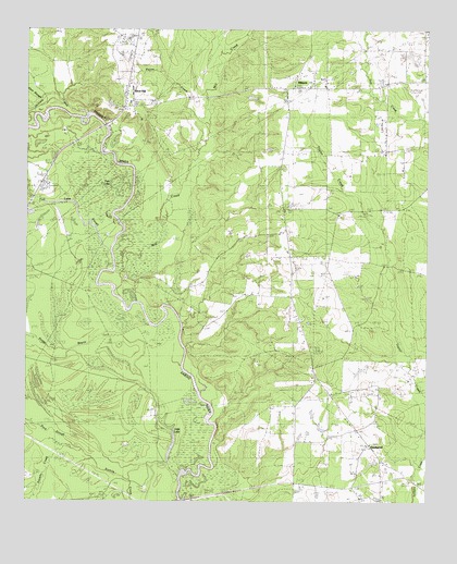
River Hill, TX USGS Topographic Map
Click on map above to begin viewing in our Map Viewer.

This topographic map contains these locations and features:
Feature Name Type Latitude Longitude GNIS ID View Map
Alexander LakeReservoirN32.1604°W94.1449°1854866View Map
Alexander Lake DamDamN32.1618°W94.1419°1854865View Map
Bethlehem ChurchChurchN32.1899°W94.1699°1351975View Map
Carthage Gas FieldOilfieldN32.1296°W94.1971°1353901View Map
Dark SloughStreamN32.1438°W94.2438°1355654View Map
De Berry-Deadwood DivisionCivilN32.2164°W94.1492°1938672View Map
DeadwoodPopulated PlaceN32.1399°W94.1419°1379642View Map
Deadwood ChurchChurchN32.1463°W94.1396°1355780View Map
East Side SchoolSchoolN32.2349°W94.1569°1356705View Map
Fish LakeLakeN32.2082°W94.2232°1357356View Map
Fish Lake SloughStreamN32.1871°W94.2246°1373723View Map
Flatwoods Volunteer Fire DepartmentBuildingN32.1419°W94.1443°2655188View Map
Gum SloughStreamN32.2321°W94.2452°1373950View Map
Hickey Lake DamDamN32.2435°W94.1285°1854864View Map
Hill LakeLakeN32.1400°W94.2045°1359247View Map
Hog BayouStreamN32.1366°W94.2280°1359340View Map
Hoggs BayouStreamN32.1724°W94.2102°1359384View Map
Jackson CreekStreamN32.2282°W94.2316°1374260View Map
MidyettPopulated PlaceN32.2352°W94.1677°2034795View Map
Mill CreekStreamN32.1882°W94.2219°1374943View Map
Mount Zion ChurchChurchN32.2277°W94.2166°1363364View Map
River HillPopulated PlaceN32.2296°W94.2202°2034786View Map
Saint Rest ChurchChurchN32.2265°W94.1380°1367322View Map
United ChurchChurchN32.1541°W94.1538°1370479View Map

Note: Coordinates in the location and feature list above are referenced to NAD83 datum.


Copyright (C) 2008-2025 Ryan Niemi / Sunset Dynamics ... All Rights Reserved