TopoQuest Logo
Do you find TopoQuest useful?
Help keep TopoQuest running and adding new maps/features by donating!
Bitcoin:  19c7KJd3qBynnjoSw5npx9KScwjBe4ifkT
Litecoin:  LXs6TkuXGGXo1vDsWCkWVdjQX94eUKd6ui
Home View Maps Find Maps Find Places Resources & Links


Old Center, Texas Topographic Map

USGS Map Title: Old Center, TX
USGS Map MRC: 32094A2
DRG (GeoTIFF) Download: o32094a2.tif


Neighboring USGS Topographic Map Quads:


  Carthage, TX  
32094B3
 

  River Hill, TX  
32094B2
 

  Old Panola, TX  
32094B1
 

  Gary, TX  
32094A3
 

  Old Center, TX  
32094A2
 

  Galloway, TX  
32094A1
 

  Tenaha West, TX  
31094H3
 

  Tenaha East, TX  
31094H2
 

  Logansport West, LA  
31094H1


Map MRC Location:

N33°
W95°
N33°
W94°
H8 H7 H6 H5 H4 H3 H2 H1
G8 G7 G6 G5 G4 G3 G2 G1
F8 F7 F6 F5 F4 F3 F2 F1
E8 E7 E6 E5 E4 E3 E2 E1
D8 D7 D6 D5 D4 D3 D2 D1
C8 C7 C6 C5 C4 C3 C2 C1
B8 B7 B6 B5 B4 B3 B2 B1
A8 A7 A6 A5 A4 A3 A2 A1
N32°
W95°
N32°
W94°

Old Center, TX USGS 1:24K Topographic Map Preview:
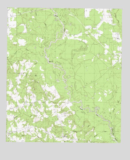
Old Center, TX USGS Topographic Map
Click on map above to begin viewing in our Map Viewer.

This topographic map contains these locations and features:
Feature Name Type Latitude Longitude GNIS ID View Map
Bounds Lake DamDamN32.1018°W94.1285°1854863View Map
Buzzard Roost BendBendN32.0752°W94.2038°1889884View Map
Coon PondLakeN32.0621°W94.2185°1889885View Map
McFaddin CreekStreamN32.0077°W94.1366°1362445View Map
Methodist Church ConcordChurchN32.0068°W94.2474°2032272View Map
Murvaul CreekStreamN32.0799°W94.2091°1388230View Map
New Prospect ChurchChurchN32.0977°W94.1285°1363765View Map
Old CenterPopulated PlaceN32.0063°W94.1877°1890055View Map
Old CenterPopulated PlaceN32.0060°W94.1883°2034784View Map
Old Center ChurchChurchN32.0066°W94.1885°1364407View Map
Old Prospect CemeteryCemeteryN32.1135°W94.1349°1364461View Map
Sixmile CreekStreamN32.0946°W94.2019°1368371View Map
Socagee CreekStreamN32.0216°W94.1410°1376169View Map
Social Point ChurchChurchN32.0052°W94.2019°1368576View Map
Toledo Bend ReservoirReservoirN32.0079°W94.1332°1889886View Map
Wilkerson CreekStreamN32.0207°W94.1441°1371539View Map
WoodsPopulated PlaceN32.0085°W94.2483°1376867View Map
Woods Volunteer Fire DepartmentBuildingN32.0486°W94.2428°2655280View Map

Note: Coordinates in the location and feature list above are referenced to NAD83 datum.


Copyright (C) 2008-2024 Ryan Niemi / Sunset Dynamics ... All Rights Reserved