TopoQuest Logo
Do you find TopoQuest useful?
Help keep TopoQuest running and adding new maps/features by donating!
Bitcoin:  19c7KJd3qBynnjoSw5npx9KScwjBe4ifkT
Litecoin:  LXs6TkuXGGXo1vDsWCkWVdjQX94eUKd6ui
Home View Maps Find Maps Find Places Resources & Links


Riverside, Pennsylvania Topographic Map

USGS Map Title: Riverside, PA
USGS Map MRC: 40076H6
DRG (GeoTIFF) Download: o40076h6.tif


Neighboring USGS Topographic Map Quads:


  Milton, PA  
41076A7
 

  Washingtonville, PA  
41076A6
 

  Millville, PA  
41076A5
 

  Northumberland, PA  
40076H7
 

  Riverside, PA  
40076H6
 

  Danville, PA  
40076H5
 

  Sunbury, PA  
40076G7
 

  Trevorton, PA  
40076G6
 

  Shamokin, PA  
40076G5


Map MRC Location:

N41°
W77°
N41°
W76°
H8 H7 H6 H5 H4 H3 H2 H1
G8 G7 G6 G5 G4 G3 G2 G1
F8 F7 F6 F5 F4 F3 F2 F1
E8 E7 E6 E5 E4 E3 E2 E1
D8 D7 D6 D5 D4 D3 D2 D1
C8 C7 C6 C5 C4 C3 C2 C1
B8 B7 B6 B5 B4 B3 B2 B1
A8 A7 A6 A5 A4 A3 A2 A1
N40°
W77°
N40°
W76°

Riverside, PA USGS 1:24K Topographic Map Preview:
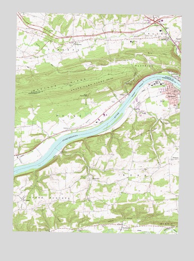
Riverside, PA USGS Topographic Map
Click on map above to begin viewing in our Map Viewer.

This topographic map contains these locations and features:
Feature Name Type Latitude Longitude GNIS ID View Map
Bald TopSummitN40.9770°W76.6419°1192093View Map
Borough of RiversideCivilN40.9461°W76.6461°1215516View Map
Brights CemeteryCemeteryN40.9876°W76.6422°1170253View Map
CameronPopulated PlaceN40.9343°W76.7075°1203213View Map
ChulaskyPopulated PlaceN40.9540°W76.6647°1171836View Map
Consolidated SchoolSchoolN40.9943°W76.6413°1197873View Map
Danville AirportAirportN40.9479°W76.6460°1194143View Map
DeiblerPopulated PlaceN40.8790°W76.6277°1203399View Map
Deibler Station ChurchChurchN40.8751°W76.6286°1173116View Map
Devils Feather BedLocaleN40.9534°W76.6933°1173204View Map
Franklin FurnacePopulated PlaceN40.9887°W76.6511°1203623View Map
Furnace HollowValleyN40.9548°W76.6650°1175356View Map
Gaskins RunStreamN40.9540°W76.6627°1175479View Map
Grace ChurchChurchN40.9306°W76.7166°1175903View Map
Gravel RunStreamN40.9212°W76.7155°1176010View Map
Indian CreekStreamN40.9945°W76.6433°1177747View Map
Kase CemeteryCemeteryN40.9487°W76.6270°1178241View Map
KeefersPopulated PlaceN40.8754°W76.7214°1203916View Map
Kipps RunPopulated PlaceN40.9459°W76.6591°1178537View Map
Kipps RunStreamN40.9495°W76.6613°1178538View Map
Klines GrovePopulated PlaceN40.9054°W76.6891°1178588View Map
Liberty Township Fire CompanyBuildingN40.9811°W76.7076°2652606View Map
Liberty Valley SchoolSchoolN40.9851°W76.6616°1179269View Map
Mahoning CreekStreamN40.9654°W76.6311°1192876View Map
MausdalePopulated PlaceN40.9865°W76.6350°1180563View Map
Mauses CreekStreamN40.9831°W76.6283°1192904View Map
MooresburgPopulated PlaceN40.9829°W76.7047°1181517View Map
Mount PleasantPopulated PlaceN40.8929°W76.7430°1213992View Map
Mount Vernon CemeteryCemeteryN40.9483°W76.6282°1181877View Map
Packers RunStreamN40.9320°W76.7016°1183176View Map
Raups RunStreamN40.9484°W76.6677°1184702View Map
Red Point HillSummitN40.9604°W76.6600°1184773View Map
RiversidePopulated PlaceN40.9554°W76.6288°1185137View Map
Riverside Borough Police DepartmentBuildingN40.9569°W76.6282°2780503View Map
Riverside Elementary SchoolSchoolN40.9559°W76.6397°1207191View Map
Riverside Post OfficePost OfficeN40.9573°W76.6289°2780042View Map
Rush ChurchChurchN40.9120°W76.6497°1185640View Map
RushtownPopulated PlaceN40.9179°W76.6297°1185646View Map
Saint Johns CemeteryCemeteryN40.8790°W76.6813°1186072View Map
Saint Johns ChurchChurchN40.9848°W76.6291°1186152View Map
Saint Peters ChurchChurchN40.9562°W76.6288°1186674View Map
SnydertownPopulated PlaceN40.8801°W76.6658°1187970View Map
South DanvillePopulated PlaceN40.9618°W76.6422°1202099View Map
Southside Fire Company Station 7 - 7BuildingN40.9597°W76.6352°2653479View Map
State Game Lands Number 115ParkN40.9576°W76.6977°1193431View Map
Township of LibertyCivilN40.9919°W76.7283°1216890View Map
Township of RushCivilN40.9099°W76.6270°1216927View Map
Upper Augusta Township Volunteer Fire Company Station 7 - 2BuildingN40.8872°W76.7417°2652818View Map
Wilson RunStreamN40.9406°W76.6405°1191548View Map
WolvertonPopulated PlaceN40.9206°W76.7133°1204981View Map
WPGM-AM (Danville)TowerN40.9862°W76.6266°1200474View Map

Note: Coordinates in the location and feature list above are referenced to NAD83 datum.


Copyright (C) 2008-2025 Ryan Niemi / Sunset Dynamics ... All Rights Reserved