TopoQuest Logo
Do you find TopoQuest useful?
Help keep TopoQuest running and adding new maps/features by donating!
Bitcoin:  19c7KJd3qBynnjoSw5npx9KScwjBe4ifkT
Litecoin:  LXs6TkuXGGXo1vDsWCkWVdjQX94eUKd6ui
Home View Maps Find Maps Find Places Resources & Links


Big Rock Flat, Oregon Topographic Map

USGS Map Title: Big Rock Flat, OR
USGS Map MRC: 45119A5
DRG (GeoTIFF) Download: o45119a5.tif


Neighboring USGS Topographic Map Quads:


  Hardman, OR  
45119B6
 

  Balm Canyon, OR  
45119B5
 

  Summerfield Ridge, OR  
45119B4
 

  Chapin Creek, OR  
45119A6
 

  Big Rock Flat, OR  
45119A5
 

  Madison Butte, OR  
45119A4
 

  Whitetail Butte, OR  
44119H6
 

  Turner Mountain, OR  
44119H5
 

  Johnny Cake Mountain, OR  
44119H4


Map MRC Location:

N46°
W120°
N46°
W119°
H8 H7 H6 H5 H4 H3 H2 H1
G8 G7 G6 G5 G4 G3 G2 G1
F8 F7 F6 F5 F4 F3 F2 F1
E8 E7 E6 E5 E4 E3 E2 E1
D8 D7 D6 D5 D4 D3 D2 D1
C8 C7 C6 C5 C4 C3 C2 C1
B8 B7 B6 B5 B4 B3 B2 B1
A8 A7 A6 A5 A4 A3 A2 A1
N45°
W120°
N45°
W119°

Big Rock Flat, OR USGS 1:24K Topographic Map Preview:
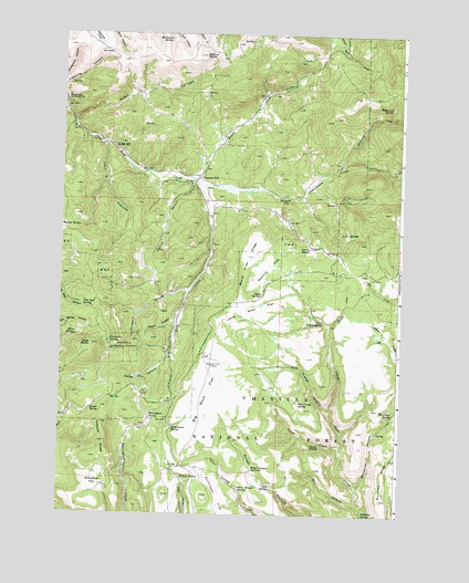
Big Rock Flat, OR USGS Topographic Map
Click on map above to begin viewing in our Map Viewer.

This topographic map contains these locations and features:
Feature Name Type Latitude Longitude GNIS ID View Map
Allen CanyonValleyN45.1026°W119.6211°1137138View Map
Allen SpringSpringN45.0463°W119.6192°1137152View Map
Anson Wright Memorial ParkParkN45.1076°W119.6242°1137228View Map
Aspen CreekStreamN45.0174°W119.5219°1150240View Map
Aspen SpringSpringN45.0185°W119.5289°1150299View Map
Barlow ButteSummitN45.1193°W119.5736°1137520View Map
Beaver Slide RidgeRidgeN45.0671°W119.5564°1137846View Map
Big Flat Airstrip (historical)AirportN45.0407°W119.5720°1157072View Map
Big Rock FlatFlatN45.0315°W119.5700°1138060View Map
Bleakman SpringSpringN45.1233°W119.5864°1138259View Map
Board CreekStreamN45.0871°W119.5764°1138349View Map
Box CanyonValleyN45.0015°W119.5131°1138528View Map
Chapin CreekStreamN45.1046°W119.6242°1139565View Map
Chickadee SpringSpringN45.0451°W119.6067°1139628View Map
Davidson CanyonValleyN45.0582°W119.5775°1140651View Map
Government SpringSpringN45.0220°W119.5834°1142886View Map
Harrington SpringSpringN45.0248°W119.5919°1143327View Map
Harris CanyonValleyN45.0863°W119.5767°1143330View Map
Hollywood CreekStreamN45.0904°W119.5236°1143672View Map
Hollywood SpringSpringN45.1061°W119.5048°1143673View Map
Hothole RidgeRidgeN45.0185°W119.6081°1143835View Map
John Z CanyonValleyN45.0965°W119.6095°1144311View Map
Keeney CreekStreamN45.0490°W119.5267°1144506View Map
Little Rock FlatFlatN45.0540°W119.5522°1145239View Map
Matlock FlatFlatN45.0646°W119.5486°1145870View Map
Matlock Spring (historical)SpringN45.0548°W119.5132°1156084View Map
Morphine CanyonValleyN45.0065°W119.5150°1146465View Map
Morphine RidgeRidgeN45.0040°W119.5064°1146467View Map
Morphine SpringSpringN45.0264°W119.5027°1146468View Map
One Trough CanyonValleyN45.0271°W119.5253°1147222View Map
One Trough SpringSpringN45.0295°W119.5373°1147223View Map
Opal ButteSummitN45.0438°W119.6133°1147242View Map
Opal SpringSpringN45.0573°W119.5515°1147250View Map
Parkers MillLocaleN45.0876°W119.5750°1147462View Map
Parkers Mills Post Office (historical)Post OfficeN45.0876°W119.5750°1164580View Map
Raber CanyonValleyN45.0418°W119.5850°1148127View Map
Reeds MillLocaleN45.0957°W119.6070°1148361View Map
Rough Canyon ReservoirReservoirN45.0119°W119.5539°1148749View Map
Shaner SpringSpringN45.0273°W119.6134°1149286View Map
Sicklebar SpringSpringN45.0001°W119.5129°1149465View Map
Snowshoe FlatFlatN45.0076°W119.6136°1149831View Map
SOB SpringSpringN45.0074°W119.5466°1148887View Map
Sperry SpringSpringN45.0689°W119.5340°1150119View Map
Sunflower FlatFlatN45.0038°W119.5658°1136986View Map
Three Trough SpringSpringN45.0067°W119.5584°1151182View Map
Toll RockPillarN45.1199°W119.6078°1151303View Map
Tree Root SpringSpringN45.0541°W119.6170°1151411View Map
Tupper CorralLocaleN45.0624°W119.5150°1156717View Map
Tupper CreekStreamN45.0857°W119.5750°1151520View Map
Tupper MeadowFlatN45.0863°W119.5336°1151522View Map
Upper Keeney SpringSpringN45.0501°W119.5281°1151683View Map
Wesler CanyonValleyN45.0499°W119.5831°1152018View Map
Wildcat SpringSpringN45.0095°W119.5804°1152351View Map

Note: Coordinates in the location and feature list above are referenced to NAD83 datum.


Copyright (C) 2008-2024 Ryan Niemi / Sunset Dynamics ... All Rights Reserved