TopoQuest Logo
Do you find TopoQuest useful?
Help keep TopoQuest running and adding new maps/features by donating!
Bitcoin:  19c7KJd3qBynnjoSw5npx9KScwjBe4ifkT
Litecoin:  LXs6TkuXGGXo1vDsWCkWVdjQX94eUKd6ui
Home View Maps Find Maps Find Places Resources & Links


Roaring River, North Carolina Topographic Map

USGS Map Title: Roaring River, NC
USGS Map MRC: 36081B1
DRG (GeoTIFF) Download: o36081b1.tif


Neighboring USGS Topographic Map Quads:


  McGrady, NC  
36081C2
 

  Traphill, NC  
36081C1
 

  Thurmond, NC  
36080C8
 

  Wilkesboro, NC  
36081B2
 

  Roaring River, NC  
36081B1
 

  Ronda, NC  
36080B8
 

  Moravian Falls, NC  
36081A2
 

  Gilreath, NC  
36081A1
 

  Osbornville, NC  
36080A8


Map MRC Location:

N37°
W82°
N37°
W81°
H8 H7 H6 H5 H4 H3 H2 H1
G8 G7 G6 G5 G4 G3 G2 G1
F8 F7 F6 F5 F4 F3 F2 F1
E8 E7 E6 E5 E4 E3 E2 E1
D8 D7 D6 D5 D4 D3 D2 D1
C8 C7 C6 C5 C4 C3 C2 C1
B8 B7 B6 B5 B4 B3 B2 B1
A8 A7 A6 A5 A4 A3 A2 A1
N36°
W82°
N36°
W81°

Roaring River, NC USGS 1:24K Topographic Map Preview:
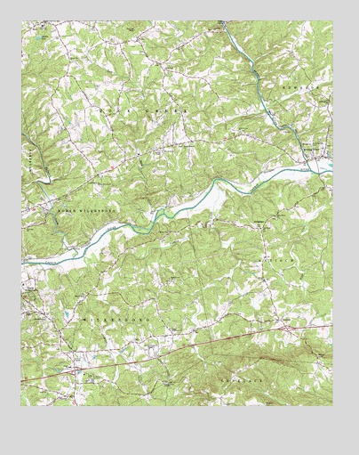
Roaring River, NC USGS Topographic Map
Click on map above to begin viewing in our Map Viewer.

This topographic map contains these locations and features:
Feature Name Type Latitude Longitude GNIS ID View Map
AntiochPopulated PlaceN36.1535°W81.0212°980204View Map
Antioch Baptist ChurchChurchN36.1660°W81.0273°980240View Map
Arbor Grove ChurchChurchN36.2143°W81.0370°980273View Map
Bethany ChurchChurchN36.2474°W81.0473°981092View Map
Bethel Branch ChurchChurchN36.2096°W81.0595°981100View Map
Bethel Church (historical)ChurchN36.1749°W81.1106°1959834View Map
Broadway Fire DepartmentBuildingN36.1521°W81.1122°2639327View Map
Bryan (historical)Populated PlaceN36.1974°W81.0456°1002158View Map
CallPopulated PlaceN36.1460°W81.0776°1019474View Map
Call Mill (historical)LocaleN36.1290°W81.0734°1959836View Map
Churchs Mill (historical)LocaleN36.2054°W81.0770°1959837View Map
Damaseus ChurchChurchN36.1532°W81.1151°983925View Map
DellaplanePopulated PlaceN36.1832°W81.0290°1006174View Map
EdgewoodPopulated PlaceN36.1285°W81.1067°1959839View Map
Edgewood Baptist ChurchChurchN36.1285°W81.1054°984639View Map
Eshol ChurchChurchN36.1301°W81.1140°984834View Map
Fairview ChurchChurchN36.1818°W81.0656°984924View Map
Fishing CreekStreamN36.1971°W81.0479°985114View Map
Fishing CreekPopulated PlaceN36.1326°W81.0656°1959840View Map
Fishing Creek Arbor ChurchChurchN36.1326°W81.0679°985118View Map
Fishing Creek ChurchChurchN36.1610°W81.0987°985119View Map
Flint Hill ChurchChurchN36.1832°W81.1217°985218View Map
Gospel Tabernacle ChurchChurchN36.1501°W81.0648°985866View Map
HaysPopulated PlaceN36.2499°W81.1156°986552View Map
Hays Census Designated PlaceCensusN36.2469°W81.1142°2402572View Map
Hays Post OfficePost OfficeN36.2496°W81.1165°2774136View Map
KnottvillePopulated PlaceN36.2046°W81.0831°1959847View Map
Knotville Volunteer Fire DepartmentBuildingN36.2009°W81.0907°2639323View Map
Liberty Grove Baptist ChurchChurchN36.1979°W81.0929°988429View Map
Little Brushy Mountain Volunteer Fire DepartmentBuildingN36.1259°W81.0431°2638434View Map
Little Mountain ChurchChurchN36.2449°W81.0776°988713View Map
Miller School (historical)SchoolN36.1587°W81.0770°1959849View Map
Mount Sinai CemeteryCemeteryN36.1260°W81.0273°990567View Map
Mountain View SchoolSchoolN36.2485°W81.1162°990730View Map
Mountain View Volunteer Fire DepartmentBuildingN36.2488°W81.1173°2639343View Map
Mulberry CreekStreamN36.1732°W81.1037°990777View Map
New River Mental Health CenterBuildingN36.1568°W81.1248°1002170View Map
North Wilkesboro SpeedwayLocaleN36.1426°W81.0723°991281View Map
Oak Forest Baptist ChurchChurchN36.1829°W81.0279°991349View Map
Oak Grove ChurchChurchN36.2085°W81.0670°991397View Map
Oak Grove School (historical)SchoolN36.2110°W81.0529°1959855View Map
Orange ChapelChurchN36.2076°W81.0692°991672View Map
Parks Grove ChurchChurchN36.1665°W81.0651°991875View Map
Parks Mill (historical)LocaleN36.1835°W81.0487°1959856View Map
Piney Ridge School (historical)SchoolN36.2274°W81.1112°1959859View Map
Rickerd ChapelChurchN36.1562°W81.1226°993328View Map
Roaring RiverPopulated PlaceN36.2065°W81.0037°993434View Map
Roaring RiverStreamN36.2018°W81.0087°993435View Map
Roaring River Elementary SchoolSchoolN36.2087°W81.0037°1959861View Map
Roaring River Post OfficePost OfficeN36.2054°W81.0089°2774274View Map
Roaring River United Methodist Cemetery - Long Bottom CemeteryCemeteryN36.2096°W81.0080°988887View Map
Roaring River Volunteer Fire DepartmentBuildingN36.2072°W81.0208°2639328View Map
Roaring River Volunteer Fire Department SubstationBuildingN36.1523°W81.0191°2639364View Map
Rock CreekStreamN36.1887°W81.0701°993488View Map
Rock Creek ChurchChurchN36.2346°W81.0670°993499View Map
Round MountainSummitN36.2471°W81.0792°1022420View Map
Round Mountain ChurchChurchN36.2371°W81.1048°993748View Map
Russaw (historical)Populated PlaceN36.1846°W81.0895°1002176View Map
Shepherds Mill (historical)LocaleN36.1579°W81.0098°1959864View Map
Township of AntiochCivilN36.1697°W81.0055°1027321View Map
Township of Rock CreekCivilN36.2394°W81.0796°1027335View Map
Township of WilkesboroCivilN36.1396°W81.1192°1027341View Map
Union Grove ChurchChurchN36.1868°W81.0229°996493View Map
White Plains Baptist ChurchChurchN36.2243°W81.0006°997197View Map
Wilkes County AirportAirportN36.2247°W81.1009°998038View Map
Wilkes LakeReservoirN36.2444°W81.1178°997334View Map
Windy GapGapN36.1415°W81.0062°997482View Map
Wright SchoolSchoolN36.1382°W81.1048°997661View Map

Note: Coordinates in the location and feature list above are referenced to NAD83 datum.


Copyright (C) 2008-2025 Ryan Niemi / Sunset Dynamics ... All Rights Reserved