TopoQuest Logo
Do you find TopoQuest useful?
Help keep TopoQuest running and adding new maps/features by donating!
Bitcoin:  19c7KJd3qBynnjoSw5npx9KScwjBe4ifkT
Litecoin:  LXs6TkuXGGXo1vDsWCkWVdjQX94eUKd6ui
Home View Maps Find Maps Find Places Resources & Links


Ronda, North Carolina Topographic Map

USGS Map Title: Ronda, NC
USGS Map MRC: 36080B8
DRG (GeoTIFF) Download: o36080b8.tif


Neighboring USGS Topographic Map Quads:


  Traphill, NC  
36081C1
 

  Thurmond, NC  
36080C8
 

  Elkin North, NC  
36080C7
 

  Roaring River, NC  
36081B1
 

  Ronda, NC  
36080B8
 

  Elkin South, NC  
36080B7
 

  Gilreath, NC  
36081A1
 

  Osbornville, NC  
36080A8
 

  Brooks Crossroads, NC  
36080A7


Map MRC Location:

N37°
W81°
N37°
W80°
H8 H7 H6 H5 H4 H3 H2 H1
G8 G7 G6 G5 G4 G3 G2 G1
F8 F7 F6 F5 F4 F3 F2 F1
E8 E7 E6 E5 E4 E3 E2 E1
D8 D7 D6 D5 D4 D3 D2 D1
C8 C7 C6 C5 C4 C3 C2 C1
B8 B7 B6 B5 B4 B3 B2 B1
A8 A7 A6 A5 A4 A3 A2 A1
N36°
W81°
N36°
W80°

Ronda, NC USGS 1:24K Topographic Map Preview:
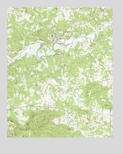
Ronda, NC USGS Topographic Map
Click on map above to begin viewing in our Map Viewer.

This topographic map contains these locations and features:
Feature Name Type Latitude Longitude GNIS ID View Map
Adams HollowValleyN36.1313°W80.9223°980044View Map
Allin (historical)Populated PlaceN36.2318°W80.9573°1002156View Map
Bethel ChurchChurchN36.2129°W80.9012°981166View Map
Big Bugaboo CreekStreamN36.2165°W80.9617°981369View Map
Brier CreekStreamN36.1982°W80.9959°981888View Map
Brier Creek (historical)Populated PlaceN36.1937°W80.9979°1018644View Map
Brier Creek Baptist ChurchChurchN36.1968°W80.9645°981889View Map
Byrd MountainSummitN36.1410°W80.9965°1019461View Map
ClingmanPopulated PlaceN36.1785°W80.9279°983291View Map
Cranberry ChurchChurchN36.1540°W80.9873°983704View Map
Dark MountainSummitN36.1454°W80.9670°983960View Map
Dennyville ChurchChurchN36.1518°W80.8995°984136View Map
Dimmette (historical)Populated PlaceN36.2479°W80.9376°1959983View Map
Dobins HollowValleyN36.1418°W80.9550°984237View Map
East Swan CreekStreamN36.2110°W80.8973°984541View Map
East Wilkes High SchoolSchoolN36.2262°W80.9279°984545View Map
Engle HollowValleyN36.1405°W80.9429°984789View Map
Gobblers KnobSummitN36.1332°W80.9276°985753View Map
Grays CreekStreamN36.2024°W80.9542°985998View Map
Horde MountainSummitN36.1737°W80.8998°1020834View Map
Hughes BranchStreamN36.2149°W80.9323°987228View Map
Jarvis Mill (historical)LocaleN36.1543°W80.9954°1959997View Map
Jarvis Store (historical)LocaleN36.1515°W80.9342°1959998View Map
Little Bugaboo CreekStreamN36.2354°W80.9609°988562View Map
Little Elkin CreekStreamN36.2354°W80.8923°988633View Map
Macedonia ChurchChurchN36.2465°W80.9370°989201View Map
Martin (historical)Populated PlaceN36.2024°W80.9842°1002167View Map
Mathis MountainSummitN36.1376°W80.9737°1021366View Map
Miller DamDamN36.1851°W80.9081°1000282View Map
Mount Valley ChurchChurchN36.1546°W80.9509°990592View Map
New Castle (historical)Populated PlaceN36.1665°W80.9556°1002169View Map
NonameReservoirN36.1851°W80.9081°1000283View Map
Oakley RidgeRidgeN36.1304°W80.9792°991483View Map
Old Brier Creek CemeteryCemeteryN36.1962°W80.9654°1960011View Map
Piney Grove ChurchChurchN36.2085°W80.9170°992363View Map
Pleasant Grove Baptist ChurchChurchN36.1685°W80.9334°992499View Map
Poplar Springs Missionary Baptist ChurchChurchN36.2324°W80.9856°992711View Map
Redding MountainSummitN36.1499°W80.9092°1022204View Map
RondaPopulated PlaceN36.2185°W80.9412°993667View Map
Ronda Community Volunteer Fire DepartmentBuildingN36.2186°W80.9413°2639263View Map
Ronda Post OfficePost OfficeN36.2171°W80.9427°2774278View Map
Ronda-Clingman SchoolSchoolN36.2049°W80.9373°993668View Map
Segraves MountainSummitN36.1551°W80.8798°994487View Map
Swan CreekStreamN36.2201°W80.8965°995745View Map
Temple Hill ChurchChurchN36.1371°W80.9223°995922View Map
Town of RondaCivilN36.2217°W80.9432°2407238View Map
Township of New CastleCivilN36.1719°W80.9178°1027332View Map
Weatherspon (historical)Populated PlaceN36.2110°W80.8973°1002178View Map
Wells Mill (historical)LocaleN36.1387°W80.9154°1960033View Map
West Swan CreekStreamN36.2115°W80.8973°997050View Map
Wildcat LakeReservoirN36.1485°W80.8815°1000196View Map
Wildcat Lake DamDamN36.1485°W80.8815°1000195View Map
Wilkes TempleChurchN36.1485°W80.9248°997335View Map
Wright DamDamN36.1418°W80.9015°1000171View Map
Wright LakeReservoirN36.1418°W80.9015°1000172View Map

Note: Coordinates in the location and feature list above are referenced to NAD83 datum.


Copyright (C) 2008-2024 Ryan Niemi / Sunset Dynamics ... All Rights Reserved