TopoQuest Logo
Do you find TopoQuest useful?
Help keep TopoQuest running and adding new maps/features by donating!
Bitcoin:  19c7KJd3qBynnjoSw5npx9KScwjBe4ifkT
Litecoin:  LXs6TkuXGGXo1vDsWCkWVdjQX94eUKd6ui
Home View Maps Find Maps Find Places Resources & Links


Gilreath, North Carolina Topographic Map

USGS Map Title: Gilreath, NC
USGS Map MRC: 36081A1
DRG (GeoTIFF) Download: o36081a1.tif


Neighboring USGS Topographic Map Quads:


  Wilkesboro, NC  
36081B2
 

  Roaring River, NC  
36081B1
 

  Ronda, NC  
36080B8
 

  Moravian Falls, NC  
36081A2
 

  Gilreath, NC  
36081A1
 

  Osbornville, NC  
36080A8
 

  Taylorsville, NC  
35081H2
 

  Hiddenite, NC  
35081H1
 

  Central, NC  
35080H8


Map MRC Location:

N37°
W82°
N37°
W81°
H8 H7 H6 H5 H4 H3 H2 H1
G8 G7 G6 G5 G4 G3 G2 G1
F8 F7 F6 F5 F4 F3 F2 F1
E8 E7 E6 E5 E4 E3 E2 E1
D8 D7 D6 D5 D4 D3 D2 D1
C8 C7 C6 C5 C4 C3 C2 C1
B8 B7 B6 B5 B4 B3 B2 B1
A8 A7 A6 A5 A4 A3 A2 A1
N36°
W82°
N36°
W81°

Gilreath, NC USGS 1:24K Topographic Map Preview:
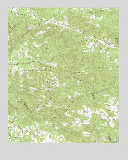
Gilreath, NC USGS Topographic Map
Click on map above to begin viewing in our Map Viewer.

This topographic map contains these locations and features:
Feature Name Type Latitude Longitude GNIS ID View Map
Bakers Grove ChurchChurchN36.0249°W81.0087°980455View Map
Bethany ChurchChurchN36.0721°W81.1209°981089View Map
Bethany Church (historical)ChurchN36.0482°W81.0917°1959971View Map
Bethel ChurchChurchN36.0176°W81.1176°981159View Map
Big R OrchardsLocaleN36.0697°W81.1147°2633199View Map
Brushy Mountain Volunteer Fire DepartmentBuildingN36.0724°W81.1200°2639362View Map
Cherry Grove Baptist ChurchChurchN36.0824°W81.0651°983082View Map
Cherry Grove CemeteryCemeteryN36.0796°W81.0676°983080View Map
Christ ChurchChurchN36.1085°W81.0798°983166View Map
D H OrchardsLocaleN36.0814°W81.1156°2633201View Map
Deater DamDamN36.0568°W81.0398°999996View Map
Debs KnobSummitN36.1065°W81.1045°1959982View Map
Dwight Baity DamDamN36.0835°W81.1115°1000039View Map
Fox Mountain LakeReservoirN36.0034°W81.0038°999891View Map
Fox Mountain Lake DamDamN36.0035°W81.0015°999892View Map
GilreathPopulated PlaceN36.0499°W81.0784°1020434View Map
Gilreath School (historical)SchoolN36.0937°W81.0829°1959988View Map
Hendren Mill (historical)LocaleN36.0329°W81.0909°1959994View Map
Hunting Creek (historical)Populated PlaceN36.1065°W81.0729°1002162View Map
Hunting Creek CemeteryCemeteryN36.0993°W81.0370°987265View Map
Hunting Creek ChurchChurchN36.1018°W81.0392°987267View Map
Kennedy Store (historical)LocaleN36.0465°W81.0481°1959999View Map
Lewis ChurchChurchN36.0812°W81.0126°988389View Map
Liberty ChurchChurchN36.0576°W81.0781°988419View Map
Lowell Hendren OrchardsLocaleN36.0667°W81.1114°2633203View Map
Mount Sinai ChurchChurchN36.1249°W81.0270°990577View Map
New Hope ChurchChurchN36.0740°W81.1006°991018View Map
NonameReservoirN36.0568°W81.0398°999995View Map
NonameReservoirN36.0835°W81.1115°1000040View Map
Old Bethany CemeteryCemeteryN36.0479°W81.0912°991529View Map
Old GilreathPopulated PlaceN36.0743°W81.1173°1021732View Map
Parker's OrchardLocaleN36.0758°W81.1150°2633205View Map
Pilot MountainSummitN36.0962°W81.0737°1960013View Map
Pole MountainSummitN36.1237°W81.0912°1960015View Map
Rich MountainSummitN36.1218°W81.0873°1960018View Map
Smiths Grove ChurchChurchN36.0160°W81.0726°995006View Map
Spurgeon (historical)Populated PlaceN36.0918°W81.0256°1960026View Map
Tevepaugh OrchardsLocaleN36.0739°W81.0808°2633207View Map
Township of Brushy MountainCivilN36.0659°W81.0887°1027324View Map
Township of LovelaceCivilN36.0997°W81.0340°1027329View Map
Vashti Volunteer Fire DepartmentBuildingN36.0074°W81.1082°2639181View Map

Note: Coordinates in the location and feature list above are referenced to NAD83 datum.


Copyright (C) 2008-2024 Ryan Niemi / Sunset Dynamics ... All Rights Reserved