TopoQuest Logo
Do you find TopoQuest useful?
Help keep TopoQuest running and adding new maps/features by donating!
Bitcoin:  19c7KJd3qBynnjoSw5npx9KScwjBe4ifkT
Litecoin:  LXs6TkuXGGXo1vDsWCkWVdjQX94eUKd6ui
Home View Maps Find Maps Find Places Resources & Links


Roberts Lake, Wisconsin Topographic Map

USGS Map Title: Roberts Lake, WI
USGS Map MRC: 45088D7
DRG (GeoTIFF) Download: o45088d7.tif


Neighboring USGS Topographic Map Quads:


  Crandon, WI  
45088E8
 

  Lake Lucerne, WI  
45088E7
 

  Laona, WI  
45088E6
 

  Mole Lake, WI  
45088D8
 

  Roberts Lake, WI  
45088D7
 

  Wabeno, WI  
45088D6
 

  Pickerel, WI  
45088C8
 

  Lily, WI  
45088C7
 

  Reservoir Pond, WI  
45088C6


Map MRC Location:

N46°
W89°
N46°
W88°
H8 H7 H6 H5 H4 H3 H2 H1
G8 G7 G6 G5 G4 G3 G2 G1
F8 F7 F6 F5 F4 F3 F2 F1
E8 E7 E6 E5 E4 E3 E2 E1
D8 D7 D6 D5 D4 D3 D2 D1
C8 C7 C6 C5 C4 C3 C2 C1
B8 B7 B6 B5 B4 B3 B2 B1
A8 A7 A6 A5 A4 A3 A2 A1
N45°
W89°
N45°
W88°

Roberts Lake, WI USGS 1:24K Topographic Map Preview:
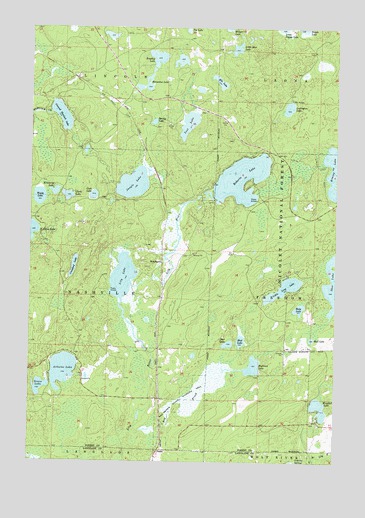
Roberts Lake, WI USGS Topographic Map
Click on map above to begin viewing in our Map Viewer.

This topographic map contains these locations and features:
Feature Name Type Latitude Longitude GNIS ID View Map
Arbutus LakeLakeN45.4014°W88.8613°1578665View Map
Bog BrookStreamN45.3833°W88.8326°1578824View Map
Bog Brook 2WP1571 DamDamN45.3850°W88.8218°1792775View Map
Bog Brook FlowageReservoirN45.3850°W88.8218°1792776View Map
Bog Brook State Wildlife AreaParkN45.3944°W88.8115°1578825View Map
Bogbrook ImpoundmentReservoirN45.3852°W88.8190°2783866View Map
Bogbrook LakeLakeN45.4025°W88.7836°1578827View Map
Bradley LakeLakeN45.4913°W88.8237°1578856View Map
ChoatePopulated PlaceN45.3780°W88.8223°1578999View Map
Clark LakeLakeN45.4514°W88.8600°1579013View Map
Cook LakeLakeN45.4516°W88.8496°1579038View Map
Crawford LakeLakeN45.4312°W88.8573°1579060View Map
Deer LakeLakeN45.4089°W88.7939°1579101View Map
Donut LakeLakeN45.4904°W88.8142°2783886View Map
Eds LakeLakeN45.4844°W88.7982°1579192View Map
Eds Lake Trail SystemTrailN45.4755°W88.7868°1581005View Map
Grass LakeLakeN45.3964°W88.8707°1579354View Map
Ground Hemlock LakeLakeN45.4746°W88.8628°1579366View Map
Himley LakeLakeN45.4592°W88.7518°1579458View Map
Horseshoe LakeLakeN45.4828°W88.8273°1579482View Map
Jungle LakeLakeN45.4549°W88.8333°1579560View Map
Kimberly LakeLakeN45.4526°W88.8653°1579590View Map
Lily LakeLakeN45.4283°W88.8371°1579655View Map
Little Long LakeLakeN45.4250°W88.7712°1579690View Map
Little Star LakeLakeN45.4940°W88.7914°1579716View Map
Lost LakeLakeN45.4723°W88.8109°1579764View Map
Ludington LakeLakeN45.4770°W88.7699°1579784View Map
Mud LakeLakeN45.4099°W88.7887°1579951View Map
Mud LakeLakeN45.4104°W88.7597°1579952View Map
Pig Snout SidingLocaleN45.4683°W88.8312°1837799View Map
Roberts LakeLakeN45.4566°W88.7890°1580269View Map
Roxy LakeLakeN45.4192°W88.7649°1580297View Map
Shoe LakeLakeN45.4275°W88.7510°1580398View Map
Spring LakeLakeN45.4728°W88.8251°1580496View Map
Walsh LakeLakeN45.4510°W88.8716°1580723View Map
Windfall LakeLakeN45.3905°W88.7564°1580801View Map
WoodlawnPopulated PlaceN45.4322°W88.8215°1580828View Map

Note: Coordinates in the location and feature list above are referenced to NAD83 datum.


Copyright (C) 2008-2025 Ryan Niemi / Sunset Dynamics ... All Rights Reserved