TopoQuest Logo
Do you find TopoQuest useful?
Help keep TopoQuest running and adding new maps/features by donating!
Bitcoin:  19c7KJd3qBynnjoSw5npx9KScwjBe4ifkT
Litecoin:  LXs6TkuXGGXo1vDsWCkWVdjQX94eUKd6ui
Home View Maps Find Maps Find Places Resources & Links


Rock Hill, Mississippi Topographic Map

USGS Map Title: Rock Hill, MS
USGS Map MRC: 31089A3
DRG (GeoTIFF) Download: o31089a3.tif


Neighboring USGS Topographic Map Quads:


  Purvis, MS  
31089B4
 

  Dixie, MS  
31089B3
 

  McLaurin, MS  
31089B2
 

  Lumberton, MS  
31089A4
 

  Rock Hill, MS  
31089A3
 

  Brooklyn, MS  
31089A2
 

  Hillsdale, MS  
30089H4
 

  Carnes, MS  
30089H3
 

  Bond, MS  
30089H2


Map MRC Location:

N32°
W90°
N32°
W89°
H8 H7 H6 H5 H4 H3 H2 H1
G8 G7 G6 G5 G4 G3 G2 G1
F8 F7 F6 F5 F4 F3 F2 F1
E8 E7 E6 E5 E4 E3 E2 E1
D8 D7 D6 D5 D4 D3 D2 D1
C8 C7 C6 C5 C4 C3 C2 C1
B8 B7 B6 B5 B4 B3 B2 B1
A8 A7 A6 A5 A4 A3 A2 A1
N31°
W90°
N31°
W89°

Rock Hill, MS USGS 1:24K Topographic Map Preview:
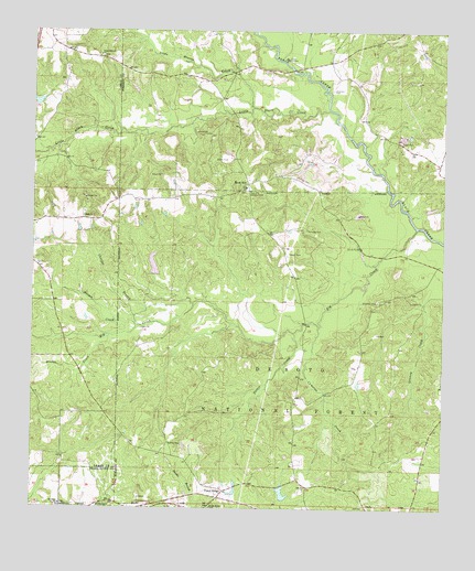
Rock Hill, MS USGS Topographic Map
Click on map above to begin viewing in our Map Viewer.

This topographic map contains these locations and features:
Feature Name Type Latitude Longitude GNIS ID View Map
Anderson CemeteryCemeteryN31.1096°W89.2837°692396View Map
Attix Lake DamDamN31.0785°W89.2551°695349View Map
Battson CemeteryCemeteryN31.0171°W89.3334°692472View Map
Big CreekStreamN31.0738°W89.2581°692597View Map
Big Creek Landing Recreation AreaParkN31.0705°W89.2542°711511View Map
Bridge CreekStreamN31.0455°W89.3512°692704View Map
Bunk BranchStreamN31.1107°W89.2856°706333View Map
Cameron CemeteryCemeteryN31.0730°W89.2914°692805View Map
Cameron CreekStreamN31.0480°W89.2876°692807View Map
Camp DantzlerLocaleN31.1180°W89.2981°692815View Map
Charles BranchStreamN31.0538°W89.3256°692879View Map
Circle One Airstrip (historical)AirportN31.0863°W89.2931°695262View Map
Clear Branch ChurchChurchN31.1188°W89.3548°692924View Map
Dearman Church (historical)ChurchN31.0807°W89.3506°705130View Map
Elder Ridge ChurchChurchN31.0007°W89.3203°693166View Map
Forrest County HomeLocaleN31.0682°W89.2753°704769View Map
Komp Lake DamDamN31.1052°W89.3734°695353View Map
Laura Leake Lake DamDamN31.0035°W89.2984°695338View Map
Little Beaver CreekStreamN31.1049°W89.3084°693742View Map
Little Black CreekStreamN31.1043°W89.2851°693745View Map
McLaurin Volunteer Fire Department Station 2BuildingN31.1165°W89.2864°2332809View Map
Mount Olive ChurchChurchN31.0013°W89.3659°694077View Map
Pistol RidgePopulated PlaceN31.0032°W89.3181°694411View Map
Pistol RidgeRidgeN31.0196°W89.3487°707471View Map
Potato CreekStreamN31.0463°W89.2951°694461View Map
Rock HillPopulated PlaceN31.0852°W89.3095°694590View Map
Rock Hill CemeteryCemeteryN31.0827°W89.3103°706360View Map
Rock Hill Church (historical)CemeteryN31.0916°W89.2934°704784View Map
Rock Hill Lookout TowerTowerN31.0835°W89.3089°711304View Map
Simmons CemeteryCemeteryN31.0546°W89.2698°694794View Map
Slade CemeteryCemeteryN31.0771°W89.3595°707481View Map
Slade ChurchChurchN31.0766°W89.3598°694810View Map
Sleeper CreekStreamN31.0477°W89.3431°694815View Map
Supervisor District 5CivilN31.0301°W89.2590°711847View Map
Tracy (historical)LocaleN31.0010°W89.2895°706363View Map
Truman Roberts Lake DamDamN31.0585°W89.3367°695346View Map
Tyner School (historical)SchoolN31.1202°W89.3665°705136View Map

Note: Coordinates in the location and feature list above are referenced to NAD83 datum.


Copyright (C) 2008-2024 Ryan Niemi / Sunset Dynamics ... All Rights Reserved