TopoQuest Logo
Do you find TopoQuest useful?
Help keep TopoQuest running and adding new maps/features by donating!
Bitcoin:  19c7KJd3qBynnjoSw5npx9KScwjBe4ifkT
Litecoin:  LXs6TkuXGGXo1vDsWCkWVdjQX94eUKd6ui
Home View Maps Find Maps Find Places Resources & Links


Rock Hill East, South Carolina Topographic Map

USGS Map Title: Rock Hill East, SC
USGS Map MRC: 34080H8
DRG (GeoTIFF) Download: o34080h8.tif


Neighboring USGS Topographic Map Quads:


  Lake Wylie, SC  
35081A1
 

  Fort Mill, SC  
35080A8
 

  Weddington, NC  
35080A7
 

  Rock Hill West, SC  
34081H1
 

  Rock Hill East, SC  
34080H8
 

  Catawba NE, SC  
34080H7
 

  Edgemoor, SC  
34081G1
 

  Catawba, SC  
34080G8
 

  Van Wyck, SC  
34080G7


Map MRC Location:

N35°
W81°
N35°
W80°
H8 H7 H6 H5 H4 H3 H2 H1
G8 G7 G6 G5 G4 G3 G2 G1
F8 F7 F6 F5 F4 F3 F2 F1
E8 E7 E6 E5 E4 E3 E2 E1
D8 D7 D6 D5 D4 D3 D2 D1
C8 C7 C6 C5 C4 C3 C2 C1
B8 B7 B6 B5 B4 B3 B2 B1
A8 A7 A6 A5 A4 A3 A2 A1
N34°
W81°
N34°
W80°

Rock Hill East, SC USGS 1:24K Topographic Map Preview:
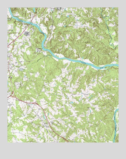
Rock Hill East, SC USGS Topographic Map
Click on map above to begin viewing in our Map Viewer.

This topographic map contains these locations and features:
Feature Name Type Latitude Longitude GNIS ID View Map
Big Dutchman CreekStreamN34.9910°W80.9940°1220698View Map
Burgis CreekStreamN34.9435°W80.8984°1221136View Map
Catawba Baptist ChurchChurchN34.9063°W80.9640°1247187View Map
Catawba Indian School (historical)SchoolN34.9071°W80.8895°1233635View Map
Catawba ReservationCivilN34.9047°W80.8837°1233634View Map
CedarwoodPopulated PlaceN34.9829°W80.9970°1233647View Map
Church of God (historical)ChurchN34.9949°W80.9431°1233659View Map
County Technical Education CenterSchoolN34.9351°W80.9954°1221776View Map
Cross Road Baptist ChurchChurchN34.9665°W80.9806°1247441View Map
Cross Roads School (historical)SchoolN34.9613°W80.9990°1233683View Map
Crossroads School (historical)SchoolN34.9671°W80.9812°1237453View Map
Dobys Bridge ChurchChurchN34.9679°W80.9106°1222043View Map
Dye BranchStreamN34.9854°W80.9656°1222168View Map
Fort Mill Middle SchoolSchoolN34.9996°W80.9398°1233730View Map
Foundation ChurchChurchN34.9204°W80.9265°1222512View Map
Foundation School (historical)SchoolN34.9201°W80.9270°1233734View Map
Four Mile CreekStreamN34.9432°W80.8984°1233735View Map
FriendshipPopulated PlaceN34.9207°W80.9145°1222568View Map
Friendship United Methodist ChurchChurchN34.9071°W80.9084°1247844View Map
Glen Rock ChurchChurchN34.9860°W80.9220°1222719View Map
Goat IslandIslandN34.9451°W80.8873°1222735View Map
Haggins BranchStreamN34.9063°W80.8776°1222964View Map
Herrons Ferry (historical)CrossingN34.9863°W80.9751°1233754View Map
Hidden CreekStreamN34.9891°W80.9902°2071368View Map
Hillcrest SchoolSchoolN34.8932°W80.9495°1245994View Map
Hopewell CemeteryCemeteryN34.8835°W80.9645°1223284View Map
Hopewell Presbyterian ChurchChurchN34.8924°W80.9565°1246055View Map
Hutchinson AcresPopulated PlaceN34.9599°W80.9901°1233762View Map
Independence Elementary SchoolSchoolN34.9049°W80.9751°1233764View Map
Interchange 75CrossingN34.8871°W80.9940°1228251View Map
Interchange 77CrossingN34.9124°W80.9787°1228252View Map
Interchange 79CrossingN34.9396°W80.9681°1228253View Map
Interchange 82CrossingN34.9738°W80.9862°1228254View Map
Interchange 83CrossingN34.9993°W80.9759°1228255View Map
Jerusalem ChurchChurchN34.9888°W80.9492°1223570View Map
Jones BranchStreamN34.9943°W80.9659°1223630View Map
Kingdom Hall ChurchChurchN34.9763°W80.9987°1223737View Map
Leslie WoodsPopulated PlaceN34.8974°W80.9348°1233780View Map
LessliePopulated PlaceN34.8907°W80.9565°1223879View Map
Lesslie Census Designated PlaceCensusN34.8856°W80.9541°2403231View Map
Lesslie Elementary SchoolSchoolN34.8957°W80.9620°1233781View Map
Lesslie Fire Department Station 1BuildingN34.8910°W80.9563°2578892View Map
Lesslie Fire Department Station 2BuildingN34.9199°W80.9145°2578893View Map
Manchester CreekStreamN34.9560°W80.9490°1224288View Map
Massey School (historical)SchoolN34.9929°W80.9176°1233791View Map
McCorkle PondReservoirN34.9901°W80.9315°1240371View Map
McCorkle Pond Dam D-1246DamN34.9901°W80.9315°1240370View Map
Mims LakeLakeN34.9827°W80.9351°1246687View Map
Mount Hebron ChurchChurchN34.8940°W80.9512°1249581View Map
Mount Zion ChurchChurchN34.9018°W80.9954°1224841View Map
Nations FordCrossingN34.9793°W80.9634°1233812View Map
Nauvassee (historical)Populated PlaceN34.9918°W80.9248°1233813View Map
Pecan GrovePopulated PlaceN34.9718°W80.9956°1233841View Map
Pleasant Valley ChurchChurchN34.9932°W80.9176°1250192View Map
RavenwoodPopulated PlaceN34.9101°W80.9331°1233862View Map
Red RiverPopulated PlaceN34.9610°W80.9654°1250314View Map
Red River Church (historical)ChurchN34.9568°W80.9692°1237460View Map
Red River School (historical)SchoolN34.9588°W80.9665°1233868View Map
Rock Grove African Methodist Episcopal Zion ChurchChurchN34.9107°W80.9967°1250416View Map
Rock Hill Fire Department Station 3BuildingN34.9726°W80.9918°2578487View Map
Rock Hill Fire Department Station 5BuildingN34.9347°W80.9617°2578901View Map
Rock Hill High SchoolSchoolN34.9024°W80.9801°1233879View Map
Rock Hill Industrial ParkLocaleN34.9504°W80.9926°1233880View Map
Rock Hill Mall Shopping CenterLocaleN34.9668°W80.9942°1233881View Map
South Carolina Highway Patrol Troop Four Post BBuildingN34.9345°W80.9969°2734326View Map
South Carolina Noname 46028 D-3649 DamDamN34.9968°W80.9698°1238568View Map
Spring ValleyPopulated PlaceN34.9113°W80.9298°1233923View Map
Springdale AcresPopulated PlaceN34.9251°W80.9598°1233924View Map
SpringsteinPopulated PlaceN34.9307°W80.9565°1233925View Map
Sturgis EstatesPopulated PlaceN34.9340°W80.9776°1233930View Map
Sun View Lake D-0579 DamDamN34.9668°W80.9115°1237594View Map
Sunrise AcresPopulated PlaceN34.9110°W80.9981°1233933View Map
Sunview LakeReservoirN34.9668°W80.9115°1237595View Map
Temple ChurchChurchN34.9618°W80.9676°1237464View Map
Williams LakeReservoirN34.9123°W80.9270°1240369View Map
Williams Lake Dam D-3650DamN34.9118°W80.9265°1240368View Map
Woodhaven Baptist ChurchChurchN34.9451°W80.9973°1251495View Map
WoodvalePopulated PlaceN34.9293°W80.9881°1233979View Map
Woodvale Baptist ChurchChurchN34.9293°W80.9865°1251511View Map
York Plaza Shopping CenterLocaleN34.9690°W80.9951°1233987View Map
York Technical CollegeSchoolN34.9354°W80.9951°1233989View Map
YorkdalePopulated PlaceN34.9065°W80.9290°1233991View Map

Note: Coordinates in the location and feature list above are referenced to NAD83 datum.


Copyright (C) 2008-2024 Ryan Niemi / Sunset Dynamics ... All Rights Reserved