TopoQuest Logo
Do you find TopoQuest useful?
Help keep TopoQuest running and adding new maps/features by donating!
Bitcoin:  19c7KJd3qBynnjoSw5npx9KScwjBe4ifkT
Litecoin:  LXs6TkuXGGXo1vDsWCkWVdjQX94eUKd6ui
Home View Maps Find Maps Find Places Resources & Links


Catawba NE, South Carolina Topographic Map

USGS Map Title: Catawba NE, SC
USGS Map MRC: 34080H7
DRG (GeoTIFF) Download: o34080h7.tif


Neighboring USGS Topographic Map Quads:


  Fort Mill, SC  
35080A8
 

  Weddington, NC  
35080A7
 

  Matthews, NC  
35080A6
 

  Rock Hill East, SC  
34080H8
 

  Catawba NE, SC  
34080H7
 

  Waxhaw, NC  
34080H6
 

  Catawba, SC  
34080G8
 

  Van Wyck, SC  
34080G7
 

  Unity, SC  
34080G6


Map MRC Location:

N35°
W81°
N35°
W80°
H8 H7 H6 H5 H4 H3 H2 H1
G8 G7 G6 G5 G4 G3 G2 G1
F8 F7 F6 F5 F4 F3 F2 F1
E8 E7 E6 E5 E4 E3 E2 E1
D8 D7 D6 D5 D4 D3 D2 D1
C8 C7 C6 C5 C4 C3 C2 C1
B8 B7 B6 B5 B4 B3 B2 B1
A8 A7 A6 A5 A4 A3 A2 A1
N34°
W81°
N34°
W80°

Catawba NE, SC USGS 1:24K Topographic Map Preview:
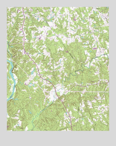
Catawba NE, SC USGS Topographic Map
Click on map above to begin viewing in our Map Viewer.

This topographic map contains these locations and features:
Feature Name Type Latitude Longitude GNIS ID View Map
Banks ChurchChurchN34.9938°W80.8181°980524View Map
Banks Presbyterian Church CemeteryCemeteryN34.9930°W80.8165°2778863View Map
Banks Presbyterian Church CemeteryCemeteryN34.9931°W80.8188°2778865View Map
BelairPopulated PlaceN34.9532°W80.8506°1241597View Map
Belair ChurchChurchN34.9515°W80.8434°1245038View Map
Bends Grove Church CemeteryCemeteryN34.9740°W80.7712°2778831View Map
Black Horse RunPopulated PlaceN34.9990°W80.8467°1241602View Map
Bonds Grove ChurchChurchN34.9746°W80.7709°981709View Map
Bowers PondReservoirN34.9327°W80.8427°1237692View Map
Bowers Pond D-1745 DamDamN34.9335°W80.8448°1237691View Map
Cow BranchStreamN34.9860°W80.8437°983630View Map
Cowhorn BranchStreamN34.9635°W80.7992°983653View Map
Dobys BridgeBridgeN34.9507°W80.8687°1241629View Map
East Fork Twelvemile CreekStreamN34.9526°W80.7534°984508View Map
Elbethel ChurchChurchN34.9624°W80.8292°1247649View Map
Elbethel School (historical)SchoolN34.9599°W80.8217°1241635View Map
Gold Hill ChurchChurchN34.9090°W80.8470°1245759View Map
Gold Hill School (historical)SchoolN34.9079°W80.8470°1241659View Map
HancockPopulated PlaceN34.9082°W80.8106°1245896View Map
Hawk's Knoll AirportAirportN34.9981°W80.8025°2679278View Map
Heath Memorial ChurchChurchN34.8890°W80.7831°986573View Map
Heath Memorial Church CemeteryCemeteryN34.8889°W80.7835°2778868View Map
Indian Land ChurchChurchN34.9324°W80.8353°1246119View Map
Indian Land Elementary SchoolSchoolN34.9535°W80.8487°1246120View Map
Indian Land Fire Department Station 10BuildingN34.9306°W80.8307°2578464View Map
Indian Land High SchoolSchoolN34.9538°W80.8531°1241678View Map
Jackson Pond Dam D-1751DamN34.8935°W80.8015°1239192View Map
Johnston Pond D-1746 DamDamN34.9218°W80.8431°1239195View Map
Long BranchStreamN34.9496°W80.8184°1224142View Map
Macedonia ChurchChurchN34.8974°W80.8554°1246508View Map
MarvinPopulated PlaceN34.9918°W80.8148°1027423View Map
Marvin Zion Church CemeteryCemeteryN34.9921°W80.8038°2778864View Map
Millstone BranchStreamN34.8751°W80.8334°1224582View Map
Morrison BranchStreamN34.9246°W80.8662°1248878View Map
Nesbit Farms Incorporated Pond Number One D-1747 DamDamN34.9068°W80.8648°1239194View Map
Nesbit Farms Incorporated Pond Number Two D-1749 DamDamN34.9085°W80.8681°1239190View Map
Osceola ChurchChurchN34.9068°W80.8098°1249996View Map
Osceola School (historical)SchoolN34.9068°W80.8087°1241732View Map
Pleasant Pines ChurchChurchN34.9890°W80.7715°992556View Map
Pleasant Valley CemeteryCemeteryN34.9932°W80.8495°1241739View Map
Pleasant Valley ChurchChurchN34.9938°W80.8501°1250193View Map
Pleasant Valley Fire Department Station 14BuildingN34.9911°W80.8642°2578674View Map
Pleasant Valley School (historical)SchoolN34.9907°W80.8540°1241741View Map
Price ChapelChurchN34.9418°W80.7612°992808View Map
Price Chapel CemeteryCemeteryN34.9416°W80.7617°2778866View Map
Providence ChurchChurchN34.9446°W80.7545°992863View Map
Redding Springs ChurchChurchN34.9888°W80.7515°993144View Map
Rehobeth ChurchChurchN34.8882°W80.7603°993228View Map
Rehobeth Presbyterian Church CemeteryCemeteryN34.8882°W80.7604°2778869View Map
Rone BranchStreamN34.9157°W80.8120°993669View Map
Schewzyk Pond Dam D-1750DamN34.9685°W80.8348°1239189View Map
Six Mile CemeteryCemeteryN34.9310°W80.8317°1241763View Map
Sixmile CreekStreamN34.9168°W80.8115°1027460View Map
Sixmile Creek ChurchChurchN34.9313°W80.8326°1250915View Map
Steel Hill ChurchChurchN34.8899°W80.7984°1251036View Map
Steel Hill School (historical)SchoolN34.8826°W80.7970°1241770View Map
Sugar CreekStreamN34.9418°W80.8706°995644View Map
Surgery Center at EdgewaterHospitalN34.9967°W80.8584°2640106View Map
Tar Kiln BranchStreamN34.9354°W80.8181°1251119View Map
Union Emergency Medical ServicesBuildingN34.9893°W80.7869°2720424View Map
Van Wyck DivisionCivilN34.9185°W80.8447°1938452View Map
Waxhaw Police DepartmentBuildingN34.9433°W80.7539°2769759View Map
Wesley Chapel Volunteer Fire Department Station 31BuildingN34.9894°W80.7870°2638435View Map
West Fork Twelvemile CreekStreamN34.9529°W80.7534°997020View Map
Wikoff Pond Dam D-1748DamN34.8935°W80.8465°1239193View Map
Wolfville (historical)Populated PlaceN34.9532°W80.7540°1002295View Map
Zion ChurchChurchN34.9921°W80.8034°997760View Map

Note: Coordinates in the location and feature list above are referenced to NAD83 datum.


Copyright (C) 2008-2024 Ryan Niemi / Sunset Dynamics ... All Rights Reserved